6.2 A line in the ocean: defining the Antarctic
The final section in this course starts with a simple question.
Given the distribution of land shown in, for example, Figure 6b, and the location of the treeline shown in Figure 14, do you think that the treeline will be useful for defining the Antarctic?
No. The majority of land in the Southern Hemisphere is closer to the Equator than the treeline would be – in addition there are no trees in the ocean!
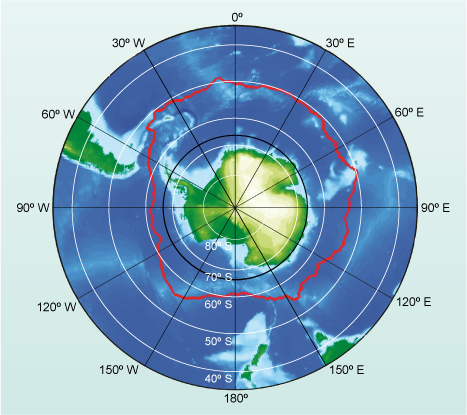
Clearly the treeline is not going to be a sensible way of defining the boundary of the Antarctic. As a continent, it is similar to Greenland in that it is covered in a very large ice cap with only a tiny fraction of the land being ice-free. Figure 16 shows Antarctica and the location of the Antarctic Circle at 66.6° S as a solid black line. At the beginning of this section you encountered the island of South Georgia north of the circle.
How much of South Georgia is covered in ice?
Almost 60% of the island is ice-covered.
To define the Antarctic it would clearly be a good thing to include South Georgia, as much of it is covered in ice and snow. Unfortunately there is no simple way. In terms of international law, Antarctica is land that is south of 60° S; but animals that only live in the Antarctic can be found as far north as 52° S. Which is right? Both are, to a certain extent, but the reason the cold environment extends so far north is that around Antarctica is a strong cold clockwise-circulating ocean current which isolates the ocean and lands to the south. This is the Antarctic Circumpolar Current, and the northern boundary of it is marked in red in Figure 16.
Find the location of South Georgia on Figure 16 at 54° S, 36° W. Which side of the red boundary is it on?
The island is south of the boundary.
South of the red boundary in Figure 16, Antarctic animals can range freely and icebergs, pieces of glacier that have broken off and are drifting in the ocean, can be expected at all times in the cold waters. Because it marks the division between polar and more temperate oceans, the boundary is called the Polar Front. For this course the Antarctic is defined as the region south of the Polar Front.