The Moon
Use 'Print preview' to check the number of pages and printer settings.
Print functionality varies between browsers.
Printable page generated Thursday, 25 April 2024, 8:29 PM
The Moon
Introduction
This course deals with the Moon, the only planetary body that everyone is familiar with seeing in the sky. You will learn about the nearest planetary body to Earth, the long record of cratering on its surface, and about the ancient eruptions that flooded many low-lying areas. If possible, it would be helpful to get a look at the Moon's surface before studying this course (even if you have no optical aid available), but don't worry if you are unable to do this.
This OpenLearn course provides a sample of level 1 study in Science
Tell us what you think! We’d love to hear from you to help us improve our free learning offering through OpenLearn by filling out this short survey.
Learning outcomes
After studying this course, you will be able to:
retrieve, evaluate and interpret data and information about the Moon
interpret simple tables
express, manipulate and compare very small numbers.
1 Observing the Moon
Activity 1
Try to make out features on the surface of the Moon, even if you have no optical aid available. If you have the use of a pair of binoculars you will probably be surprised by how much you can see (especially if you avoid full Moon). A telescope is even better, provided it can be held steadily enough. If you can get a look at the Moon's surface before studying the rest of the course, so much the better.
Now study Chapter 6 of Teach Yourself Planets, available in Section 2 page by page, followed by the guided discussion. Note that all references in Chapter 6 of Teach Yourself Planets to other chapters, are to other chapters of Teach Yourself Planets - these references are not to other sections of this course.
2 Studying the set text: Chapter 6 of Teach Yourself Planets
2.1 The Moon
David A. Rothery Teach Yourself Planets, Chapter 6, pp. 66-75, Hodder Education, 2000, 2003.
Copyright © David Rothery
In this chapter you will learn:
about the nearest planetary body to the Earth
about the long record of impact cratering on its surface, and about the ancient eruptions that flooded many low-lying areas.
| Planetary facts | |
|---|---|
| Equatorial radius (km) | 1738 |
| Mass (relative to Earth) | 0.0123 (7.35 × 10²² kg) |
| Density (g/cm3) | 3.34 |
| Surface gravity (relative to Earth) | 0.17 |
| Rotation period | 27.32 days |
| Axial inclination | 6.67° |
| Distance from Earth | 384,400 km |
| Orbital period | 27.32 days |
| Orbital eccentricity | 0.05 |
| Composition of surface | rocky |
| Mean surface temperature | 1 °C |
| Composition of atmosphere | argon, helium, atomic oxygen, sodium, potassium |
| Atmospheric pressure at surface (relative to Earth) | 2 × 10⁻¹⁴ |
| Number of satellites | 0 |
2.2 Rotation and orbit
David A. Rothery Teach Yourself Planets, Chapter 6, pp. 66-75, Hodder Education, 2000, 2003.
Copyright © David Rothery
The Moon is a familiar object in our sky, because it is our nearest neighbour and the only natural object to orbit the Earth. As described in Chapter 02, this situation is thought to have arisen as the result of a giant impact, 4.5 billion years ago. Something that adds to the Moon's familiarity is that it always presents the same face towards us. This is because the Moon rotates exactly once per orbit, which is described as synchronous rotation. This is a phenomenon also exhibited by most of the satellites of the giant planets, and is brought about because tidal forces between the planet and its satellite slow the satellite's rotation until it matches its orbital period.
Although the Moon rotates once per orbit, with patience it is possible to see about 59 per cent of its surface from the Earth. One reason is that the Moon's proximity is such that the Earth's rotation results in slight but significantly different points of view from a single site across a 12-hour period. A similar change in perspective could be gained by moving from the north pole to the south pole. The other reason is that although the Moon rotates at an exactly constant rate, its progress round its orbit varies slightly in accordance with Kepler's second law of planetary motion (Chapter 02). However, the terrain near the edge of the lunar disc is never well displayed, because we only ever see it obliquely, and there remains 41 per cent of the lunar surface that can never be seen from the Earth.
2.3 Missions to the Moon
David A. Rothery Teach Yourself Planets, Chapter 6, pp. 66-75, Hodder Education, 2000, 2003.
Copyright © David Rothery
The Moon was the first extraterrestrial target for space missions. Probes have been directed towards it since almost the very dawn of the space age (see below), and it was the main focus of the 1960s-1970s 'space race' between the USA and the then Soviet Union. In the end, only NASA attempted to put people on the Moon, and the six successful Apollo landings brought back a total of 382 kg of lunar rocks. These samples, together with 0.3 kg collected from other sites by unmanned Soviet sample return missions, are what has enabled us to calibrate the cratering timescale and were immensely important in developing our current level of understanding of the Moon's origin and history.
The budget for the Apollo programme was terminated in 1972, after which there was little further effort in lunar exploration until 1994 when the Clementine probe went into lunar orbit and collected a wealth of previously unknown information about the topography, crustal thickness, and variations in crustal composition across the whole lunar globe (Plate 2 [image can be found at: nssdc.gsfc.nasa.gov/planetary/ice/ice_moon.html]). This was followed in 1998 by another orbiter, Lunar Prospector, which provided even more insights and discoveries, such as the existence of ice dispersed within the regolith at both poles. The European Space Agency and Japan each plan lunar missions for the early years of the twenty-first century.
| Name | Description | Date |
|---|---|---|
| Luna 2 | impact with surface | Sept. 1959 |
| Luna 3 | fly-by, images of far side | Oct. 1959 |
| Rangers 7-9 | images at close range prior to impact | Mar. 1965-July 1972 |
| Luna 9 | unmanned landing, pictures from surface | Feb. 1966 |
| Luna 10 | first probe to orbit Moon | Apr. 1966 |
| Surveyor 1, 3, 5-7 | unmanned landings, images from surface | June 1966-Jan. 1968 |
| Lunar Orbiter 1-5 | images from orbit | Aug. 1966-Aug. 1967 |
| Luna 11-12 | images from orbit | Aug.-Oct.1966 |
| Apollo 8 | first manned orbits | Dec. 1968 |
| Apollo 11, 12, 14-17 | manned landings, geological and geophysical studies, sample return | July 1969-Dec. 1972 |
| Luna 16, 20, 24 | unmanned sample returns | Sept. 1970-Aug. 1976 |
| Luna 17, 21 | Lunokhod unmanned surface rovers | Nov. 1970, Jan. 1973 |
| Galileo | fly-by en route to Jupiter, compositional mapping | Dec. 1992 |
| Clementine | high resolution multispectral imaging and laser altimetry from orbit | Jan-Mar. 1994 |
| Lunar Prospector | geophysical and geochemical mapping from orbit | Jan. 1998-July 1999 |
| SMART 1 | European Space Agency lunar orbiter | 2003 |
| Lunar A | Japanese lunar orbiter and seismometers | 2003 [cancelled] |
| Selene 1 | Japanese lunar orbiter and lander | 2004 [actual launch, 2007] |
2.4 The atmosphere and polar ice
David A. Rothery Teach Yourself Planets, Chapter 6, pp. 66-75, Hodder Education, 2000, 2003.
Copyright © David Rothery
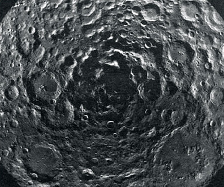
The Moon's atmosphere is almost as insubstantial as Mercury's, and probably has much the same origin. The Clementine mission returned our first clear views of the lunar poles, showing sites in particular near the south pole that are permanently in shadow, and which could therefore be places where ice might accumulate (Figure 1). Clementine's simple radar gave the first indications that water is present there, and this theory was dramatically backed up by measurements by Lunar Prospector that show a reduction in the average speed of neutrons (produced by cosmic radiation) over both lunar poles. The only reasonable explanation of this seems to be collisions between neutrons and the hydrogen atoms within ice molecules, and it now seems that there may be as much as 3 billion tonnes of ice mixed with the regolith at each pole. This is not a lot in terms of the size of the Moon (it is the equivalent of a 1.5 km cube of ice at each pole), but could be ample to supply the immediate needs of human habitation on the Moon.
2.5 The interior
David A. Rothery Teach Yourself Planets, Chapter 6, pp. 66-75, Hodder Education, 2000, 2003.
Copyright © David Rothery
The Moon is the only planetary body other than the Earth for which we have any seismic data that can tell us about its interior. Seismic stations were established at the Apollo 12,14, 15 and 16 sites, which continued to send back data until September 1977 when operations were terminated for budgetary reasons. The Moon is seismically very quiet compared to the Earth, with moonquakes being many orders of magnitude less powerful than typical earthquakes. The Apollo seismometers also detected the vibrations from deliberate crashes of various expended units of the Apollo spacecraft and from meteorite impacts, including one from the far side that gave crucial data on the maximum possible size of the lunar core.
The picture that has emerged from combining Apollo seismic data with topographic and gravitational mapping by Clementine and Lunar Prospector is as follows. The Moon's crust is on average about 70 km thick, but exceeds 100 km in some highland regions and falls to about 20 km thick below some impact basins. The crust is thicker on the far side, with the result that the Moon's centre of mass is offset from its geometric centre by about 2 km toward the Earth.
The mantle is rigid to a depth of about 1000 km, which is also the greatest depth for the source of moonquakes, so this marks the base of the lunar lithosphere, below which it is probably slowly convecting. Like the Earth's mantle, that of the Moon is approximately peridotite in composition, though there are signs that it varies in detail from region to region.
The Moon's core is between about 220 and 450 km in radius (so the core-mantle boundary is at least 1290 km depth), and is probably iron-rich and solid. It makes up less than 4 per cent of the Moon's total mass, a much smaller fraction than for any of the other terrestrial planets. This can be explained by computer models of the giant impact in which the Moon was born. These show the core of the impacting body accreting onto the core of the proto-Earth, whereas the Moon formed from the mixture of fragments of the two bodies' mantles that were thrown into space. There is no magnetic field generated in the Moon's core today, showing that it must be solid. However, there are local weak remanent magnetic fields associated with some of the Moon's major impact basins, which suggest that part of the core may still have been liquid and generating a global field when these formed 3.6 billion years ago.
2.6 The surface
David A. Rothery Teach Yourself Planets, Chapter 6, pp. 66-75, Hodder Education, 2000, 2003.
Copyright © David Rothery
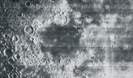
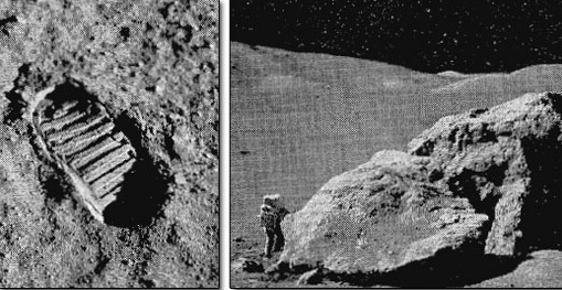
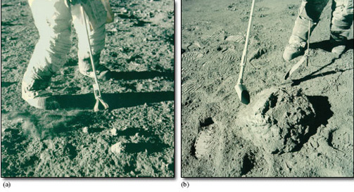
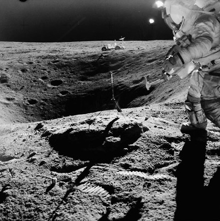
Look at the Moon even with the unaided eye, and you will see that it has dark patches on a paler background (Figure 2). This simple observation picks out the two distinct types of crust on the Moon. The paler areas are the lunar highlands, and the darker areas are the lunar 'seas' or maria (singular: mare). Both the highlands and the maria have very little bedrock exposed at the surface, because it is buried by several metres of regolith composed of ejecta from crater-forming impacts at all scales. In detail the regolith consists of a mixture of rock fragments, crystal fragments and droplets of glass (which are congealed globules of melt produced by impacts). This forms a 'soil' capable of bearing the imprint of a booted foot (Figure 3, left), but there are also scattered boulders of a variety of sizes (Figure 3, right).
The highlands are the first lunar crust to have formed, probably by crystals rising to the surface of the 'magma ocean' thought to have covered the young Moon as a result of the heat generated by collision of the Moon-forming fragments. Because of the preponderance of the mineral anorthite (a calcium-rich variety of the mineral plagioclase feldspar) this rock type is called anorthosite. The oldest anorthosite sample collected from the Moon has been dated at 4.5 billion years. However, most highland rock samples consist of fragments of rock that were welded together between about 4 and 3.8 billion years ago. These reflect the heavy bombardment suffered by the highland surface until the rate of impact cratering declined towards its current level.
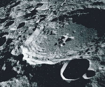
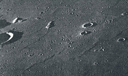
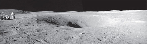
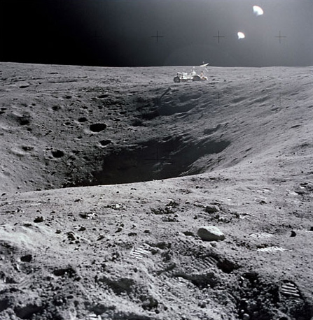
The high degree of cratering suffered by the highland crust is notable in the view seen in Figure 4. This also illustrates the dependence of crater morphology on crater size. Craters less than about 15 km across are simple bowl-shaped depressions with raised rims, but the largest crater in this view has the terraced inner walls and central peak that are characteristic of craters larger than this. At yet larger diameters the central peak is replaced by a ring of peaks, as in the crater in the lower right of Figure 1. The largest impact structures of all are multiringed impact basins (like Mercury's Caloris basin), dating from 4 to 3.8 billion years ago. The 2500 km diameter South Pole Aitken basin (Plate 2 [image can be found at nssdc.gsfc.nasa.gov/planetary/ice/ice_moon.html]) is the largest lunar example, but there are several others, one of which is now occupied by the Mare Humorum near the centre of Figure 2.
All the Moon's multiringed impact basins are older than the Moon's second kind of crust. This consists of basalt lava that has flooded low-lying areas to form the lunar maria. Many of the maria occupy multiringed impact basins, and it was once thought that the melting to produce the mare-filling basalts was a direct response to the basin-forming impacts. However, the ages of samples of mare basalt that have been returned to Earth range from 3.8 to 3.1 billion years old, so clearly the magma generation was triggered by unrelated events, and the magma ended up in the basins merely because it took advantage of the easiest routes to the surface. Inspection of detailed images of some mare areas that have not been sampled suggests that the mare-forming eruptions did not fully cease until about 1 billion years ago. The only extensive mare regions are on the lunar near side. Most of the far side features, even the South Pole Aitken basin, have escaped mare flooding, presumably because of the greater thickness of far side crust.
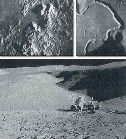
The mare basalts probably came into place as a series extensive lava flows, amounting to some hundreds of metres in total thickness. In some places, such as in Figure 5, the margins of individual lava flows can still be seen, and elsewhere there is spectacular evidence of the lava having flowed in tubes, which are revealed by later collapse of their roofs. A good example of this is seen in Figure 6, which shows Hadley Rille, the main focus of the Apollo 15 surface explorations. Most of the top left view shows the Apennine mountains, which are highland crust forming the rim of the Imbrium basin (a large near side multiringed impact basin). Hadley Rille emerges from an unseen source at the edge of the mountains, and snakes across the much flatter mare basalt terrain, appearing to have acted as a channelway that fed the later stages of mare flooding. It probably became roofed over by chilled and solidified lava, and this insulating cap enabled a vast quantity of lava to continue to flow through the tube without congealing. The rille is now visible because the roof of the tube collapsed at some time after it became drained of lava.
2.7 Living on the Moon?
David A. Rothery Teach Yourself Planets, Chapter 6, pp. 66-75, Hodder Education, 2000, 2003.
Copyright © David Rothery
The projected date for a permanent lunar base seems to have been receding into the future ever since the demise of the Apollo programme. However, unless we give up space exploration entirely it is bound to happen eventually. One major objection to lunar habitation, the lack of water, has now been removed with the discovery of substantial quantities of ice near the poles. No convincing reasons have yet emerged for basing industries on the Moon. However, apart from the advantages for lunar exploration itself, the far side would offer an excellent place from which to do radioastronomy, shielded from the increasing interference from mobile phones and the like.
3 Discussion of Chapter 6
3.1 Comments and explanations
Read the following comments and explanations before answering the questions in the rest of the course (on this page and Section 3.14).
As is the convention for satellites, the Moon's rotation period is defined in the Planetary facts table relative to the planet that it orbits rather than relative to the universe as a whole. This is a different convention from the one adopted for planets themselves.
The Moon's synchronous rotation enables the line of zero longitude to be defined on a logical principle, in contrast to the arbitrary basis used on the terrestrial planets. Lunar zero longitude is defined as running centrally across the Moon's Earth-facing hemisphere. The same principle is used to define zero longitude on synchronously-rotating satellites of other planets.
Section 2.2 mentions Kepler's second law of planetary motion in connection with the Moon's orbit round the Earth. Although originally formulated to describe the motion of a planet about the Sun, Kepler's laws also describe the motion of a satellite around any other body. Beware though that you cannot use Kepler's third law to relate orbital periods of bodies that do not orbit the same central body, because the orbital period depends on the mass of the central body.
The evidence for ice near the lunar poles is stronger than that for ice on Mercury, where we have only radar reflections using signals transmitted from the Earth. For the Moon there are two sorts of useful data, both of which were collected from lunar orbit: radar reflections detected by Clementine over the south pole (Section 2.4), and the neutron signature detected by Lunar Prospector over both poles (also Section 2.4). You are not expected to understand how the neutron signature is derived, or why it indicates ice. You can see the specific locations where Clementine indicated ice in Figure 1.
In case you were wondering, maria (meaning 'seas', and used only for regions on the Moon) is not pronounced like the girl's name. You should say 'MAH-ree-a'. The singular, mare, should be pronounced 'MAH-ray'.
Section 2.6 points out that almost all the lunar surface is covered by a layer of fragmental material (regolith) resulting from meteorite impacts. Figure 3 does not give a terribly clear impression of this, so take a look at Figure 7 below. The variety of fragment sizes is apparent, as well as the ability of the regolith to retain the imprint of a booted foot. You can also gain a good insight into what it is like on the lunar surface by looking at the panoramas that are provided as Moon34-45 below.
Figures in Chapter 6 illustrate lunar craters as small as the 300 m Elbow crater in the top right part of Figure 6. Figure 8 below shows a 40 m crater named Plum. Younger craters less than a metre across are clearly visible where sunlight falls at a grazing angle onto the inner slope of Plum in Figures 9 and 10.
It was once widely assumed that lunar craters are a result of past volcanic activity. This concept was well and truly debunked from the 1960s onwards by new understanding of the impact process, and by recognition of impact craters on all ancient surfaces in the Solar System and at all scales. In fact, very few recognisable craters on the Moon are volcanic.
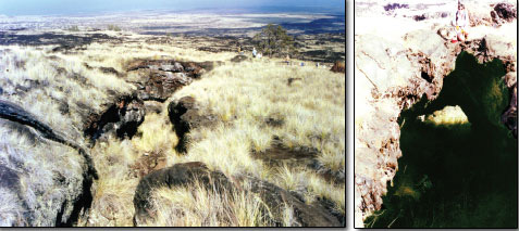
Section 2.6 describes long, winding valleys interpreted as collapsed lava tubes that indicate the paths along which lava flowed to fill the mare basins, but only one example (Hadley Rille) is illustrated (Figure 6.6). This photograph is part of the panorama of Moon41. It is unlikely that the lava tube explanation for such features on the Moon would have been dreamt up, unless similar (though smaller-scale) features were already known on the Earth. Unless you are very lucky, you are unlikely to have seen one of these, so Figure 11 shows you an example.
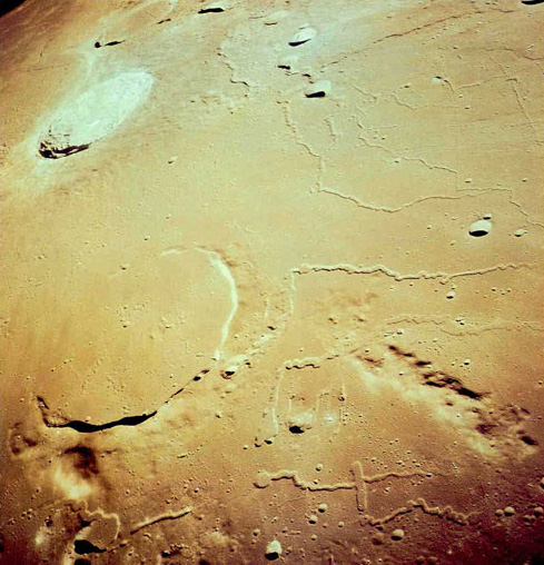
Because their origin as lava tubes cannot often be proven, it is more usual to refer to these as rilles. There are several rilles visible in Figure 12. It is well worth examining this image, because it conveys a lot of information about lunar history.
Activity 2
How can you tell that the large crater (Prinz) in the left foreground of Figure 12 is older than the large crater beyond it (Aristarchus)?
Answer
Prinz was clearly formed before this region became covered by mare basalts. It became largely flooded by these basalt lava flows which overtopped its rim on the far side. Conversely, Aristarchus (and its associated ejecta blanket) can be seen to have been formed on top of the mare basalts. You might also note the considerable number of small impact craters on the mare surface within Prinz, whereas few or no such craters are visible within Aristarchus or on its ejecta blanket, which demonstrates that Aristarchus post-dates most of the cratering that has affected the mare surface.
3.2 Moon34: Apollo 11 station 3
This panorama was collected by Neil Armstrong from a spot north east of the landing module at the Sea of Tranquility. (QuickTime, 500KB, note: this may take some time to download depending on your connection speed)
The imagery was prepared as part of a project by a USGS team under funding from the USGS Technology Transfer Program and NASA's Planetary Geology and Geophysics Program.
3.3 Moon35: Apollo 11 station 4
This panorama was collected by Neil Armstrong from a spot east of the landing module while Buzz Aldrin was unloading the science packages. (QuickTime, 500KB, note: this may take some time to download depending on your connection speed)
The imagery was prepared as part of a project by a USGS team under funding from the USGS Technology Transfer Program and NASA's Planetary Geology and Geophysics Program.
3.4 Moon36: Apollo 12 station 2
Pete Conrad took this pan early in EVA-1 from a position due west of the Lunar Module. Al Bean can be seen in several frames taking documentation photos of the Solar Wind Collector (SWC) that he has just deployed. (QuickTime, 500KB, note: this may take some time to download depending on your connection speed)
The imagery was prepared as part of a project by a USGS team under funding from the USGS Technology Transfer Program and NASA's Planetary Geology and Geophysics Program.
3.5 Moon37: Apollo 12 station 3
The panorama was collected by Charles "Pete" Conrad. (QuickTime, 500KB, note: this may take some time to download depending on your connection speed)
The imagery was prepared as part of a project by a USGS team under funding from the USGS Technology Transfer Program and NASA's Planetary Geology and Geophysics Program.
3.6 Moon38: Apollo 12 station 5
Two of the frames show Al Bean carrying the Apollo Lunar Surface Experiments Package (ALSEP) packages out from the Lunar Module. (QuickTime, 500KB, note: this may take some time to download depending on your connection speed)
The imagery was prepared as part of a project by a USGS team under funding from the USGS Technology Transfer Program and NASA's Planetary Geology and Geophysics Program.
3.7 Moon39: Apollo 14 station C
The panorama was collected by Alan Shepard at station C-Prime. (QuickTime, 500KB, note: this may take some time to download depending on your connection speed)
The imagery was prepared as part of a project by a USGS team under funding from the USGS Technology Transfer Program and NASA's Planetary Geology and Geophysics Program.
3.8 Moon40: Apollo 14 station H
The panorama was collected by Edgar Mitchell at station H. Alan Shepard is to the left of the lander aiming the TV camera at the MESA. (QuickTime, 500KB, note: this may take some time to download depending on your connection speed)
The imagery was prepared as part of a project by a USGS team under funding from the USGS Technology Transfer Program and NASA's Planetary Geology and Geophysics Program.
3.9 Moon41: Apollo 15 station 2
The panorama was collected by James B. Irwin at Station 2. David Scott is to the left of the rover. He is examining a boulder. The large hill to the left of the rover is the summit of Mt. Hadley Delta. (QuickTime, 400KB, note: this may take some time to download depending on your connection speed)
The imagery was prepared as part of a project by a USGS team under funding from the USGS Technology Transfer Program and NASA's Planetary Geology and Geophysics Program.
3.10 Moon42: Apollo 15 station 10
James B. Irwin took this pan moments after he and Dave Scott arrived at Station 10. (QuickTime, 500KB, note: this may take some time to download depending on your connection speed)
The imagery was prepared as part of a project by a USGS team under funding from the USGS Technology Transfer Program and NASA's Planetary Geology and Geophysics Program.
3.11 Moon43: Apollo 16 station 1
Astronaut Charles Duke photographed collecting lunar samples at Station 1 (near Flag Crater). (QuickTime, 200KB, note: this may take some time to download depending on your connection speed)
The imagery was prepared as part of a project by a USGS team under funding from the USGS Technology Transfer Program and NASA's Planetary Geology and Geophysics Program.
3.12 Moon44: Apollo 17 station 1
The panorama was collected by Eugene Andrew Cernan at Station 1. Harrison H. "Jack" Schmitt is holding the rake. (QuickTime, 500KB, note: this may take some time to download depending on your connection speed)
The imagery was prepared as part of a project by a USGS team under funding from the USGS Technology Transfer Program and NASA's Planetary Geology and Geophysics Program.
3.13 Moon45: Apollo 17 station 2
The panorama was collected by Eugene Andrew Cernan at Station 2. Harrison H. "Jack" Schmitt accompanies Gene on this EVA. (QuickTime, 200KB, note: this may take some time to download depending on your connection speed)
The imagery was prepared as part of a project by a USGS team under funding from the USGS Technology Transfer Program and NASA's Planetary Geology and Geophysics Program.
3.14 Questions on the Moon
Now try to answer the following questions, to remind you of some of the things you have learned and test your understanding of them.
Question 1
The first sentence of Section 2.4 describes the Moon's atmosphere as 'almost as insubstantial as Mercury's'. If Mercury's atmospheric pressure is 10-15 relative to that of the Earth, use the atmospheric pressure data in the Planetary facts table of Chapter 6 to calculate how the Moon's atmospheric pressure compares with Mercury's in terms of orders of magnitude. (Refer to Box 1 below if you need help.)
Answer
The Moon's atmospheric pressure is quoted as 2 × 10-14, relative to Earth, whereas Mercury's is 10-15. Thus, the Moon's atmospheric pressure relative to Mercury's is 2 × 10-14 / 10-15 = 2 × 101 = 20. This is closer to ten than to a hundred, so we would say that the Moon's atmospheric pressure is one order of magnitude greater than Mercury's.
Box 1: Orders of magnitude and multiplying and dividing powers of ten
Orders of magnitude
Mercury's atmospheric pressure is quoted as 10-15 that of the Earth (we could write it more fully as '1 × 10-15', but the '1 ×' is redundant). In this case the power of ten is preceded by a minus sign, and it means that the number is 1 divided by 1 followed by 15 zeros (i.e. 1 divided by 1015, or 1/(1015), which is 0.000 000 000 000 001). That makes a very small number indeed. We can describe Mercury's atmospheric pressure as being 15 orders of magnitude less than the Earth's.
A value that is about ten times smaller than another is described as one order of magnitude smaller, about a hundred times smaller is described as two orders of magnitude smaller, etc. Turning this round, we can equally speak of one value being so many orders of magnitude greater than another. Values that differ by less than an order of magnitude are described as being 'of the same order of magnitude'. For example, 400 and 600 are of the same order of magnitude (as each other), and so are 9 × 10³ and 2.5 × 10⁴. Even though in the second case the two values have different powers of ten, the larger value is in fact less than three times greater than the smaller one.
Incidentally, you would say 10-15 as 'ten to the minus fifteen' and 1015 as 'ten to the fifteen'.
Multiplying and dividing powers of ten
When we multiply two numbers expressed in scientific notation, the rule is to multiply the numbers but add the powers of ten.
To calculate A × 10fmultiplied by B × 10g we simply work out A × B × 10f+g (note that we add the powers).
So, for example 3 × 106 × 5 × 103 = 3 × 5 × 106+3 = 15 × 108 (which we could express as 1.5 × 10⁹ if we want to make the number before the × take a value of between 1 and 10).
On the other hand, to calculate A × 10fdivided by B × 10g we simply work out (A ÷ B) × 10f−g (note that we subtract the powers).
So, for example, 3 × 10⁶ ÷ 5 × 103 = 3/5 × 106−3 = 0.6 × 10³ (which we could express as 6 × 10² if we want to make the number before the × take a value of between 1 and 10).
Question 2
Look at the basic properties of the Moon listed in the Planetary facts table of Chapter 6. Which of these do you think is likely to exert the greatest influence on the ease with which liquid lava can flow on the Moon relative to its behaviour on the Earth?
Answer
You might have picked temperature, on the grounds that lava will solidify quicker on a colder body. However, the Moon's average surface temperature is not much lower than the Earth's, so this is not actually the principal factor. The big difference between the two bodies is surface gravity. The Moon's surface gravity relative to the Earth is only 0.17 (about a sixth of the Earth's). This means that the force acting to spread flowing lava away from its source is six times weaker on the Moon than on the Earth. Lunar lava flows should thus tend to be thicker than equivalent flows on Earth. [Comment: This may be one of the reasons why lava tubes on the Moon have been able to attain much bigger dimensions than lava tubes on the Earth.]
Question 3
a.
A. Apollo seismic data show that the Moon's lithosphere is on average about 70 km thick.
b.
B. The Moon's core is thought to be at least 1290 km across.
c.
C. The lunar highlands are older than the maria.
d.
D. There are no lava flows on the Moon.
e.
E. The outer part of the core is liquid.
The correct answer is c.
Answer
A. is incorrect. 70 km is the average thickness of the crust (Section 2.5), not of the lithosphere - the base of which is quoted as 'about 1000 km' in the same section.
B. is incorrect. 1290 km is the minimum likely depth to the top of the core (Section 2.5).
C. is correct, as demonstrated by crater densities and from samples dated using natural radioactivity (Section 2.6).
D. is incorrect. The maria are basins that were flooded by lava (Section 2.6), which is still there (even though it has long since solidified).
E. is incorrect. The fourth paragraph of Section 2.5 gives reasons for supposing that the whole of the Moon's core is now solid.
Conclusion
This free course provided an introduction to studying Science. It took you through a series of exercises designed to develop your approach to study and learning at a distance, and helped to improve your confidence as an independent learner.
Acknowledgements
Course image: Dylan O'Donnell in Flickr made available under Creative Commons Attribution-NonCommercial-ShareAlike 2.0 Licence.
The following material acknowledged below is Proprietary and used under licence and not subject to Creative Commons licence (see terms and conditions).
Grateful acknowledgement is made to the following sources for permission:
Rothery, David A., Teach Yourself Planets, Chapter 6, pp. 66-75, Hodder Education, 2000, 2003. Copyright © David Rothery.
Figures from Teach Yourself Planets
Figure 6.1: David Rothery; Figures 6.2, 6.3, 6.4, 6.5, 6.6: NASA.
Other figures
Figures 2, 3, 4, 5, 6: NASA. The panoramas were prepared as part of a project by a USGS team under funding from the USGS Technology Transfer Program and NASA's Planetary Geology and Geophysics Program.
Figure 7: Mr Frederick J. Doyle, National Space Science Data Center.
Don't miss out:
If reading this text has inspired you to learn more, you may be interested in joining the millions of people who discover our free learning resources and qualifications by visiting The Open University - www.open.edu/ openlearn/ free-courses