Practising science: reading the rocks and ecology
Use 'Print preview' to check the number of pages and printer settings.
Print functionality varies between browsers.
Printable page generated Wednesday, 24 April 2024, 9:21 AM
Practising science: reading the rocks and ecology
Introduction
Science is all about knowledge, what we know about the material world and the Universe in which our world is just a microscopic speck. The aim of scientists is to extend the frontiers of this knowledge so that we can understand more about the physical Universe and the life within it.
Scientists acquire knowledge by engaging in four fundamentally important and connected tasks. The first is observation: they observe the natural world and the space beyond it, and both describe and record what they see. Second, they construct hypotheses to explain what they see. Third, they carry out experiments where possible to test their hypotheses. Finally they communicate their findings – to other scientists who will build on this work to extend knowledge still further, to technologists who will devise practical applications for scientific knowledge, and to the general public to raise awareness of scientific discovery. The way in which science is communicated to interested parties is especially important because scientific knowledge is useless if no one else can understand it.
This free course, Practising science: reading the rocks and ecology, introduces some of the background needed for students taking part in the earth science and ecology activities which often take place at science residential schools. At such schools, students normally undertake laboratory and field based activities in earth science, biology, physics and chemistry. You will learn about the types of activities undertaken by students of the earth sciences and ecology, as well as how data is collected and analysed.
Radio 4's ‘The Material World’ broadcast three programmes from Open University Residential Schools, including SXR103 Practising Science. If you'd like to listen to this, go to http://www.bbc.co.uk/radio4/science/thematerialworld_20060810.shtml.
In addition, you can visit our Geology Toolkit for an interactive overview of the landscape of the British Isles.
This OpenLearn course provides a sample of Level 1 study in Science.
Learning outcomes
After studying this course, you should be able to:
explain the difference between a mineral and a rock
describe the textural differences between igneous, sedimentary and metamorphic rocks
account for these differences in terms of the processes that produce these rocks
classify igneous rocks according to their grain size and mineralogical composition
recognise the difference between a body fossil and a trace fossil.
1 Earth Sciences: reading the rocks
The Earth Sciences concern every part of our planet – from the centre of the metallic core, 6400 km below our feet, through its solid and liquid regions (see Figure 1 on the next page) to the outer reaches of the atmosphere. We will concentrate on the outermost, rocky part of the solid Earth; in other words, the rocks of the Earth's crust that form the outermost layer of the lithospheric plates.
1.1 The Earth's crust
On the scale of a human lifetime, these rocks and the landscapes of which they are part can seem static and immutable, at least in a country such as Britain where there are no active volcanoes, and earthquakes are infrequent and fairly small. None the less, coastal erosion and the biological degradation of rocks to form soils are reminders that geological processes are occurring ‘in our own backyard’ and that the Earth's surface is continuously being reshaped.
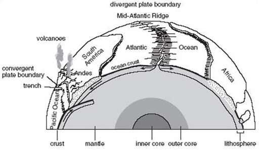
Over hundreds of millions of years, the surface of the Earth is rearranged by the slow grind of geological processes. In particular, the rigid outer layer of the Earth (some 100 km thick and known as the lithosphere) is divided into about a dozen plates, which change shape, size and position as their margins experience growth, destruction or collision (see Figure 1). So, although the processes can be very slow, given enough time the results include the generation and destruction of mountain ranges that stretch across continents, and the opening and closing of ocean basins. All these geological processes leave their mark by forming new rocks. And those rocks, whether sandstone formed from sand in a desert, or volcanic lava flows, hold clues to the processes that formed them, and therefore the conditions at the time of their formation. In some cases they contain information on past climatic conditions, and some rocks contain fossils that reveal the history of life and the story of evolution. Rocks can provide a narrative of the Earth's history, but we need to learn how to read their tales.
The aims of this section are to demonstrate how many of the features shown by rocks are inherited from the processes that formed the rock, to introduce you to the skills of sketching features seen in rock exposures, and to show how those features can be interpreted in a simple sequence of events through geological time.
1.2 Minerals and rocks
To begin with, it is necessary to explain the meanings of the two terms ‘minerals’ and ‘rocks’.
1.2.1 Minerals
A mineral is a solid material, formed by natural processes and with a chemical composition that falls within certain narrow limits. Its constituent atoms are arranged in a regular three-dimensional array or pattern and because of this, minerals form crystals with characteristic shapes.
Although several thousand different kinds of mineral have been discovered, only a few are very common; for example, the mineral quartz, which forms many of the sand grains on a beach or in a desert. Because silicon and oxygen are the two most abundant elements in the Earth's crust, they are the main ingredients of common minerals, and these minerals are known as silicate minerals. They include quartz, whose chemical composition is silicon dioxide (formula SiO2), and a range of others containing additional common chemical elements. A common mineral that is not a silicate is calcite; it has the chemical composition calcium carbonate (CaCO3). Whereas most minerals are identified on the basis of physical characteristics (density, hardness, colour, etc.) calcite can also be readily identified with a chemical test. Calcite reacts with dilute hydrochloric acid, liberating bubbles of carbon dioxide (CO2) gas in a vigorous fizzing froth. The chemical reaction is written as

In words, this equation can be expressed as: solid calcium carbonate (calcite) plus hydrogen ions in the acid plus chloride ions in the acid gives calcium ions, hydroxide ions and chloride ions dissolved in solution plus carbon dioxide gas.
1.2.2 Rocks
Any naturally formed solid assemblage of mineral grains can be described as a rock. The mineral grains may be fragments of crystals or intact crystals and their size can range from a few micrometres (1 micrometre = 10−6m) to a few centimetres. A rock may consist of one type of mineral but more usually it consists of several minerals. Rocks can be classified according to the way in which the grains are arranged, although the identity of the minerals present (for example, the rock limestone is made mostly of calcite), the proportions of particular minerals, and the dominant size of mineral grains are also important. The shape of the grains in a rock, their size and the relationship between them (for example, whether or not the grains interlock with each other to form a mosaic) define the texture of a rock, and reflect the processes that formed it. A rock's texture has nothing to do with how the rock feels when you touch it. To ‘read the rocks’ and discover how any particular rock formed, we investigate its texture and work backwards to deduce the processes by which that texture was produced.
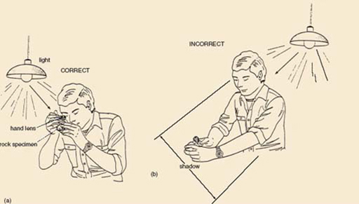
Because the mineral grains in most rocks are quite small it is often best to use a hand lens, typically with a magnification power of times 10, to get a clearer view. You may already have access to a small hand lens. If so, some notes on this are given in Box 1, Using the hand lens.
Box 1 Using the hand lens
The correct way to examine objects with a hand lens is shown in Figure 2. Some additional hints are:
Hold the hand lens 2–3 cm from your eye and bring the object up towards the lens until it is in focus.
Make sure the surface of the object is well lit from the side.
Keep the hand lens and the object parallel to each other and hold both steady.
With rough surfaces you have to move the object back and forth to bring different parts into focus.
Rocks may be classified into three types, according to the three processes that form rocks:
Igneous rocks: these are formed from molten rock (magma) that becomes solid when it cools, either deep underground or after a volcanic eruption at the surface.
Sedimentary rocks: these are formed when eroded particles of pre-existing rocks (in other words sediment, such as sand on a beach or mud on the sea-bed) have been laid down in layers at the surface of the Earth and turned into solid rock by being buried and compacted under more layers of sediment.
Metamorphic rocks: these are existing rocks that have ‘changed form’ by the action of high pressure or temperature causing new crystals to grow, for example after burial deep in the Earth.
Sections 1.4 to 1.6 describe how each of the three major rock types is formed and how their modes of formation can be deduced from the textures and other features visible in the rocks themselves – reading the rocks.
1.3 The formation of igneous rocks
Igneous rocks are defined as having solidified from a molten state, either inside the Earth or on the surface at volcanoes.
1.3.1 Igneous rocks in the landscape
The rocks that erupt from volcanoes are called extrusive igneous rocks, simply because they are formed by the extrusion of magma on to the Earth's surface. Igneous rocks can also form deep underground, and these are called intrusive igneous rocks, because the magmas were intruded into pre-existing rocks and then slowly cooled. The reason that intrusive igneous rocks are now visible at the surface is that over many millions of years erosion has stripped away the overlying rocks. In this way, bodies of igneous rock that were once subterranean pools of magma are revealed at the surface. Some of these intrusions can be up to several kilometres across. In other cases, magma had intruded pre-existing rocks to form long slab-shaped bodies of igneous rock whose longest dimensions are measured in kilometres but whose shortest dimension is no more than a few metres. These intrusions are called dykes in the case of vertical bodies, and sills in the case of horizontal bodies.
1.3.2 Texture of igneous rocks
What texture might we expect an igneous rock to have? An igneous rock will contain crystals that grew as the magma cooled. Each crystal will have started to grow unhindered by neighbouring crystals, so an igneous rock therefore has a crystalline texture in which the crystals are randomly oriented.
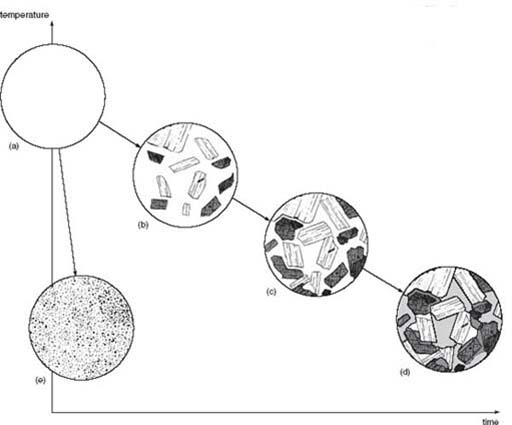
To picture this, consider magma at an initial temperature of perhaps 1000 °C, as it slowly cools underground (see Figure 3, path (a) to (d)). Initially the magma is completely molten (Figure 3a) but, unlike water placed in the ice box of a freezer, magma doesn't turn from being totally liquid to totally solid at a single temperature when it is cooled. Instead, different minerals crystallise over a range of temperatures (in fact over one or two hundred degrees Celsius). So, when the temperature of magma falls by a small amount, only a few mineral crystals will form (Figure 3b). On further cooling these crystals grow larger, and new minerals also start to crystallise (Figure 3c). Eventually, these crystals form an interlocking network, with the last crystals to grow filling the spaces between. When totally solidified, the rock has the crystalline texture shown in Figure 3d.
In contrast, very fast cooling allows crystallisation to occur by the nucleation of many small crystals rather than the steady growth of a few crystals. The resultant igneous rock contains innumerable tiny crystals that may be so tiny as to be indistinguishable except under the high magnification of a microscope (Figure 3, path (a) to (e)). In the most extreme case crystallisation is totally inhibited and the starting liquid is quenched to form volcanic glass.
Activity 1
Would you expect a fine-grained igneous rock to have formed deep below the Earth's surface or at the surface?
Answer
A fine-grained igneous rock requires rapid cooling and this is more likely at the surface, where magma comes into contact with air or water, rather than in the hot interior of the Earth.
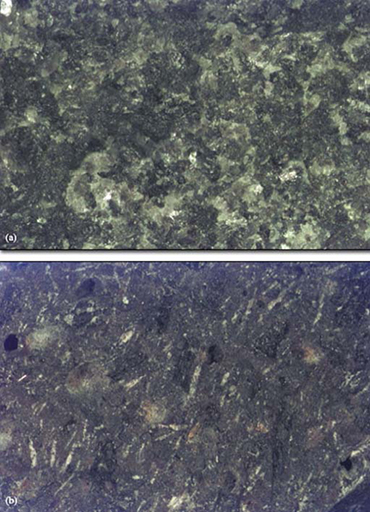
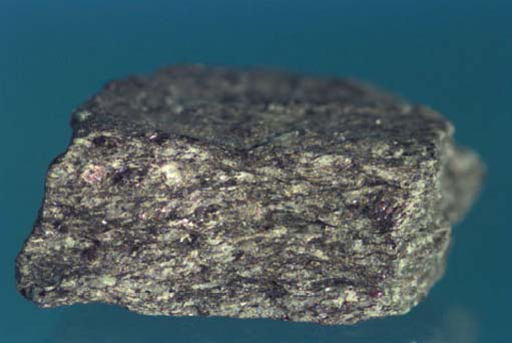
Generally speaking, the number and size of the crystals in an igneous rock depend on the amount of time available for their growth. The slower the cooling, the bigger the crystals. In the case of extrusive rocks, the amount of time is short – anything from a few seconds for droplets of magma flying through the air in an explosive volcanic eruption, to a few years for the interior of a thick lava flow. This results in small crystals (Figure 3e). For intrusive rocks, the cooling rate is much slower and there is time for larger crystals to grow (Figure 3d). (The times involved are not known for certain because the magma at depth cannot be observed.) Figure 4 illustrates this with two rocks of essentially similar chemical composition, but from different igneous settings. Figure 4a shows an intrusive rock containing crystals of mainly two minerals – one dark (this is the iron (symbol Fe) and magnesium (Mg) -bearing silicate mineral called pyroxene), the other pale (this is the calcium (Ca), sodium (Na), aluminium (Al) -bearing silicate mineral called plagioclase feldspar). The crystals are intergrown (cf. Figure 3d) and easily visible. In contrast, Figure 4b shows a rock collected from a lava flow. This rock has only a few crystals (pale) that are large enough to see, and this is because cooling and crystal growth were abruptly halted when the magma erupted and froze as lava. The rest of this rock is so finegrained that crystals are indistinguishable without the benefit of a microscope. There are, however, a few small round dark areas (e.g. near the top left edge) These are gas bubbles formed when the magma came to the surface and gases that were dissolved in the magma came out of solution as the pressure on the magma decreased.
1.3.3 Chemical and mineral composition of igneous rocks
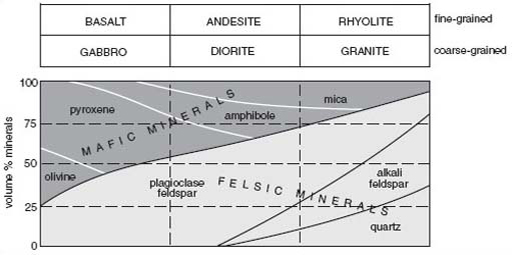
As well as varying in grain size (owing to different cooling rates), igneous rocks also vary in chemical composition and hence in the identity and proportions of minerals present. For instance, the common igneous rock granite contains (as part of the strict geological definition of the term ‘granite’) between 10% and 35% by volume of the mineral quartz (chemical composition silicon dioxide – SiO2). On the other hand, the igneous rock gabbro (Figure 4a) does not usually contain any quartz. This difference is due simply to the fact that granite contains a much higher proportion of the element silicon (Si) than does gabbro. So, chemical composition determines which minerals are present, and cooling rate determines the crystal size of those minerals.
1.3.4 Classifying igneous rocks
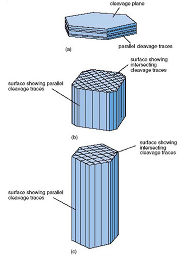
To classify (i.e. to name) igneous rocks, geologists use three pieces of information in combination – the grain size and the identity and proportions of the minerals present. The identification of minerals in a rock relies on recognising their particular distinguishing features. Such features include colour, lustre (the way in which light is reflected from the mineral's surface) and shape. The way in which certain minerals break apart along preferred planes, a property known as cleavage, can also be useful in identifying minerals because this property depends on the way that the mineral's constituent atoms are arranged. In some minerals the atoms are bound more strongly in some directions than in others, in which case there are natural planes of weakness present in the crystal. The mineral tends to break preferentially along these planes.
One mineral that shows this feature clearly is mica, a silicate mineral containing potassium (K), iron (Fe), magnesium (Mg) and aluminium (Al), together with hydroxyl (OH) groups. These compositional details needn't distract us, but the important point is that the potassium ions occur in layers, which separate sheets of more tightly bound silicon, oxygen and other atoms. Mica therefore splits apart parallel to the sheets, so has just one set of cleavage surfaces parallel to each other (Figure 5a). This is why mica forms platy or flake-like crystals, rather like the pages of a book. Other minerals can have two or three sets of cleavages (which intersect at characteristic angles) whereas others, notably quartz, have no cleavage and break irregularly.
The most common silicate minerals found in igneous rocks (most of which are also common in sedimentary and metamorphic rocks) are listed in Table 1: minerals rich in silicon appear towards the top, and those poorer in silicon but richer in magnesium and iron appear towards the bottom of Table 1.
| Mineral | Diagnostic features | Chemical composition |
|---|---|---|
| Quartz | Colourless to pale; glassy lustre (broken surfaces similar to broken glass); curved fractures; no visible internal structure | SiO2 |
| Feldspar | Pale pink or white; two good cleavages | Ca, Na, Al silicates. Feldspar that is rich in Ca and Na is known as plagioclase, if rich in K and Na, alkali feldspar. |
| Mica | Forms platy crystals that split into flakes; one perfect cleavage. Brown or black mica is called biotite; colourless or silvery brown mica is called muscovite | K, Mg, Fe, Al silicate containing OH. Biotite is darker than muscovite because itcontains more Mg and Fe. |
| Amphibole | Dark green or black; elongate crystals with two cleavages (often hard to see) | Na, Ca, Mg, Fe, Al silicate with hydroxylgroup |
| Pyroxene | Dark green, dark brown or almost black; two good cleavages | Fe, Mg, Ca silicate |
| Olivine | Grass green; no cleavage, but has irregular fractures | Mg, Fe silicate |
Activity 2
Would you expect an igneous rock that contained a lot of magnesium (Mg) and iron (Fe), but not much silicon (Si), to contain all of the minerals in Table 1 in equal abundance?
Answer
No. The type and proportions of the minerals present must reflect the chemical composition of the rock. So an igneous rock that contains a relatively high proportion of Mg and Fe and a low amount of Si would be expected to contain more olivine and pyroxene and very little, if any, quartz.
The variation in the mineral content of igneous rocks is shown in Figure 6, and this diagram provides the means to classify igneous rocks. The percentage of each mineral present is represented on the vertical scale, and the range of rock type (effectively the chemical composition) is given on the horizontal scale. Coarsegrained rocks (typical grain size greater than 2 mm) are named separately from finegrained rocks (typical grain size less than 0.25 mm). Notice that the proportion of pale-coloured minerals (felsic minerals) increases from left to right, reflecting the increase in the concentration of silicon in the chemical composition of the rocks. According to the diagram, granite is defined as a coarse-grained igneous rock containing quartz, feldspar (both alkali and plagioclase feldspar), mica and sometimes amphibole. The relative proportions of these different minerals are given by the width of the appropriate band on the diagram. For instance the quartz content of granite can range from about 10% to 35%, and the mica content from about 5% to 15%.
Question 1
Do igneous rocks with small crystals form at the surface of the Earth?
Give reasons for your answer.
Answer
Magma, such as volcanic lavas, that erupt at the Earth's surface will cool quickly so the crystals that form will be small, forming a fine-grained igneous rock.
On the other hand, magmas that are intruded deep in the Earth's crust will cool slowly giving large crystals time to form.
Question 2
Use Figure 6 to decide which of the following statements are true.
Olivine is not present in granite.
The proportion of pyroxene in gabbro can vary from about 25% to 50%.
Alkali feldspar is less abundant than plagioclase feldspar in coarse-grained igneous rocks.
A coarse-grained igneous rock containing 60% plagioclase, 15% pyroxene, 15% amphibole and 10% mica is classified as diorite.
A coarse-grained igneous rock containing 50% plagioclase, 35% pyroxene and 15% amphibole is classified as gabbro.
Amphibole can be present in gabbro, diorite and granite.
Answer
Statement 3 is false whereas all the others are true.
1.4 The formation of sedimentary rocks
1.4.1 Sedimentary material
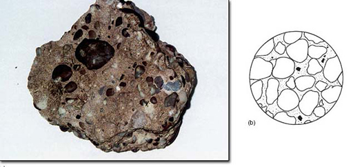
The laying down, or deposition, of layers of rock fragments, mineral grains, or biological material, such as the shells or other hard parts of dead organisms, can produce sedimentary rocks. Once deposited, the loose, unconsolidated sediment may be converted into a solid rock by compaction and cementing of the grains together by chemical action deep below the surface. These rocks consist, therefore, of fragments of sedimentary material, bound together by even smaller fragments, or some sort of cementing material, and so display a fragmental texture, as shown in Figure 7.
1.4.2 Sedimentary processes
Sedimentary grains are formed when the rocks at the Earth's surface are slowly broken up physically by exposure to wind and frost, and decomposed (chemically) by rainwater or biological action. These processes are collectively termed weathering. Once a rock has been broken up by weathering, the small rock fragments and individual mineral grains can be eroded from their place of origin by water, wind or glaciers and transported to be deposited elsewhere as roughly horizontal layers of sediment. The resulting sediment reflects the original rock types that were weathered, the efficiency of erosion and transport, the extents of chemical and physical degradation of the sediment grains during transport, and the conditions under which the grains were deposited from the transporting water, wind or ice. For example, sand-sized grains of quartz are one of the main constituents of sandstone, but those grains may have been transported by water in a river, carried by waves on a sea-shore, or blown around in hot desert sandstorms (to give just three possibilities). How might we distinguish which of the many possibilities is the most likely in any given case?
One approach is to use the size and shape of the grains in a sediment or sedimentary rock to reveal quite a lot about the origin of the sediment. For example, a vigorous river transports much larger grains than a gentle current in a lake, so the size of the grains gives an indication of the strength of the currents that could have transported and deposited the grains. In other words, the grain size depends on the energy of the environment in which the sediment was deposited. The general shape of the grains will tell you about the nature of the transporting medium; for example, was it water or air? (See Box 2, A story in a grain of sand).
Activity 3
Are all sediments composed of fragments of rock and minerals eroded from preexisting rocks?
Answer
No, some sedimentary rocks also contain the remains of dead organisms, i.e. fossils of plants or animals that were living at the time the sedimentary material was deposited.
Any record of ancient life preserved in a rock is known as a fossil – sometimes fossils are rare, whereas a few rocks are composed of virtually nothing else but fossils. In particular, many limestones were formed by the accumulation of the calcite (calcium carbonate – CaCO3) shells and skeletons of certain marine organisms. Chalk is a well-known type of limestone that outcrops extensively across southern England; it is almost pure calcite, and consists largely of minute calcite plates of countless planktonic algae (phytoplankton) fossils. Other limestones, such as those found in the Peak District of northern England, contain abundant fossils of reef-building corals. Another example of a biologically formed sedimentary rock is coal, which is formed from compressed layers of woody plants.
Fossils are important when reconstructing the geological past because they are records of the environment at the time and place the fossil organisms were living. For instance, limestones rich in corals typically indicate warm shallow seas – the conditions needed for a coral reef ecosystem to thrive.
It is important that as many lines of evidence as possible are used to give a consistent interpretation of a rock's origin. No single feature should be taken as unequivocally diagnostic. For instance, think of a desert sand, composed of well-rounded, red oxide-coated, well-sorted quartz grains. Now imagine that climatic conditions change and these sand grains are swept away by flowing rivers and re-deposited elsewhere. The new sand deposit will be produced by the action of flowing water, but the sand grains may retain many of the characteristics of wind-deposition inherited from their previous history. A misleading interpretation can be reached if other lines of evidence are ignored. Such supplementary evidence could come from any fossils in the rock and the nature of adjacent sedimentary layers. Getting all of the necessary information involves a mixture of making observations and measurements at rock exposures in the field as well as examination and analysis of samples in the laboratory.
Box 2 A story in a grain of sand
Quartz is a hard mineral that is very common in the Earth's continental crust. It is resistant to attack by chemicals and physically strong, so it tends to survive the weathering process that disaggregates and decomposes pre-existing rocks. Many sedimentary rocks contain grains of quartz. Quartz grains are recognisable by their glassy appearance (particularly on freshly broken surfaces) and lack of cleavage. Quartz is also hard enough to scratch steel.
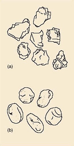
Whether quartz grains are transported and deposited by moving air (by being blown around by the winds in a desert) or by moving water (in a river or in ocean currents) determines how rounded they become (Figure 8). The degree of rounding of quartz grains depends on the intensity and frequency with which grains collide with each other, and these factors depend on the environmental conditions. Air is less viscous than water, so windblown quartz grains collide more violently than quartz grains carried in water, which has a cushioning effect. Also, the wind speeds needed to move a sand grain of given size are higher than the speeds for flowing water. This means that collisions between grains will be much more energetic in air than in water, so the corners of windblown grains are readily knocked off, and the grains are usually very much more rounded (Figure 8b) than water-transported grains (Figure 8a).
Wind-blown sand deposited in desert environments differs from water-lain sand in another way. Quartz sand grains in a desert often have a coating of red or orange iron oxide. This red-orange coloration is typical of desert landscapes and it is derived from the insoluble ‘rusty’ residue from weathering of iron-rich minerals. Water-lain sand grains lack such an obvious coating.
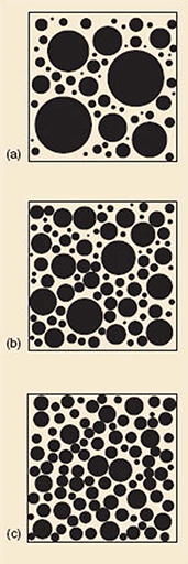
The degree of sorting in a sediment is another useful method for distinguishing different types of depositional situation. Sorting is a measure of the range of grain sizes present in a sediment or sedimentary rock. A poorly-sorted sediment (Figure 9a) has a wide range of grain sizes as a result of rapid deposition, such as occurs during a storm. On the other hand, a well-sorted sediment has a narrow range of grain sizes (Figure 9c), and is the result of extensive reworking of a sediment by wind action in deserts, or wave action on beaches and in shallow shelf seas.
1.4.3 Sedimentary strata
We've seen that the detective work of piecing together a part of Earth's history from sedimentary rocks involves detailed investigation of rock samples, but this can give only a partial picture. On the larger scale of a rock exposure, there can be plenty for us to see and to interpret. Sedimentary rocks are usually found as layers referred to as strata (Figure 10), with each stratum (layer) recording the particular conditions at the time of its deposition. (Note: sedimentary layers are often referred to as beds, but strictly speaking the term ‘bed’ is reserved for those strata thicker than 1 cm; thinner layers are known as laminae (singular lamina).) Over time, conditions may have changed, either gradually or quickly, causing the nature of the sediment being deposited to change. In this way, a vertical stack of sedimentary strata is a record of changing conditions during a segment of geological time. The oldest sediments will be at the bottom, with progressively younger strata laid down on top. Geologists refer to this as the principle of superposition – older rocks are overlain by younger rocks; an individual layer is younger than the one beneath it and older than the one above it; the oldest layer lies at the bottom. This provides a relative time-scale. Changes in sedimentary rocks (or in the types of fossil they may contain) up through a sequence of strata provide a record of changing conditions over the passage of time throughout which the rocks were deposited.
1.4.4 Stratigraphy and geological time
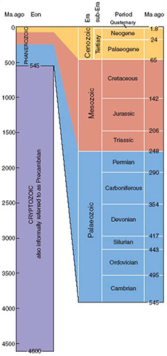
Stratigraphy is the study of how the types of strata have varied over time and also considers how they are distributed geographically. One of the most useful results of stratigraphy is a generalised geological succession – the stratigraphic column – that defines the divisions of geological time. Figure 11 shows the geological time-scale. The broadest division of Earth history is into two intervals (called eons) of very different length: the Cryptozoic Eon and the Phanerozoic Eon. The Cryptozoic is a vast amount of time – from the origin of the Earth, 4 600 million years (Ma, short for mega-annum) ago, to the start of the Phanerozoic, 545 Ma ago. Cryptozoic is derived from Greek words meaning ‘hidden life’. This is the period of time when organisms did not possess hard parts such as shells, so their remains are difficult to find in sedimentary rocks. In contrast, Phanerozoic is derived from Greek words meaning ‘visible life’, reflecting the great abundance of fossils derived from the hard parts of organisms throughout this eon. The Phanerozoic Eon is divided into three eras – the Palaeozoic, Mesozoic and Cenozoic Eras (meaning ‘ancient life’, ‘middle life’, and ‘recent life’, respectively). Each of these eras is divided into a number of periods of unequal length (Figure 11). The current period, which started 1.8 Ma ago, is the Quaternary Period.
Looking at this column, you might think that there is a complete sequence of rocks everywhere, but there is not, in the same way that there are no historical records for certain times from certain areas. In the field, the Earth scientist might find rocks of, say, the Triassic Period lying above and in direct contact with rocks of the Carboniferous Period, so that rock evidence for the Permian Period is not present. This means that either there was no deposition of sediment during the Permian Period, or that these rocks were deposited, and then eroded, before rocks of the Triassic Period were laid down. This type of relationship in the geological rock record, where at a contact there are beds of the intervening age missing, is called an unconformity. The recognition of unconformities in the field is a key part of unravelling the geological history of an area because they represent some sort of hiatus in the conditions at the Earth's surface where the sediments were deposited.
1.4.5 Fossils and ancient environments
An essential component of any environment is the plant and animal life that is adapted to the prevailing conditions. Fossil plants and animals are therefore wonderful sources of information about ancient environments. Plants can leave behind remains ranging from roots, leaves and twigs to seeds and pollen. Leaves and twigs are relatively fragile, and require a comparatively low energy environment (e.g. the mudflats of an estuary) for their preservation. Seeds, pollen and spores are surprisingly robust, and are often the only parts of a plant to survive. Animals can be preserved in one of two ways – either by some part of their body remaining as a fossil, or by some trace, such as the animal's footprints preserved in a muddy sediment, becoming preserved as sedimentary rock (a trace fossil). Even dung can end up fossilised, the resultant fossils being known as coprolites.
Body fossils of animals include shells, skeletal frameworks, bones and teeth. We do not have room here to describe the most common fossil groups.
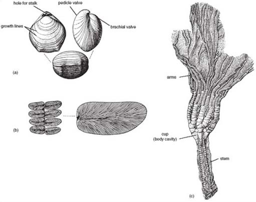
First of all, we have to consider the organism itself. Does it have any hard parts? If not, e.g. a jellyfish, then its chances of fossilisation are very low indeed. However, some soft-bodied organisms burrow into sediment, e.g. the lugworm that leaves the familiar worm casts on the shore, and at least there is the chance that their burrow becomes preserved as a trace fossil. An organism with a one-piece shell, such as a periwinkle or garden snail, stands a better chance of being preserved intact, than if its skeleton is made up of lots of pieces, like a sea urchin or crinoid (Figure 12c).
Activity 4
Which of the following is indicative of deposition in a high-energy environment, and which in a low-energy environment? (a) A sedimentary layer containing complete examples of thin fragile shells. (b) A sedimentary layer containing broken shell fragments.
Answer
For shells to be broken (example (b)) requires a high energy environment, whereas fragile shells can remain intact (example (a)) only if the speed of the transporting and depositing currents are low (i.e. a low energy environment).
Fossils of land-dwelling organisms (e.g. Figure 12b) indicate deposition in or at least near a terrestrial environment, whereas marine fossils indicate a marine environment suitable for the fossil organisms to have lived in (e.g. correct temperature range, light levels, salinity, water depth). This evidence can then be added to evidence from the features of sedimentary grains (Section 1.4.2) to help reconstruct the environment.
1.4.6 Sedimentary structures
Consider some of the places where sedimentary materials are moved and deposited. Are the sediments always laid down in perfectly horizontal, perfectly flat layers? No; as often as not, the depositing surface is not perfectly flat. Instead, a system of parallel ridges, or ripple marks, like the ones shown in Figure 13a, form by the action that flowing water has on the erosion, transport and deposition of sand grains. In sedimentary strata, ripples and dunes (which are effectively larger versions of ripple marks) are normally seen in cross-section rather than in plan view, because pristine depositional surfaces are rarely exposed. In cross-section, the thin sedimentary layers that built up each ripple or dune can be visible, inclined at an angle to the top and bottom of the bed as a whole (Figure 13b). These structures are called cross-stratification and are a clue to the strength, direction and setting of the currents that produced them.
Many features associated with either erosion or deposition in a sedimentary environment can be preserved. For instance desert dunes can yield cross-stratification on a scale measured in many metres. All such structures are referred to as sedimentary structures and, as we have just seen, provide evidence with which to interpret ancient sedimentary environments.
1.5 The formation of metamorphic rocks
Any type of rock can become a metamorphic rock if it is heated to temperatures of several hundred degrees Celsius, and/or if subjected to high pressure (because of the weight of overlying rocks). During metamorphism, the minerals making up the rock become chemically unstable, meaning that their constituent ions are redistributed. The result is that either large crystals grow at the expense of existing smaller ones, or a new set of minerals is formed. Generally speaking, the overall chemical composition of the rock remains about the same. Although igneous and metamorphic rocks both form at high temperatures, an important distinction is that metamorphism occurs in the solid state, whereas igneous activity involves liquid rock (magma).
1.5.1 Causes of metamorphism
Activity 5
What natural process could cause a rock to be heated?
Answer
Heating can be caused when hot magma is intruded into a cool rock.
On the other hand, an increase in both pressure and temperature will come about if the rock becomes more deeply buried as a result of Earth movements, particularly at convergent plate boundaries where continents collide, or is covered by a deepening layer of sedimentary deposits.
There are therefore two settings where metamorphic rocks can be found. In the first, and simplest situation, a narrow zone around the edge of an igneous intrusion becomes heated by the magma and undergoes metamorphic recrystallisation. This is known as contact metamorphism because it is caused by hot magma coming in to contact with cold rocks; contact metamorphism is due to heating alone.
The second common setting of metamorphism is far more extensive, and is caused by the deep burial of crust at continental collision zones. In this setting, huge volumes of rock experience increases in temperature and pressure, causing metamorphism on a regional scale; this is known as regional metamorphism.
1.5.2 Metamorphic recrystallisation
To consider metamorphic recrystallisation at its simplest, let's begin by imagining a sedimentary rock composed entirely of quartz grains – a quartz sandstone. Sandstone is a sedimentary rock and so has a fragmental texture (see Figure 7b). When it is subjected to high temperature and high pressure no new minerals can form because there are no other minerals present with which the quartz grains could react. All that can happen is that the quartz grains recrystallise and the rock known as quartzite is formed. The original fragmental texture is obliterated and replaced by a crystalline texture. Likewise, when a pure limestone, comprising calcite (i.e. CaCO3) is metamorphosed, the calcite recrystallises, and marble is produced. In these cases the rock adjusts to a high pressure or temperature by slowly recrystallising in a denser, more compact, form.
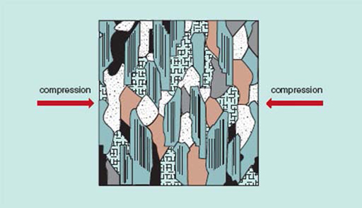
In most cases, however, we start with a rock containing several different minerals, giving a richer chemical mix for metamorphic reactions to work with. At sufficiently high temperature or pressure, the original minerals react with each other, and new mineral crystals grow. In order to do this the constituent atoms must diffuse at different rates through the rock, but diffusion is extremely slow so atoms can move only very small distances in a given amount of time. The chemical rearrangement of the rock therefore entails the growth of small crystals unless the temperature is particularly high, in which case larger crystals can grow. Whenever metamorphism occurs in the compressional environment of continental collision zones (regional metamorphism), the rock is also subject to directed pressure and this also has an effect on the way the minerals crystallise. In the case of the metamorphism of mudrocks, mica crystals are formed during metamorphism. Mica crystals are characteristically platy in shape, which reflects the fact that the atoms in mica are arranged in layers or sheets. When platy minerals grow during metamorphism the energetically most favourable pattern of growth is one in which their flat surfaces lie more or less parallel, and at right angles to the main direction of imposed pressure (Figure 14). Likewise, any elongate crystals grow aligned parallel with each other.
Activity 6
In what way is the metamorphic texture shown in Figure 14 the same as the texture found in igneous rocks (Figure 3) and in what way does it differ?
Answer
The metamorphic rock has a crystalline texture, like igneous rocks. However, it also has mineral layering, or alignment, whereas the crystals in igneous rocks have grown in random directions.
The alignment of platy minerals means that the rock has a series of closely spaced planes of weakness running through it, so it tends to split apart into fairly flat pieces. The rock is said to have a foliation, because its mineral grains are aligned like a stack of leaves (foliage) lying one on top of the other. A classic example is slate, a metamorphic rock with an extremely fine grain size that can be split into thin sheets used for roofing. Slate, and the coarser-grained metamorphic rock schist (pronounced ‘shh-ist’, to rhyme with ‘mist’) (Figure 15) have marked foliation because they contain a lot of mica. But not all metamorphic rocks are as rich in mica. In such cases metamorphism can still produce a banding effect, but here the minerals grow segregated into alternating bands a few millimetres to centimetres thick. Bands of light-coloured minerals alternate with bands of dark-coloured minerals, and the rock is known as gneiss (pronounced ‘nice’). In general, the coarser the grain size of a metamorphic rock, the higher the temperature and/or pressure.
Activity 7
Is the control on grain size in metamorphic rocks the same as in igneous rocks?
Answer
No. In igneous rocks grain size is controlled by cooling rate (and crystals grow from a liquid); the slower the cooling, the coarser the grain size. In metamorphic rocks grain size is controlled by pressure and temperature (and crystals grow by transformation of existing minerals in the solid state); the higher the temperature and pressure, the coarser the grain size.
The end product of metamorphism depends on two main variables – the chemical composition of the starting rock, and the pressure and temperature conditions under which metamorphism occurred. A useful analogy is with cooking – the product of baking in an oven depends on the ingredients that went in (chemical composition) and the temperature that the ingredients were subjected to in the oven. Just as the shape, colour and taste of food from the oven gives us clues about the ingredients and the baking conditions, so the texture and mineralogy of a metamorphic rock allow us to say something about the original rock type and the temperature and pressure conditions in the crust where metamorphism occurred.
Question 3
Compare and contrast contact metamorphism and regional metamorphism in terms of (a) the presence of foliation and (b) the distribution of the affected rocks.
Answer
(a) Rocks formed by regional metamorphism possess a foliation due to the alignment of platy minerals that grew during compression. Rocks formed by contact metamorphism do not show foliation.
(b) Contact metamorphic rocks are confined to a narrow band in the rocks surrounding an igneous intrusion. Regional metamorphism occurs in vast tracts of land as a result of mountain building.
1.6 Interlude
Now that we have covered the features found in igneous, sedimentary and metamorphic rocks, and seen how these features can be explained by the processes that formed the rocks, here is a useful point at which to have a break before continuing with the next section. Before returning, you might like to see for yourself what types of rock you can find in your area. Can you identify their texture, or spot any fossils? Surfaces that haven't been obscured by grime or lichens are by far the best, as it is the attributes of the rock itself, not any later weathering processes that we are interested in. Polished work surfaces, ornamental stones, grave stones and shop fronts are interesting possibilities to start with. And avoid rocks whose grain size is so small that you can't recognise individual grains; a microscope is needed for studying those rocks!
1.7 Geological fieldwork
Although much can be learned from samples of rocks in the laboratory or at home, the ‘natural habitat’ of rocks is outdoors. Here the distribution and layout of different rocks is visible wherever rocks are exposed in places such as stream beds, cliffs, rocky shorelines, quarries, or road cuttings. The exposed rocks can be studied in just the same detail as individual laboratory samples, and geological fieldwork allows the size and extent of each rock unit to be seen and the relationships between them to be observed. This gives us more information from which to deduce the conditions under which the suite of exposed rocks may have formed.
1.7.1 Making and using field sketches
How do we start to make sense of a rock exposure? Drawing a sketch is one of the best ways to start, as it forces you to notice many aspects of the exposure. It also helps you to build up a picture of which aspects are significant and which are incidental or even irrelevant to a geological study. The aim of a field sketch is that it provides a record of your observations (along with notes taken at the same time, and also perhaps a photograph to record details). A sketch is complementary to a photograph because it allows you to highlight and label the significant features. However, your sketch need not be a work of decorative art.
Activity 8 Sketching a geological exposure
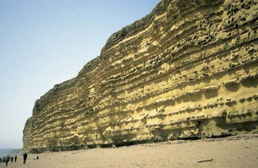
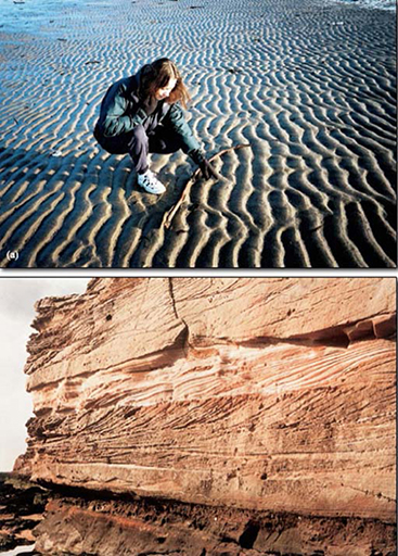
Now look at Figure 16, a photograph of a coastal rock exposure of sedimentary strata. The rock is far from featureless, and we'll explore the visible features by first sketching the exposure, and then working through our sketched observations to develop some ideas about the history of the rocks. Use a pencil, and follow the general guidelines 1–5 below. Spend no more than 15 minutes doing this.
Spend a minute or so looking carefully at the rock face to begin to recognise some general details.
Now it is time to start committing some of your observations to paper! Draw in the skyline and the base of the exposure. (In Figure 16 this extends to the bottom of the photograph.) This marks out the area that you have to concentrate on.
Sketch in the main features using simple lines wherever possible. If necessary, rub out and redraw particular areas until you're happy with them. Part of the skill of making successful geological observations of complex exposures is to follow any key feature (the top or bottom of a sedimentary bed, for instance), as far as you can with your eye until it disappears from view. Similarly, the skill of making an effective geological sketch is to draw a discrete, continuous line (where the feature is continuous), rather than to sketch a vague series of unconnected lines. Ignore shadows from sunlight and features such as loose boulders, fallen branches, etc. You can indicate any patches of vegetation using your own simple symbols for grass, trees, etc.
Label the features you have drawn.
Add a scale, the approximate orientation, for example by marking west on the left and east on the right, and a title including information identifying the location.
Once you have finished, compare your sketch with the one provided in the answer below.
Answer
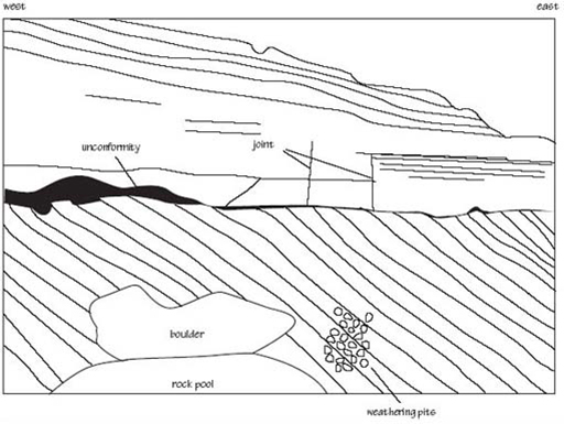
1.7.2 Interpretation of a geological exposure
We now want to make use of the observations obtained by sketching the exposure, and it is useful to start by briefly summarising the features seen. First of all, you probably noticed the large boulder in the foreground of Figure 16 (which has been attached below for ease of access). Where did this boulder come from? It looks to have the same colour as nearby rocks so has most likely come from the same piece of coastline. However, because the boulder is not actually a part of the solid bedrock, we can't rely on it to give a true picture of the local bedrock. Boulders and any other loose rock may have been transported by natural processes or human activities, so geologists usually ignore them when investigating the rocks exposed at the surface. Indeed, much of Britain has been affected by glaciation with the result that the countryside is strewn with large boulders derived from far and wide and transported by moving ice – great for reconstructing the routes of past glaciers, but a shoal of red herrings when trying to investigate the underlying bedrock. We'll therefore ignore the boulder and concentrate on the rocks forming the solid cliffs and foreground.
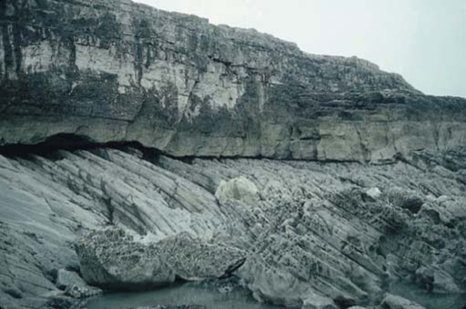
The exposed rocks have sets of parallel lines running through them, and this might have been one of the first things you spotted when taking a careful look at the photograph. These lines define sedimentary layers or strata, so we are dealing with sedimentary rocks. In the rocks forming most of the vertical cliff face, the layers are horizontal, whereas in the white rocks of the foreground the layers are inclined to the right. They are like a tilted stack of books. In this case the strata slope, or dip, to the right at an angle of about 30°. The outcrop has two distinct parts – the upper set of horizontal strata and the lower part of dipping strata.
Looking first at the dipping strata, the sediments appear fairly monotonous, with no obvious change in colour or thickness of individual beds as we pass from left to right. Close up, the rock has a pitted or pock-marked appearance in places (for example the rock face immediately to the right of the large boulder). However, this is a superficial feature caused by weathering of the rock where it is exposed to the elements. The cement holding the sedimentary grains together may not be uniform, such that weathering and erosion take place unevenly, resulting in the weakest spots becoming pockmarked. Although in itself an interesting feature, it is a detail that we won't consider further.
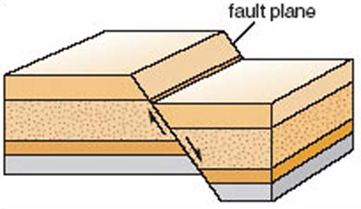
The horizontal strata are also pale in colour, though the vertical cliff that they form has some areas of black and pale green coloration. Rock faces that have been exposed for a long time often become discoloured, owing to chemical weathering or colonisation by lichens and other organisms. In this case, the black coloration is due to biological activity, and the natural colour of the rock is visible in only a few places. Green algae are growing on the lower part of the cliff where wave action provides moisture. When working at the rock exposure an Earth scientist would carefully use a geological hammer to break open the rock and expose a fresh, unweathered, surface in order to find out the true nature of the rock. As well as spotting the fairly continuous horizontal lines defining the horizontal strata (or bedding), you may also have recognised that there are a number of sharp, nearly vertical, ‘cracks’ running through the rocks. These cracks or fractures in the rock are planes of weakness known as joints. The rocks on either side of each joint have not been displaced, and this distinguishes joints from faults. A fault is a fracture across which movement has taken place, such that the rocks on either side of the fault have been systematically shifted up, down or sideways (Figure 17). Joints can form as a mechanical response to the decrease in pressure when deeply buried rocks are exhumed by the erosion of a great thickness of overlying rocks. Faults are formed when rocks break and move because of compression or stretching, with movement on either side of the fault relieving the pent-up compression or tension.
Lastly, let us turn to the junction, or contact, between the lower dipping strata and the upper horizontal strata of Figure 16.
Activity 9
What is the shape of the contact between the dipping and horizontal strata?
Answer
The contact is more or less horizontal, but with some undulations of up to about 1 m in amplitude on the left- and right-hand sides of the exposure. The cliff has become incised owing to preferential erosion along this contact.
1.7.3 Explaining the observations
Having made and reviewed our observations, we are now in a position to interpret them – why are the rocks the way they are? The sedimentary strata that we see in Figure 16 were likely to have been deposited in essentially horizontal layers, so why is one set tilted and the other horizontal? To answer this we need to think about the processes that account for each feature and the relative timings of these processes. So, the strata exposed below the cliff have undergone deposition and tilting. The strata exposed high in the cliff have undergone deposition, but have not been tilted. The rocks with the more complicated history must be the older of the two sets of strata.
A sequence of events that accounts for the observations is as follows.
1. Deposition of sediments as horizontal layers. (Details about the environment in which these strata were deposited could be discovered by closer study of the rocks, using observations of the nature of the grains, sedimentary structure or fossils.
2. Compaction and cementation of the white sediments to form solid sedimentary rock.
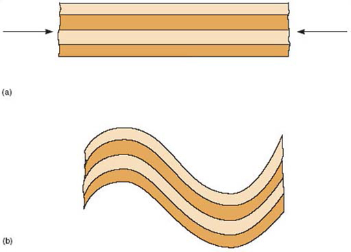
3. Tilting of the white strata. This could have been accomplished by powerful movements in the Earth, involving the rocks being compressed from the sides, to produce folds (Figure 18).
Activity 10
Assuming that the rocks were not completely overturned, in which direction (left or right) would you walk to find the youngest tilted strata?
Answer
The youngest layers lie on top of older layers (the principle of superposition introduced in Section 1.4.3), so these will be to the far right on Figure 16.
4. Weathering and erosion to expose the tilted white strata at the Earth's surface, prior to deposition of the younger strata.
5. Deposition of sediment onto the uneven eroded surface of tilted white strata. The hummocky contact between the two sets of strata that we spotted at the end of Section 1.7.2 is therefore the original land (or sea floor) surface when the younger strata were first deposited.
Activity 11
What term is used to describe the contact between the tilted and horizontal strata?
Answer
It is an unconformity (Section 1.4.4).
6. Compaction and cementation of the younger sediments to form solid sedimentary rock.
7. Formation of vertical joints in the horizontal strata.
8. Erosion to produce the present land surface and coastal exposure.
1.8 The rock cycle
As you are reading this, rocks are being formed and destroyed on the Earth. Rocks are being heated and squeezed to form new metamorphic rocks; other rocks are melting to form magmas, which eventually cool and solidify as new igneous rocks; and the processes of weathering, erosion, transport and deposition are generating new sediments. The continuous action of rock-forming processes means that (given time) any rock in the Earth's crust will become transformed into new types of rock and that these too may in turn be transformed in to yet other rocks. We call this recycling of rock materials the rock cycle.
1.8.1 Moving around the rock cycle
One way of illustrating the possible ways of moving material around the rock cycle is to draw a diagram that places the processes into their geological contexts. Since the rock cycle involves processes occurring on the Earth's surface and also within its interior, we use a cross-section through the Earth's crust and uppermost mantle to do this, as shown in Figure 19. In this diagram we have concentrated on the most common processes within the rock cycle.
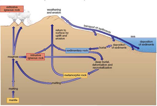
On the grand scale of the Earth, many rock cycle processes occur at plate boundaries, where plates are created or destroyed. For example, the increases in pressure and temperature needed to cause metamorphism in the crust occur in continental collision zones. Metamorphism also occurs in the crust at subduction zones, where rocks get dragged down to great depths and hence experience great pressures. Igneous processes take place wherever melting occurs in the mantle – beneath divergent plate boundaries, above the subducting plate at convergent plate boundaries, and far from plate boundaries at hot spots.
The sedimentary processes of erosion and deposition that are important elements of the rock cycle occur in a great variety of surface environments, such as glacial environments, deserts, and continental shelves. Great rivers, such as the Nile and Mississippi, transport sedimentary material many thousands of kilometres across plate interiors, laying down fertile muddy sediments and modifying the coastline by forming deltas. Other great rivers, such as the Ganges, Indus and Brahmaputra, rise in the high mountain belts where plates are colliding. In these collision zones, plate convergence thrusts mountains into the sky, but the steep mountain slopes and high rainfall encourage weathering and erosion. Consequently, sites of mountain building generate prodigious amounts of sediment, which get washed away to be deposited elsewhere. For example, the Bay of Bengal contains several million cubic kilometres of sediment derived from the Himalayan mountains. The fate of sediments is to be eroded and redeposited, or to be turned into sedimentary rocks. Those rocks can then be caught up in subduction zones, either entering the mantle, being forced onto the edge of a continental plate, or being trapped and metamorphosed in a continental collision.
Although the rock cycle moulds the geology of the crust, it does not operate in isolation. The weathering of rock is influenced by climatic effects. The transport and deposition of sediment varies according to the strength of water currents, wind speed or glacial action. The rock cycle is also greatly influenced by organisms. An obvious example is the formation of limestones from corals and other organisms, which form calcium carbonate skeletons or protective structures. Another way in which organisms affect the rock cycle is through weathering. Rocks are partly broken down by the physical action of wind and frost, and by chemical decomposition by rainwater containing dissolved carbon dioxide, but this is greatly accelerated by plant roots, micro-organisms, and other living things in the soil.
1.9 Changing sea-level
Sedimentary rocks reveal how environmental conditions in Britain's geological past were extremely different from those of the present day (in fact ‘Britain’, like the rest of the Earth's geography is transitory when viewed in terms of the very long span of geological time). As well as evidence from sedimentary rocks, recent landforms also indicate that in the more recent geological past (within the Quaternary Period), sea-level was not the same as it is at present.
Activity 12
What deposits could we look for that might suggest that sea-level was once higher than at present?
Answer
Beaches today generally have a mixture of pebbles or sand, along with shells and shell fragments. So, if we found such a deposit perched on a cliff above the present high-water mark, we could infer that since it was deposited, there has been a fall in sea-level, leaving behind a raised beach.
Raised beaches, sometimes backed by an ancient cliff line, are common features around Britain's coast. Before explaining this observation, we need to ask ourselves has the sea-level fallen, or has the land risen? Both are feasible. For instance, sea-level can fall relative to a fixed landmass if the volume of the oceans shrinks due to cooling and the formation of land-based ice-caps. Similarly, it will rise if these ice caps melt. It so happens that since 2 to 3 million years ago the Earth has been experiencing an ice age – a prolonged period of alternating glacial and interglacial periods characterised by the presence and absence of large polar ice-caps. We are living in an interglacial period that became established about 10 000 years ago. As the volume of ice increases and decreases throughout an ice age, so the volume of the oceans decreases and increases. Some raised shorelines can therefore date from a previous interglacial period when the ocean volume was larger, and hence sea-level was higher than today's.
Nature is not quite so straightforward, however, because the development and removal of thick ice sheets on land surfaces has an effect on the elevation of the land, relative to sea-level. In the last glacial period much of Britain was covered by an ice sheet up to 1.5 km thick for some 60 000 years. As this ice sheet melted, Britain was relieved of the enormous weight of the ice sheet, allowing the land to ‘bounce back’ in the manner of a ship rising out of the water when a heavy cargo is unloaded, with the result that the land moved relative to sea-level, producing raised shorelines. A complex interplay of changing climate and Earth movements is therefore involved in producing many of the geologically recent coastal landforms of the British Isles. In addition, we can remark that concerns about contemporary sea-level rise relate to yet a further process – that of rapid ocean warming accompanied by the expansion of seawater volume.
1.10 Summary
Rocks are classified into three types according to how they were formed. Igneous rocks are formed by crystallisation from the molten state; sedimentary rocks are deposited at the Earth's surface from water, air or ice; and metamorphic rocks are rocks of any origin that have been subsequently transformed (metamorphosed) by heat and/or pressure, often several kilometres below the Earth's surface.
Rocks are generally either crystalline, i.e. formed of interlocking mineral crystals, or fragmental, i.e. formed of mineral or rock fragments compacted and cemented together by later mineral growth. Most igneous and metamorphic rocks are crystalline whereas most sedimentary rocks are fragmental. Most metamorphic rocks have a foliation or mineral banding, and this distinguishes them from igneous rocks. The presence of fossils usually indicates a sedimentary rock.
Slowly cooled magmas produce large crystals, whereas rapidly cooled magmas produce small crystals. The grain size of an igneous rock is therefore an indication of cooling rate. Igneous rocks are classified according to grain size and the minerals present.
Metamorphic rocks may be produced around the margins of igneous intrusions (contact metamorphism) or throughout large volumes of rock in mountain building events where continental plates collide (regional metamorphism). Regional metamorphism produces foliated or banded rocks, whose grain size increases with increasing pressure and temperature (depth).
The surface environment in which a given sedimentary rock formed can be deduced from the character of the sedimentary grains and the types of any fossils and sedimentary structures present. For example, a large grain size indicates that the energy of the depositional environment was high. Well-sorted, well-rounded grains indicate deposition from the air (wind transport) whereas water-laid sediments have poorer sorting and less rounded grains.
Exposures of rocks display the relationships between different rock types and the arrangement in space of those rocks. This gives additional information about how the exposed rocks were formed. The subsequent geological history can be deduced by identifying evidence for geological events that have altered earlier rocks (for example, folding will tilt originally horizontal beds, faulting will offset originally continuous beds, and a break in sedimentation will give an unconformity).
Sedimentary, metamorphic and igneous rocks are produced within a continuously operating cycle – the rock cycle – which is the path taken by Earth materials in response to chemical, biological and physical changes acting on rocks. Those parts of the rock cycle that produce new sedimentary rocks involve the weathering and erosion of pre-existing rocks, followed by transport and deposition of eroded mineral grains and rock fragments. Certain other sedimentary rocks are formed by biological processes, such as the accumulation of shells. In both cases these processes occur on the surface of the Earth. Most igneous and metamorphic rocks are produced near lithospheric plate boundaries.
The presence of raised beaches is evidence of geologically recent sea level change. The processes involved are a combination of climatically-influenced growth or melting of ice-caps and uplift of land in response to unloading when ice sheets are removed by melting.
2 What is ecology?
Ecology is usually defined as the study of organisms in their environments. In its broadest sense this definition includes the way we, the human species (Homo sapiens), interact with and use the environment. However, in the sense in which most ecologists work, ecological studies are limited to studies of the ways plants and animals interact with each other and with their physical environment, and hence survive in natural and semi-natural habitats. The ways in which the human species affect the environment – for instance, by polluting the air, growing crops, digging peat, eroding the landscape or even extracting water – form part of the study of the factors that affect other organisms.
2.1 Why study ecology?
These days, bird watching is a popular leisure activity and in the past so were collecting insects, wild flowers and birds’ eggs (although such activities are not now recommended – indeed, they are often illegal – because of the potential damage they cause to flora and fauna). Some amateurs are or were truly experts in their fields. In fact, much of the original identification of the British flora and fauna was done by amateur naturalists. Many a Victorian vicar or other self-taught naturalist contributed to the specialist knowledge available to, and used by, professional biologists today. And though ‘high-tech’ techniques are often used by professionals, many aspects of ecology can be studied with comparatively simple and limited equipment – provided one has time and patience.
Stories of environmental damage appear fairly frequently in the national press. Peat extraction (gardeners are now encouraged to use composts that do not have a peat base) and pollution of air and water are frequently highlighted. Such events have marked effects on local plant and animal populations by killing off organisms, or in the case of peat extraction, by eliminating whole habitats from a local area. Is this important?
There are obviously aesthetic reasons for preserving threatened habitats; diversity of landscape forms is pleasing to the eye – for instance, that created by hedgerows along roadsides and between fields, or by small woodlands. The general public usually appreciates this argument even when an ecologist's view, that maintaining the diversity of organisms and habitat is important for its own sake, is not accepted so readily. Preservation of different habitats in the landscape is closely associated with maintaining biodiversity and the healthy perpetuation of the flora and fauna, including rare species.
In many cases reduction of numbers leading to the elimination of organisms is an indicator that ecologically something has gone badly wrong. In time, this may even adversely affect the human population.
Figure 20 shows the number of species of lichens and bryophytes (i.e. mosses and liverworts) growing on trees and on walls at different distances westward (i.e. towards the prevailing wind) from the centre of Newcastle upon Tyne.
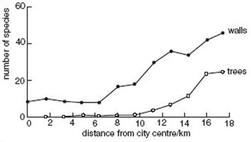
Table 2 gives the annual atmospheric sulfur dioxide (formula SO2) concentrations along a transect north-west from Newcastle upon Tyne city centre at about the time that these data were collected.
| Distance from city centre/km | SO2 concentration/g m−3 |
|---|---|
| 0 | 200 |
| 2.5 | 160 |
| 8 | 65 |
| 90 | 65 |
Question 4
From the information in Figure 20 and Table 2, describe the likely effect of SO2 pollution of the air on the growth of lichens and bryophytes.
Answer
The numbers of lichen and bryophyte species appear to decline with increasing SO2 pollution. (All we can state for certain is that numbers of lichen and bryophyte species decline and SO2 pollution increases as Newcastle upon Tyne city centre is approached.)
Question 5
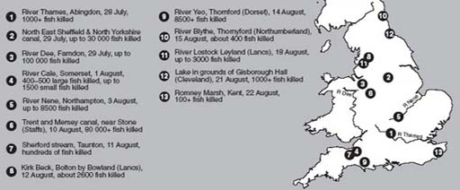
Similarly, extreme levels of water pollution are often accompanied by fish deaths (Figure 21). Do you think that other organisms were killed, or only fish?
Answer
It is reasonable to expect that water pollution will kill other animals and plants.
With increasing levels of pollution – whether of air or of water – there is likely to be a gradual reduction in the population sizes, and eventually complete elimination, of species that are more susceptible to pollution.
Using the presence/absence and population sizes of organisms such as freshwater invertebrates that are typical of habitats with different characteristics, biotic indices measuring pollution levels can be constructed. Such animals are easy to use as indicators of the level of damage, as an expert can quickly assess which species are present using simple collection techniques and also estimate their numbers.
If we do not understand the reasons why different habitats continue to function, why organisms occur where they do, and why they increase or decline in numbers, it is impossible to identify or conserve threatened species. At the same time it is often not possible to make judgements on environmental issues affecting humans.
But why not leave such matters to the professionals? Why learn about how ecologists work? There certainly seems to be increasing concern about the soundness of much environmental decision-making. If you, as a member of the public, are to make valid judgements about information released in the press, you usually need some knowledge about the subject and especially about the ways in which data are collected and their reliability.
2.2 Two factors affecting the distribution of organisms
We will illustrate some of the complexities of interpreting ecological field data by looking at two sets of environmental factors, soil pH and salinity, desiccation and biotic interactions on sea-shores.
2.2.1 Soil pH
pH (a measure of acidity or alkalinity) is an important environmental factor, particularly in soils. Soil is derived partly from accumulated decaying vegetation and partly from broken up fragments of the underlying rocks. Soil pH is determined by both these components and also by the water that fills the spaces between solid soil particles.
How might you expect the pH of soil overlying limestone (or chalk, which is a particular form of limestone) to compare with that of soil overlying sandstone? The soils would have different pH values. Limestone is a calcareous rock rich in carbonates (usually calcite), which gives rise to soils of pH of 7 and above. Sandstones contain much silica and so give rise to neutral or slightly acid soils, where the pH can be as low as 3.5.
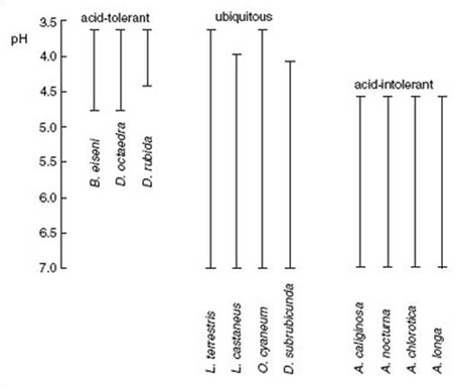
Figure 22 shows the distribution of earthworm species in soils of different pH. You can see that some species have wide pH tolerances, whereas others have much narrower ranges, being specialist species of either acidic or more neutral soils. Species of plants and animals that are found only in alkaline environments are termed calcicoles (i.e. organisms that like a calcium-rich environment), whereas those that dislike these soils are called calcifuges (i.e. calcium escapers).
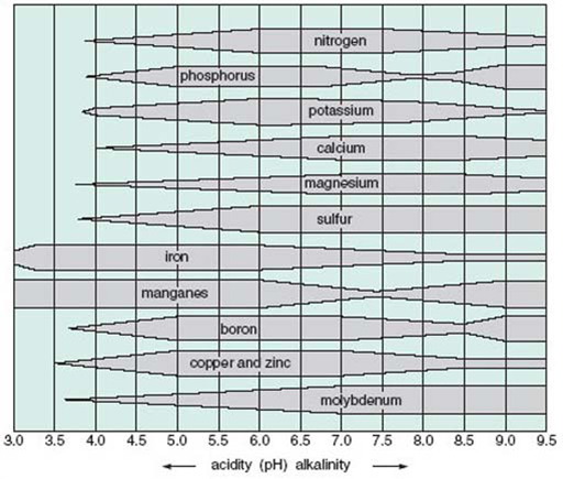
pH is a critical factor for plants, if only because it affects the solubility of mineral nutrients and hence their availability to plants. Figure 23 shows, in the form of ‘kite’ diagrams, the relative availability of several minerals at different pH values. A mineral is most available at pH values where its ‘kite’ is widest and least available where its ‘kite’ is narrowest or non-existent.
Question 6
Which minerals are most available, and which are least available, (a) at pH 7.5–8.5 and (b) at pH 3.5–4.5?
Answer
(a) At pH 7.5–8.5, molybdenum and sulfur are most available, whereas iron and phosphorus are least available. (Fair amounts of magnesium, calcium and nitrogen are also available, but there is comparatively little boron, copper, zinc or manganese.)
(b) In very acid soils of pH 3.5–4.5, manganese and iron are most available, but hardly any of the other minerals listed are available in significant amounts.
Where minerals are absent at low pH, it is often the result of their high solubility in water at these pH values. As a consequence, they move down through the soil dissolved in water (i.e. they are leached) and so are taken into groundwater well below the level of plant roots. In contrast, phosphorus, manganese and boron are locked up in insoluble iron and aluminium phosphates at around pH 7.5. Plants growing on these soils can suffer from deficiency diseases (for example, phosphorus deficiency, which shows as yellowing of the leaves). This is particularly true of plants that are not adapted to grow at high pH. Phosphorus is also unavailable at low pH; again it is locked up as insoluble aluminium phosphate.
Limestone-derived soils may have very high pH values – 8 or above – particularly where the soil is shallow and directly overlies carbonate rock. Very few acid grasslands have a pH as low as 4.5. However, low pH values are a feature of moorlands characterised by heather (Calluna vulgaris) and bracken (Pteridium aquilinum), and also of upland bogs characterised by rushes (Juncus spp.) and cotton sedge (Eriophorum vaginatum), where the pH can be below 5.5.
The reasons why plants show preferences for acid or alkaline soils are not always simple, i.e. attributable solely to nutrient availability. For instance, some minerals can be toxic. Thus calcicoles grown on acid soils suffer from aluminium and other toxicities that cause stunting of their root systems. This stunting reduces nutrient uptake as a secondary effect.
2.2.2 Salinity, desiccation and biotic interactions on seashores
Tidal movements ensure that sea-shore habitats are, if not covered by seawater for part of each day, at least subject to spray-borne salt and wind. So, even well above the level of high tides, sea-shore organisms need to be more tolerant of salt than most terrestrial organisms. However, salinity (the concentration of salts dissolved in water) is not the only factor affecting sea-shore species. Seaweeds and shelled animals like limpets and barnacles are adapted to living in a highly saline marine environment, but they suffer desiccation if they are out of water for too long between high tides. In addition, where the shore is in an exposed location (i.e. a high energy environment), sea-shore organisms need to be able to tolerate severe abrasion caused by both wave action and pebble movements.
These factors affect not only which species are present in the intertidal zone, but also their exact location on the shore, i.e. their zonation. The pattern of zonation that results from these environmental factors is then further modified as the result of biotic interactions between organisms, such as seaweeds and the molluscs that graze on them. So, patterns of zonation vary and interpretation of what is found can be rather complicated.
Figure 24 shows the zonation pattern of seaweeds and grazing animals on two rocky shores.
Question 7
Describe the differences between the occurrence and zonation of channelled wrack (Pelvetia canaliculata) and limpets (Patella spp.) on these two shores.
Answer
Channelled wrack does not occur on very exposed shores. Limpets occur on both sheltered and exposed shores, where they show roughly the same upper limit of distribution. However, limpets extend farther down the shore in exposed habitats.
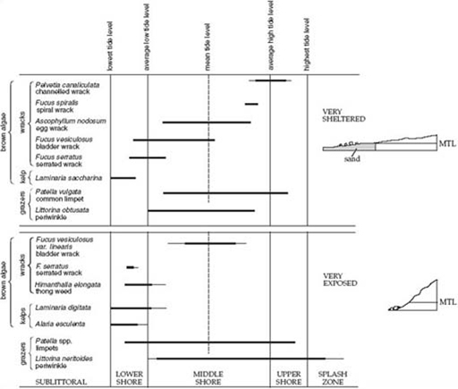
Click to see larger version of image
Channelled wrack is a species that is very resistant to desiccation and can recover even when it loses 96% of its water content. However, it has a relatively low growth rate and so it may not be able to become established on shores where young plants would be damaged by wave action. Other factors affecting the growth and zonation of channelled wrack include its inability to tolerate low light levels (for instance, when covered by the more profuse growth of other seaweeds) and its susceptibility to disease when submerged in water for long periods of time.
Limpet distribution on the lower reaches of sheltered shores is linked to the heavy growth of brown seaweeds, such as wracks and kelps. When juvenile limpets (spat) are released into seawater they must settle on rock surfaces to develop further. If no rock surfaces are exposed there is no place for them to settle.
Question 8
How could the salinity of the environment increase when tides recede and organisms are left exposed?
Answer
As exposed surfaces and organisms lose water by evaporation, the concentration of salt in the remaining water increases.
It follows that organisms occurring in the spray zone, above the level of high tides, may have to cope with an environment in which salinity can sometimes be higher than further down the shore, where the tide is out for only a limited time. However, at other times rainfall can reduce the salinity experienced by these organisms to below that of seawater.
2.3 Starting a field study
When you go to somewhere that is new to you, and of which you know very little, you should have a plan of action to help you to put together a scientific description of the site. Fairly obviously, one of the things you would do is to note the location and make a description of what you are able to see. This might be in the form of a sketch map. It might also include producing a species list of the plants and animals found in the site. However, to make a complete species list might take days, weeks or even years, depending on the size of the site. One way round this is to make a list of the most common or dominant species. With time you might add the names of less common, yet fairly frequent species. With even more searching, the species that are only occasional can be added. In doing this you would be making subjective judgements, i.e. judgements that are qualitative and do not require the collection of quantitative information. But subjective assessments can be misleading. For instance, you might be influenced by the ‘attractiveness’ of a species, the prominence of its location or simply through bias, that is finding what you think you ought to find. In the long run, as a field scientist, it is important to collect quantitative data that ensure an unbiased assessment and description of the location. It is also often important to be able to describe a site over a relatively short time-scale.
Figure 25 is a sketch map of a deciduous woodland site. Figure 26 is a profile of the site showing its topography along the line marked A to B. You can see that part of the wood is on top of a small hill, part is on a slope and part is on a flatter area at the bottom of the slope. A small stream runs along the base of the slope. Is the woodland a uniform habitat? One way of testing this out is to walk along the line A to B (technically this would be called a transect), noting whether the tree species that you see are the same throughout. Let us assume for the moment that they fall into three groups (Figure 27). Ashes and oaks (Figure 28b and d) dominate on the flat land at the top of the hill, oaks and birches (Figure 28c) dominate on the slope, and alders (Figure 28a) and birches along the narrow stream-side strip and on the flat area beyond. If these three areas really are distinct, it would be safe to survey each of them as if they were separate habitats. But to ensure that there was no bias in your data collection, your three areas should be sampled randomly. If the changes between the top and bottom of the hill are gradual, in other words if it is not easy to see where one habitat ends and another begins, then you need to sample at intervals right along the transect.
Woodland is usually a multi-layered (i.e. three-dimensional) habitat, with tall trees forming the tree layer, small trees forming the understorey and low-growing shrubs and herbaceous plants forming the ground layer. Figure 27 is a profile of these three layers along the transect A–B. The key tells you that, at the top of the hill, the understorey includes holly (Ilex aquifolium); however, this species does not occur on the slope or at the foot of the hill. Similarly, the ground layer at the top of the hill is thick with bluebells (Hyacinthoides non-scripta) in spring but these do not occur on the slope or at the foot of the hill. Near the stream there are big clumps of one of the tall grass-like sedges (Carex spp.). From plant distributions in either the tree or the ground layer it is reasonable to propose that the three sections of the profile are different. If you think you can differentiate between areas, it is reasonable to think they may be different habitats and therefore they should be described individually. You can, however, provide better evidence of this by collecting quantitative data.
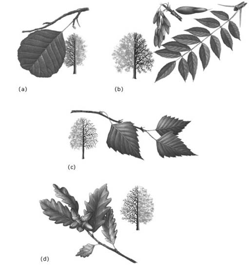
Question 9
Figure 29 is a profile of the vegetation in a spruce plantation. (a) Describe how the vegetation (other than the trees themselves) differs from the profile of deciduous woodland (Figure 27). (b) How could you account for the differences?
Answer
(a) There are no understorey or ground layers.
(b) One possibility is that the tree canopy is so dense throughout the year in the spruce plantation that hardly any light penetrates to the ground layer, whereas there are times of the year when light can penetrate through the tree canopy in deciduous woodland.
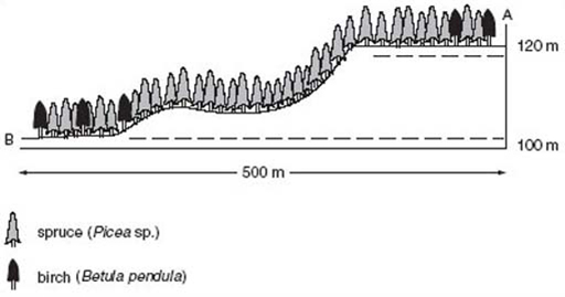
Most habitats are three-dimensional to some extent, although the scale may not be as noticeable as it is in deciduous woodland. Garden lawns, for instance, may well have a close ground-hugging moss layer under the grass and this can become dominant, to the annoyance of the lawn-keeper, if the soil becomes compacted and hence poorly aerated.
2.4 Collecting quantitative data
How can you collect quantitative data that summarise the nature of a habitat when it is three-dimensional? How, in fact, do you collect quantitative data?
Multi-storied habitats where the components have a different scale are usually recorded storey by storey, but using much the same methodology. There are two standard ways of collecting data quantitatively. The first involves recording species present within a standard area such as 10 cm × 10 cm, 0.5 m × 0.5 m, 1 m × 1 m, or 10 m × 10 m. It's all a matter of scale: 1 m × 1 m or smaller would be used as the unit for recording species in the ground layer whereas 10 m × 10 m would be used to record trees. Any device used for this purpose, whether it is one or more tape measures or a wooden frame, is called a quadrat. Within individual quadrats it is often possible to record the actual numbers of each species, or their presence or absence within each of a number of quadrats to show their frequency. Alternatively, the area occupied by each species can be recorded to give cover measurements.
A modification of the square quadrat that is more accurate – so particularly useful in habitats that have long lists of species – is the point quadrat. In such environments, sorting out which species are present (and especially the area they occupy) in even a 0.5 m × 0.5 m quadrat can be very laborious. Point quadrats are, in essence, minimal area quadrats. Each species touched by a sampling pin as it passes through the vegetation before reaching the soil surface is recorded as being present at that point.
An alternative to area counts is time counts, i.e. recording the number of organisms seen in a set period of time (e.g. 1 or 5 minutes) (assuming that diligence does not alter!). It may not surprise you that this method is generally used to record numbers of organisms that move around. Thus, flying insects can be collected in a sweep net which is moved back and forward as the collector walks onward for a given time. Ground-living, but mobile, insects such as beetles or slugs can be collected in submerged traps that the researcher visits once or twice a day. Woodland mammals, such as mice, voles, squirrels and stoats, are collected in traps that close upon the animal when they enter it (bedding and food must be available while the mammal remains trapped because recording should never be allowed to affect the size of the population). Numbers of relatively sedentary animals (such as snails and limpets) can be counted using either area or time counts.
Question 10
(a) How would you record data about species present and their numbers in (i) the tree layer of a woodland and (ii) a moss layer of a lawn?
(b) How could you determine the frequency and distribution of greenfly in a garden?
Answer
(a) 10 m × 10 m quadrats would probably be appropriate for recording tree species and numbers in a woodland. The moss layer in a lawn could be recorded using quadrats as small as 10 cm × 10 cm (mosses are much smaller than flowering plants and grasses).
(b) Greenfly spend a lot of their life with their mouth parts stuck inside plants, but they are mobile for periods of time. When attached they can be counted per unit area, but when they are mobile, traps and timed samples are appropriate.
One of the last questions that needs to be resolved in the field is how you would know whether you had collected enough data to have a reasonably reliable picture of the organisms present and their relative numbers. The number of replicate samples made depends entirely on the variability within the habitat. If there are many species you need more replicates to get reliable results, i.e. results that tell you which organisms are truly ‘dominant’, ‘frequent’ or ‘occasional’.
Conclusion
Ecology is the study of the interactions between organisms and their environment (including other organisms). An understanding of ecology is important to inform environmental decision-making.
Soil pH influences the availability of mineral nutrients to plants and hence the distribution of different plant species. Some species may be classified as either calcicoles or calcifuges.
Variation in salinity, exposure to desiccation and biotic interactions (e.g. grazing) influence the zonation of seaweeds and animals on rocky shores.
Field studies usually involve the collection of quantitative data in as objective a way as possible. Transects are often taken across field sites where some sort of environmental gradient is suspected. Quadrats at various scales, including point quadrats, are used to estimate frequency or the proportion of area occupied by different plant species. Time counts may be used to sample organisms that move.
Keep on learning

Study another free course
There are more than 800 courses on OpenLearn for you to choose from on a range of subjects.
Find out more about all our free courses.
Take your studies further
Find out more about studying with The Open University by visiting our online prospectus.
If you are new to university study, you may be interested in our Access Courses or Certificates.
For reference, full URLs to pages listed above:
OpenLearn – www.open.edu/ openlearn/ free-courses
Visiting our online prospectus – www.open.ac.uk/ courses
Access Courses – www.open.ac.uk/ courses/ do-it/ access
Certificates – www.open.ac.uk/ courses/ certificates-he
Newsletter – www.open.edu/ openlearn/ about-openlearn/ subscribe-the-openlearn-newsletter
Acknowledgements
The content acknowledged below is Proprietary (see terms and conditions) and is used under licence.
Grateful acknowledgement is made to the following sources for permission to reproduce material in this course:
Course image: Stephane Venne in Flickr made available under Creative Commons Attribution-NonCommercial-ShareAlike 2.0 Licence.
The content acknowledged below is Proprietary and is used under licence.
Figure 1 IPR/15-22, reproduced b permission of the British Geological Survey. © NERC. All rights reserved;
Figure 10 & 16 Courtesy of Peter Sheldon;
Figure 12a & c British Mesozoic Fossils, 4th edn, © Trustees of the British Museum (Natural History) 1872;
Figure 12b British Palaeozoic Fossils, 3rd edn, © Trustees of the British Museum (Natural History) 1969;
Figure 28 Goldstein, M. et al. (1990) Complete Guide to Trees and Their Identification, MacDonald & Co. (Publishers) Limited.
All other written material contained within this course originated at the Open University
Don't miss out:
If reading this text has inspired you to learn more, you may be interested in joining the millions of people who discover our free learning resources and qualifications by visiting The Open University - www.open.edu/ openlearn/ free-courses