

1.4 Enter the historians
All these cultural trends generated cultural products (maps, drawings, descriptions) which are, in themselves, evidence of socio-economic developments and power relations. After all, a person had to be very rich to acquire an estate of land and only the well-off had the money and time to purchase and read travel literature. These products became primary source evidence for historians but also established a tradition of working on and in a landscape, observing and collecting material. Hoskins’ landmark book began a branch and a tradition of academic history and encouraged landscape, local and urban historians to go outside, to explore their place of study and to use their environment as evidence.
In the 1950s and 1960s historians like Hoskins, Joan Thirsk and Emyr Estyn Evans pioneered studies of rural landscapes and communities while Jack Simmons, H.J. Dyos and Asa Briggs developed further sub-fields or disciplines, including transport history and urban history. They were all united by a tradition of examining the environment around them and interpreting it as material evidence of the past. In the words of Asa Briggs: ‘There is no substitute for knowing a city: reading about it is second-best’ (1993, p. 12). The method of walking, observing and ‘knowing’ the environment also links these historians back to the map-makers, travel writers and antiquarians in the past who sought to know and explain the world they saw. Here you can see that increasingly diverse fields of academic history have developed their own traditions of scholarly research practice and literature (historiography) over the last half a century or so but are also rooted in a broader cultural context.
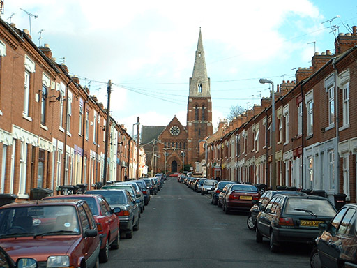
The economic and urban historian Richard Rodger studies the built environment today and shows how walking through streets and looking up can reveal evidence of migration and everyday life in the Victorian city:
Almost half the plaques recorded on Leicester terraced houses referred to Midlands towns and villages. Most numerous, perhaps predictably, were those from Leicestershire (18 per cent); contiguous counties accounted for 16 per cent of the place names recorded. This might be considered to chime with step migrations that stress sequential short distance moves from villages to small towns and then to cities, and this portability of place names warrants further research on Leicester and elsewhere as a means of understanding the role of nostalgia and the search for and significance of emotional connections for urban newcomers.
Like the antiquarians before them, landscape historians may walk, draw and map a locality (rural or urban); they might also photograph or film it or use digital satellite technology (GIS) to map, record and measure accurately. New technologies aid historical research which has grown from a long tradition of wider knowledge construction and a more recent tradition of academic landscape history. Better understanding of the impacts of human activity on landscapes has seen environmental history grow in scale and importance in the twenty-first century. While antiquarians preserved ancient monuments, today’s historians can be active in local and civic history initiatives including public history and conservation activity. Modern academic landscape, urban and environmental history has expanded to include the history of conservation and environmental protest which have their roots in the nineteenth century.