Managing coastal environments
Use 'Print preview' to check the number of pages and printer settings.
Print functionality varies between browsers.
Printable page generated Monday, 27 July 2026, 10:05 PM
Managing coastal environments
Introduction
We begin this course by looking at an estuary, a place where sea, land and sky meet. We have chosen a particular estuary: the Blackwater estuary on the Essex coast in eastern England. Although the Blackwater has its own unique characteristics, it is used here as a setting, a device for approaching the study of environments. Like any other estuary, the Blackwater brings together a diverse range of processes, elements and issues that constitute the environment. It offers us a way into thinking about how to approach the study of environments and why environmental questions are so pressing. By drawing on a variety of examples from the estuary we intend to convey how broad the study of environments can be; rather than focusing on a particular issue, this course is an introduction to the study of environments.
This OpenLearn course provides a sample of Level 1 study in Enviromental Science.
Learning outcomes
After studying this course, you should be able to:
recognise the interaction of human and physical processes in the making of environments and the understanding of environmental issues
understand coastal regions as dynamic and contested environments
consider the contested nature of coastal management policies using the case study of managed retreat.
1 An estuary – where the elements meet
1.1 The Blackwater estuary
‘Between the mouths of the Blackwater and the Colne, on the east coast of Essex, lies an extensive, marshy tract veined and freckled in every part with water. At high tides the appearance is that of a vast surface of Sargasso weed floating on the sea, with rents and patches of shining water traversing and dappling it in all directions. The creeks, some of considerable length and breadth, extend many miles inland, and are arteries whence branches out a fibrous tissue of smaller channels, flushed with water twice in twenty-four hours. At noontides, and especially at the equinoxes, the sea asserts its royalty over this vast region.’
Revd Sabine Baring-Gould, Mehalah, 1983 (first published 1880)
Before reading any further, click below to view an introduction to the dynamic physical and human history of this coastal environment. Watch the video clip and keep in mind that coastal environments are all about change.
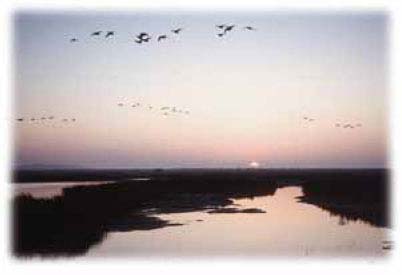
Imagine you are standing on the shore looking south out across the mouth of the Blackwater estuary (viewpoint in Figure 1). What do you see? Perhaps, at first, you take in the general scene, the setting. In front is the broad sweep of the river, which stretches from far upstream to where it first reaches the tide at Maldon and merges with the North Sea. Beyond, on the opposite shore, is the low-lying Dengie peninsula (Figure 2). Around you are the beach, saltmarsh and clay that make up the landscape surrounding the estuary. And above is the vast East Anglian sky, its importance in the scene emphasized by the flat country and sea all around (Figure 2). Here then, we have the three fundamental elements – using the term ‘element’ in the traditional sense of earth, water and air – the components that comprise the natural surroundings or environment, the biosphere (that part of the Earth capable of supporting life).
Click here to view, 'The Blackwater estuary, on the east coast of England, adapted from the Blackwater Estuary Management Plan'.
Click here to view, 'The Blackwater estuary in the late eighteenth century: a map of the County of Essex from an actual survey by John Chapman and Peter Andre, 1777. The illustration has been compiled from eighteenth-century maps in the Essex Record Office'.
Though the elements may be viewed as separate, they are also interlinked through various social and natural processes. Water, for example, which is present not only in the estuary but also on and in the land and as water vapour and droplets in the atmosphere, does not just stay in any one of these three elements but can also move between them.
Box 1: The hydrological cycle
Water in the estuary can transfer to the atmosphere by evaporation from the water surface. Water in the atmosphere can fall on either the land or estuary as precipitation. From the land, rivers can move water to the estuary, and water on land can move through the land as groundwater and also evaporate from the surface or from the pores in leaves of vegetation to the atmosphere (a process called transpiration). This cyclic movement of water is called the hydrological cycle, or water cycle.
The scene before us is not static; it is one of ceaseless movement, not all of it evident to the human eye. There is the changing weather, sometimes creating spectacular storms that alter the shape of the coastline. There is the ebb and flow of the tides, revealing, at low tide, the gravel and muds of the foreshore. There is also the movement of life: the sea teems with fish and other sea creatures, including the oysters that are famous from this part of the world. The mudflats, too, support abundant life, and many of the species found here occur only in estuaries. It has been calculated that one square metre of mud can hold 1,200 worms, while 15,000 snails (Hydrobia ulvae) can graze on its surface. The saltmarsh forms a coastal ecosystem here with a rich variety of ecosystem salt-tolerant plants (Figure 4). Above, there is the movement of flocks of birds along this important migratory highway (the so-called Eastern Atlantic Flyway).
Box 2: Ecosystems
The term ecosystem was first coined by Arthur Tansley (1935) to describe the interdependent groupings of plants, animals and other living organisms as well as inanimate components (such as water, soil minerals, etc.). All of these things use energy and process materials to produce the communities and landscapes that we see in the world around us. In ecology, the term has become associated with a particular approach to the study of the interactions among living organisms, an approach that concentrates on energy and material exchanges. However, it is also used more colloquially to refer to any area or grouping of organisms that can be regarded as functionally interdependent. An ecosystem in this sense can be of any size, from an isolated clump of mossy vegetation on a rock, to the whole thin layer around the world in which life occurs, the biosphere.
The estuary is never the same. It is always evolving, changing and recomposing. The environment is dynamic. It is a composition of rhythmic processes, of living movement and, from time to time, of sudden change. This feature of changing environments is the first major theme we shall be using in this course and the series as a whole to help you approach your studies. We shall return to this theme in terms of the estuary in a moment.
What other features compose the present scene? Across the estuary, near the tip of the Dengie peninsula, we can see the modest outline of the seventh-century St. Peter's Chapel. The Chapel is near the site of a Roman fort, testimony to the long period of human habitation in the area. About two miles to the west is the bulk of Bradwell nuclear power station, a twentieth-century edifice that provided electricity for 40 years (until 2002) and that will pose the risk of radioactivity leaking into the surrounding area for decades to come. On the water are the local fishing vessels, and in summer a myriad of boats and windsurfers are evidence of the recreational activities in the area. The beach huts fronting the sea indicate a seasonal holiday role. High above there are planes following the flight paths to London Heathrow and Stansted airports. Around the estuary the main occupation is farming, mainly arable (for this is in the cereal-growing east of the country) but also grazing, especially on the low-lying areas reclaimed from the marshes over the centuries. There are also the villages and small towns such as Maldon, Tollesbury and West Mersea together with smaller villages, with all the associated infrastructure of roads, housing, services and sewerage that make up the built environment.
These activities and buildings reflect the different ways in which the environment might be valued by humans. The estuary provides resources that are fished and farmed. It also provides a means of dealing with wastes and pollution: after treatment, sewage is discharged into the estuary. Some radioactive wastes from Bradwell nuclear power station are either stored on site or emitted to sea or air, and other wastes and some toxic materials are disposed of to landfills. The estuary is also an artery giving channels for movement, for the transport of goods and people. Beyond these uses the estuary possesses recreational values for its resident and visiting human populations. These are all insrumental ways of valuing the environment: as a resource or use that is a means to an end. There may also be non-instrumental in values, where environments are valued as ends in themselves, for their beauty, their rarity or their cultural qualities. It is worth noting that environments can be valued for a variety of reasons. For example, the Blackwater is regarded as ‘one of the most important habitats for wildlife in the UK’ (Blackwater Estuary Management Plan in Maldon D.C. and Colchester B.C. 1996, p.1) and of international significance for the coastal ecology of mudflats and saltmarshes. (A habitat is the physical and biological environment in which an organism lives.) The Blackwater's biological diversity has instrumental value as a resource for both humans and non-humans but it also has non-instrumental value in that it is conserved for its own sake. We shall return to the concept of biological diversity later in this course. For the present we shall note that biological diversity is more usually referred to as biodiversity (in its most basic sense, biodiversity is measured by the number and variety of species in an area).
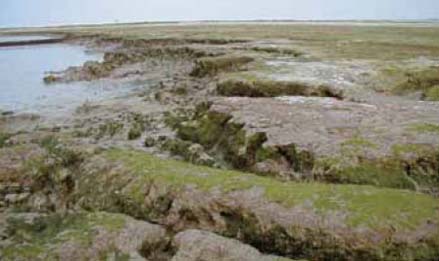
The values placed on the environment may give rise to contest, the second major theme of this course. This theme can help us understand why environmental questions are so pressing. Contests over values may result in conflicts between interests. Within the Blackwater estuary there are many different human interests each of which puts its own particular value on the environment: fishermen and farmers will value the environment as a source of livelihood; industrialists will value its capacity for absorbing pollutants or waste; developers will focus on the market value of the location; wildfowlers prize its potential for sport; birdwatchers or ramblers will value the environment for its own sake, as an end in itself. These differing values often result in conflict between economic and non-economic interests. For example, around the Blackwater estuary the economic value of land for farming has led to the building of sea defences, the draining of saltmarshes and erosion of the marshes on the seaward side (Figure 5). This creates conflict between those interested in economic development (farming) and those interested in conservation (of an important habitat). The estuary provides many other examples of contested values leading to conflicts between interests, for example: conflict over fishing rights; conflict over the public's right of access to the shore; and conflict over proposals for urban or industrial development. In deciding how they value the environment and then pursuing their interests, different groups will not only come into conflict with each other but may have profound effects on non-human species and habitats.
Each interest group will have access to various forms of political power, which they can use to promote their interests. For example, industrialists and developers have economic resources in the form of investment capital and employment; those with conservation interests are able to use the power of influence through the media or the support of local and national groups to exert pressure on decision makers. We shall develop these points later in this unit. For the moment we simply wish to note that studying environments can also be associated with the idea of contest and conflict.
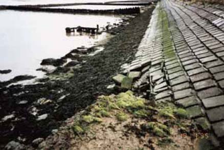
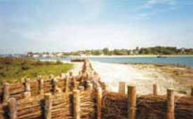
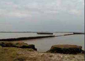
Returning to our viewpoint over the estuary, what other features are evident? Everywhere we can see signs of the effort to protect land from the incursion of the sea. Out to sea there is both dredging of channels and recharging of the foreshore with sand and gravel dredged from elsewhere (Figure 6). The aim is to create barriers to the erosive power of the waves on the shoreline. All around the estuary are earthen sea walls, often dating back to the Middle Ages, enabling grazing and later arable land to be reclaimed from the saltmarsh. In some places, especially close to human settlements, the walls have been reinforced (Figure 7). Elsewhere, in a few places walls have been deliberately breached to enable the recreation of saltmarsh (see Figure 20). Saltmarsh dissipates the energy of waves and thereby provides a form of natural defence against the sea. On a coast along which sea levels are rising and that, from time to time, experiences destructive winds and tides, protection by reinforcing walls is only afforded to urban settlements and valuable structures, such as Bradwell nuclear power station. Elsewhere, the effort to resist the sea is regarded as both too costly and, in the long run, futile. The sea level rise predicted as a result of climatic change merely reinforces the need to provide ‘softer’ forms of protection (such as saltmarsh rather than sea walls) in the hope that creation of new marshlands will compensate for those that are lost through erosion.
1.2 A balancing act: conservation and sustainable development
All around this coast are examples of efortsf to protect or enhance the environment. There are nature reserves, country parks and protected habitats, and the whole coastal fringe is designated as an area of scientific interest requiring special protection. There is also evidence of the need to manage the environment to ensure, so far as possible, compatibility between competing interests. Built development is prevented along the shoreline and restricted to existing settlements; caravan parks are carefully sited; and on the water the mooring and speed of boats are regulated. The environment of the estuary is the subject of regulation by agencies, planning by local authorities, and management by partnership and voluntary schemes. Its specific environmental qualities, such as its habitats and bird life, are defended by national and local environmental pressure groups and sometimes protected by legislation. From time to time, when a particular threat is perceived, local action groups may organize protests (such as those over plans for a nuclear waste site at Bradwell during the 1980s). The point we are making here is that environments evoke responses in the form of human action that is aimed at preventing, mitigating or managing change and conflict. In turn, environments respond to human action and this may lead to an alteration in human responses, and so on in a continuing mutual adaptation of human and natural processes.
Click here to view: Conservation in the Blackwater estuary, adapted from the Blackwater Estuary Management Plan.
This notion of responses is the third theme for this course. Response also suggests the idea of responsibility, not only for the present but for the future also. This is the kernel of the idea of sustainable development, endorsed at the United Nations Earth Summit at Rio in 1992 and which has since become a philosophical basis of much environmental policy making. In its most famous formulation sustainable development has been defined as development that 'meets the needs of the present without compromising the ability of future generations to meet their own needs’ (World Commission, 1987, p.43). This definition combines the requirement of sustainability of the environment with th need for development, thus satisfying both ‘the basic needs of all and extending to all the opportunity to satisfy their aspirations for a better life’ (World Commission, 1987, p.44). Here, there is a recognition that environmental change both now and in the future will have different impacts on people and places and non-humans and habitats, reflecting their relative vulnerability. For example, people in comparatively affluent areas are better able to defend themselves (at least for a while) against rises in sea level than people in poorer low-lying areas (such as parts of Bangladesh) whose very survival may be threatened.
Sustainable development has been adopted as a fundamental principle of environmental policy making at all levels. For example, the idea has been translated (in the Blackwater Estuary Management Plan) into the specific context of the Blackwater estuary in the following terms:
To promote the sustainable use of the estuary so that it can yield the greatest benefit to the present population whilst maintaining the potential for the estuary to meet the needs and aspirations of future generations, in a manner compatible with the maintenance of the natural properties of the estuary and its value for wildlife.
(Maldon D.C. and Colchester B.C., 1996, p.8)
The marshlands and the animal and plant life they support are especially vulnerable to changes in climate and sea level, making sustainable development hard to achieve. The aspiration of sustainable development in other contexts is difficult to translate into specific forms of action. We introduce it here to note the point that environmental responses combine both a reaction to contemporary problems and needs, and a conception of the kind of environment that should be bequeathed to the future.
Activity 1
Consider the human use of the environment and the idea of contest between uses and ways of valuing the environment.
The Blackwater estuary is a dynamic environment. It is managed and has changed over time.
Click on the link below to watch the following video clip that outlines the human use of the environment and presents the idea of the contest between uses and ways of valuing that environment.
Whose interests are the most important in managing this coastal environment: migrating birds, farmers or fishermen?
1.3 Managing environmental risks and uncertainties
The following activity and video clip presents the discussion of the Old Hall marshes in relation to managing environmental risks and uncertainties. It also introduces the key concepts of sustainable development in a period of environmentally uncertain climate change.
Activity 2
Click on the link below to watch the following video clip that outlines how environmental risks and uncertainties can be managed.
How can we manage an ever changing coastline?
How can we plan for long term environmental change and still meet immediate human needs?
2 Environmental responses
2.1 Managing risk in conditions of uncertainty
Earlier we considered what is meant by ‘environmental responses’. There are two aspects to this concept. One is the response made by the environment to processes of change, whether brought about by natural or human causes or a combination of both. The other is the response to environmental changes made by humans or non-humans. In this section we shall consider both of these aspects of response by focusing on an issue of particular significance in the Blackwater: how the environment of the estuary might be ‘managed’ in response to those changes that are having an impact on its biodiversity.
2.2 Change and response in the ‘meadows of the sea’
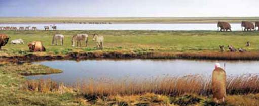
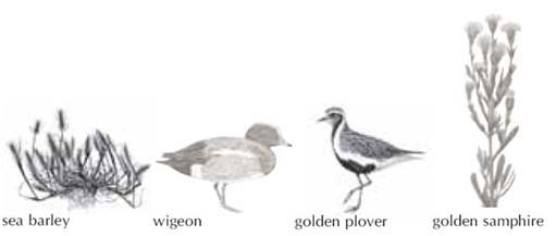
Midway along the northern shore of the Blackwater estuary lie the Old Hall Marshes on a peninsula three and a half miles long and lying between tidal creeks and mudflats (see Figures 3 and 15a). It is a wild, flat, remote area of mixed habitats of reedbed, open water, saltmarsh and improved and unimproved grassland. Ecologically, it constitutes coastal grazing marsh (Figure 15b) defined as ‘periodically inundated pasture or meadow with ditches which maintain the water level, containing standing brackish or fresh water’ (Essex Biodiversity Action Plan, 1999, p.145). These marshes, the so-called ‘meadows of the sea’, are vibrant with life. Old Hall Marshes contain 268 recorded plant species, among them the rare saltmarsh goosefoot (Chenopodium chenopodioides), sea barley (Hordeum marinum) and golden samphire (Inula crithmoides). There are over 24 mammals and about 1,000 species of invertebrates, and over 100 of them are rare. Fish and shellfish, including oysters, thrive in the creeks surrounding the marshes. Above all, these marshes provide breeding and feeding grounds for 240 species of birds, especially wildfowl (50 per cent of the total numbers in the Blackwater) like wigeon and teal, and waders (32 per cent) such as redshank, golden plover, dunlin and lapwing.
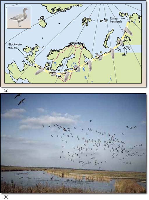
Old Hall Marshes are a crossroads, a fulcrum of bird migrations that link the local ecosystems to habitats thousands of miles away. Some species use the marshes as a stopover on the long journey south along the Eastern Atlantic Flyway to Africa, while others spend the winter here. Particularly prominent are the dark-bellied brent geese that breed in the Taimyr Peninsula in the Arctic tundra of Siberia before wintering on the marshlands of the southern North Sea basin. Old Hall Marshes support a peak of approximately 4,500 of these birds in winter, about two per cent of the total world population. In order to conserve the value of these marshes for habitats and wildlife they have been designated as a National Nature Reserve and with the rest of the estuary are protected in a variety of other ways.
Click here to view: Protected environments: Old Hall Marshes provide rich habitats and feeding grounds for wildlife (map supplied by RSPB).
Conservation has become an important element in responses to natural and social changes in these marshlands. Old Hall Marshes are relatively recent, converted from saltmarsh to grazing marsh in a succession of reclamations that started in the sixteenth century and that are marked by counter-walls across the area. The purpose of reclamation was commercial, providing land for pasture for both sheep and cattle. Though remote, the marshes were just a two-tide journey by sea on a sailing barge to and from the London markets, so encouraging a profitable trade in animals reared or fattened on the marshes for meat or wool.
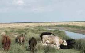
The marshlands had other human uses, too: there are still traces of the decoy ponds used to ensnare wildfowl for fresh meat, and from the nineteenth century the marshlands attracted wildfowlers shooting birds for sport. Indeed the fact that this land supported large numbers of birds was a key reason for the survival of Old Hall Marshes while grazing marshes elsewhere were being ploughed up in the drive for food production during and after the Second World War. Since 1984, Old Hall Marshes have belonged to the Royal Society for the Protection of Birds, thus ensuring the conservation of the site as grazing land (cattle in summer, sheep in winter), grazing being essential for maintaining certain habitats and species.
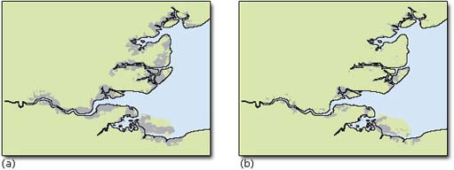
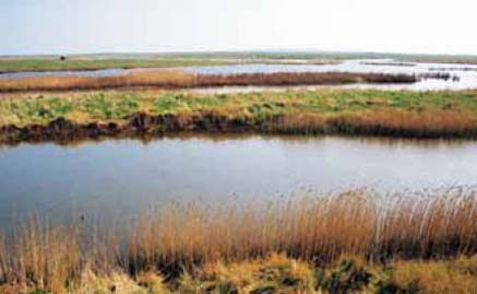
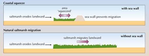
Under the EU's Habitats Directive, coastal management must be sustainable; that is, there should be no net loss in terms of area of intertidal habitats. This poses a considerable challenge since in recent years both grazing marshes and saltmarshes along the Essex coast have declined considerably. Over two-thirds of grazing marsh was lost during the twentieth century, the biggest losses through conversion to arable land (Figure 14). But on the seaward side the protection of grazing marsh has contributed to the loss of saltmarsh. Since medieval times, enwalling has converted about 40,000 hectares of the Essex saltmarsh for agriculture leaving only 4,400 hectares, which is 10 per cent of the UK's total. This area has been eroding at the rate of two per cent per year (over one fifth of the total was lost during the last quarter of the twentieth century). The saltmarsh's gradual migration inland, as the sea level rises, is blocked by the sea wall, and the marsh is caught in a ‘coastal squeeze’ between the walls and the rising water. As Figure 15 shows, the gradual erosion causes a loss of important habitat as well as a reduction in an important form of coastal protection. With the onset of human-induced climate change the very survival of the coastal marshlands is at stake.
2.3 Climate change: survival at stake
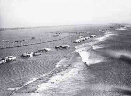
Despite efforts to define it, the boundary between land and sea is constantly changing. In the long run the combination of rising sea level, sinking land and possible major storms, such as the one that devastated the Essex coast in 1953 (Figure 16), indicates a battle that the sea must ultimately win.
The invisible threat of global warming is widely regarded as inevitable, provoked by the increased release of greenhouse gases, and likely to result in climatic extremes and significant rises in sea level within one or two generations. Predictions by the Intergovernmental Panel on Climate Change (IPCC, 2001) indicate that, by the end of this century, global sea level could have risen by as much as 0.88 metre as a result of global warming.
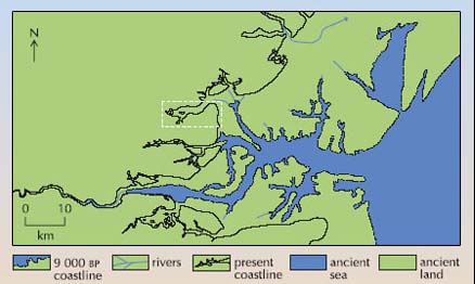
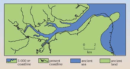
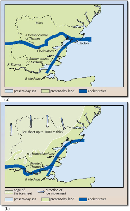
In addition to a global sea level rise, the Blackwater estuary is also affected by a local change in sea level. During the last glacial Stage, a thick layer of ice covered the whole of central and northern Britain. When this ice melted, and the weight on the land was reduced, the land in northern Britain began to rise (a process called ‘glacial rebound’), tilting Britain and causing part of the south, including the Blackwater estuary, to sink. This caused a relative rise in sea level in this area, which is still continuing today, at a rate of about 0.15 metre a century. So for the Blackwater estuary, the rise in sea level is caused both by global warming and local glacial rebound.
There is much uncertainty about the scale, timing and impact of climate change. However, appreciation of the likelihood of significant changes in the foreseeable future has prompted recognition that response in some form is necessary if the possible consequences to human and other forms of life are to be avoided. We focus here on some of the uncertainties and possible effects of climate change, and on what the nature of the response might be.
Click here to view, 'Land lying below the five metre mark at the Blackwater estuary, adapted from the Blackwater Estuary Management Plan'.
For any estuary, such as the Blackwater, where much of the surrounding land area lies within a few metres of the sea (see the five metre contour around the Blackwater coast in Figure 20), any consistent rise in sea level could lead not only to destruction of the saltmarshes and widespread flooding, but inundation of agricultural and urban areas beyond. However, on a geological timescale, we have seen that sea level change of over 100 metres has occurred in the past. Part of the present-day concern is the rate of change, which is much faster now than at any time since the rapid warming and associated sea level rise at the end of the last glacial Stage at 11,500 BP.
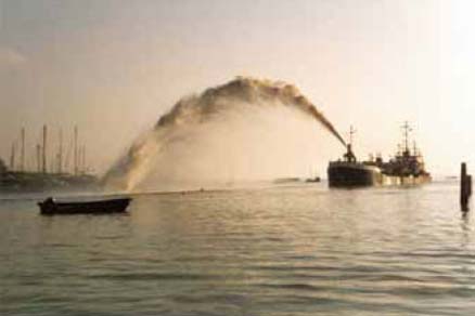
In the Blackwater estuary, human response is in the form of various methods of coastal management. Defensive ‘hard’ sea walls are expensive, inflexible and difficult to maintain and are now used only to protect areas of urban development (Figure 7). Elsewhere ‘soft’ forms of coastal protection are used. For example, using brushwood polders to provide shelter from waves, using sunken Thames lighters as wavebreaks, or recharging the foreshore using dredged materials to break the force of the waves offshore (Figures 17, 18.
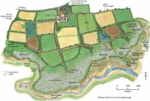
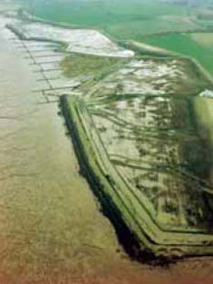
In several parts of the estuary new saltmarsh is being created in various schemes described as ‘managed retreat’ or ‘coastal realignment’. One such scheme, managed by the Essex Wildlife Trust, is at Abbotts Hall Farm, an area of arable farmland adjacent to Old Hall Marshes (Figure 19). The idea is to breach the three kilometre wall at five points, allowing ingress and dispersal of the sea, gradually transforming the low-lying meadows back into saltmarsh. On the rest of the farm, hedgerows, grassland margins, ponds and woodland are being created to encourage greater biodiversity. Under government-sponsored arable reversion schemes, financial incentives are offered to farmers willing to manage their land to enhance its value for conservation. Although coastal realignment has been successful in some places, such as Orplands (Figure 20), its impacts elsewhere may be unpredictable and uncertain.
The present Blackwater coast has been created by a combination of natural and human responses to change. For several centuries sea walls have defined the border between reclaimed land and sea, while gradually, on the seaward side of the walls, the incremental loss of most of the saltmarsh has removed the first line of defence. Recently, the value of the saltmarsh biodiversity and the protection it affords has led to efforts to prevent further losses. At present, erosion far exceeds the creation of saltmarsh. Ultimately, if local sea level rise continues at its present rate of six millimetres per year, nothing can prevent the inundation of the Essex marshlands and areas well inland. Climate change will produce a range of problems affectingall areas, causing loss of species or livelihoods. Drought-prone areas are likely to become larger and might occur just as they did in the past in the area that is now marshlands. Climate change could also lead to more extreme events, such as more frequent and heavier storms, and high sea levels (storm surges) which add to the flooding caused by sea level rise.
Although we can adapt to the effects of climate change by retreating (e.g. from coastal areas), by accommodating them (e.g. growing flood-tolerant crops) and by protecting against them (e.g. building sea walls), we cannot prevent such effects. On a global scale, roughly one billion people live at or just above sea level, and cities such as London, New York, Tokyo, Bangkok and Shanghai could be submerged. Poorer countries are particularly vulnerable and have limited affordable options. Some, like the low-lying Pacific island of Tuvalu, face extinction and, in 2002, some of its population have already moved to New Zealand.
We can only slow the process of climate change by reducing greenhouse gas emissions, notably carbon dioxide emitted into the atmosphere from various sources such as fossil fuel power stations. However, before undertaking any drastic or expensive actions, governments need to know how good the predictions of the effects of global warming will be – how accurate are they? To examine this we need to look at predictions in more detail. The Intergovernmental Panel on Climate Change (IPCC) report of January 2001 gave an estimate for a maximum global sea level rise of 0.88 metre by the end of the century. However, the minimum estimated change is only 0.09 metre. These predictions are made by making various assumptions, such as rates of greenhouse gas emissions and their re-absorption by, for example, vegetation (Blackmore and Barratt, 2003). You may wonder what is the use of a prediction that gives such a large range, 0.09–0.88 metre. This is a real problem, and such a range is an indication of the uncertainty of the result.
However, as uncertain as results like these are, they have to be used as a basis for policy decisions on global warming. If we waited until the end of the century to see whether sea level will rise by 0.09 metre or by 0.88 metre and then decided what to do about it, it would obviously be too late to stop it happening. It could be argued that it would be better to plan for sea level rise now. This is the basis of the precautionary principle set out in the World Charter for Nature adopted by the UN General Assembly in 1982 – ‘lack of scientific certainty should not be used as a reason for postponing measures to prevent suspected or threatened environmental damage’. The principle has subsequently been incorporated into various international conventions on the protection of the environment. The strength of the precautionary principle is that it may provide a basis for action when science is unable to give a clear answer. In the Blackwater estuary the rise in sea level is already sufficiently palpable for precautionary action to be taken.
Human responses to environmental change may be conceived in terms of reducing risk. We define risk as the probability of a hazard occurring at some future point in time or as a result of a particular action. An example of the former might be the risk of a coastal habitat being destroyed within a hundred years. The risk of saltmarsh loss through building a sea wall is an example of risk resulting from a particular action. Thus risk implies a probability of change, and therefore requires prediction of the likely outcomes of response. The confidence that can be placed in any prediction depends on the level of uncertainty about the processes responsible for change. As we have seen, there is considerable uncertainty about the future change of sea level. But in terms of our key question the issue is so pressing that we cannot afford to wait and see. In these circumstances a precautionary response in the hope that the impact may be mitigated is the best we may do.
Activity 3
Throughout this section we have discussed how the Blackwater environment has been ‘managed’ in response to changes in sea level. Try now to identify some of the human responses to change in the Blackwater, including those both beneficial and detrimental to the conservation of the estuary's biodiversity.
Discussion
Comment
Responding to the incursion of the sea into residential and agricultural areas, humans have built solid sea walls and left undefended the saltmarsh on the seaward side of the walls. This has resulted in the progressive erosion of the saltmarshes, thereby threatening the species that depend on these areas for their livelihood. People have also created ‘softer’ forms of coastal defence, such as brushwood polders for breaking waves.
Coastal realignment, however, is a response that works with (rather than defends against) the constantly increasing sea levels. In breaching sea walls and allowing saltmarsh to migrate inland as the sea level rises, humans are working for the greater long-term benefit of Blackwater biodiversity. Humans have also introduced various types of designation to ensure the marshlands biodiversity is both conserved and enhanced.
Click below to view the final video clip in this course. The following clip addresses many of the questions that have been set in the activities of this course. It recognises the need to manage disparate interests and raises the key concept of sustainability as a means of evaluating the competing interests and planning for the future.
Conclusion
In this course we have used the Blackwater to identify the theme of environmental response. Responses involve the interaction of human and natural processes. For example, the rise in sea level experienced in the estuary is partly natural readjustment after the Ice Age and partly a response to greenhouse gas emissions caused by human activity. This rise has brought about two forms of response: human responses to change in the environment and responses made by the environment.
The first form, responses by humans to the impacts of environmental change, includes the building of sea walls to prevent the loss of productive land, and various measures of coastal protection and conservation management to prevent further loss of saltmarsh and its biodiversity.
The second form of response, that made by the environment to changes, includes: coastal erosion as a response to sea level rise; extinction of species through loss of habitat; and loss of saltmarsh through coastal squeeze.
You may note that responses tend to have both negative and positive impacts. Thus, responses by and to the environment have resulted both in the loss of saltmarsh by flooding and embankment, and in its re-creation through managed retreat (Figure 20).
References
Acknowledgements
Except for third party materials and otherwise stated (see terms and conditions), this content is made available under a Creative Commons Attribution-NonCommercial-ShareAlike 4.0 Licence
Course image: Michael D Beckwith in Flickr made available under Creative Commons Attribution 2.0 Licence.
The material below appears in: Understanding Environmental Issues (2003) (eds) Steve Hinchliffe, Andrew Blowers and Joanna Freeland published by The Open University in association with Wiley and forms part of the course materials for: U216 Environment: change, contest and response.
Grateful acknowledgement is made to the following sources for permission to reproduce material:
Figures 1, 2, 4: © Darren Wycherley; Pdf 1 (page 2), Pdf 3 (page 3), and Pdf 5 (page 5): Crown © reproduced with the permission of Ordnance Survey on behalf of Her Majesty’s Stationery Office, Licence No ED 100020607; Figures 5, 17, 18, 20: © The Environment Agency Eastern Area; Figures 6, 7: © The Environment Agency; Pdf 2 (page 2): courtesy of the Essex Record Office; 8, 9: Hunter, J. (1999) The Essex Landscape: A Study of its Form and History, Essex Record Office; Figure 10: Lucy, G. (1999) Essex Rock: A Look Beneath the Essex Landscape, Essex Rock and Mineral Society; Pdf 4 (page 5) RSPB East Anglian Regional Office; Figures 12b, 13b: © Bob Glover; Figure 14a & 14b: RSPB; Figure 15: East Anglian Salt Marshes, Environment Agency; Figure 16: (c) Popperfoto; Figure 19: Essex Wildlife Trust;
Don't miss out:
If reading this text has inspired you to learn more, you may be interested in joining the millions of people who discover our free learning resources and qualifications by visiting The Open University - www.open.edu/ openlearn/ free-courses