2.1 The view from space
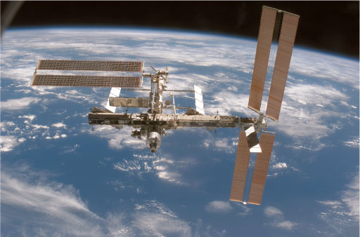
Since the early days of space exploration, 'top-down' weather information has been gathered in increasingly sophisticated ways. Figure 4 gives an impression of the kind of view that can be had on arrival at or departure from the International Space Station (ISS) some 320 km above the Earth. The ISS is just one of a vast number of artificial satellites that have been placed in orbit around the Earth. Box 1 gives some information about the orbits of Earth satellites.
Box 1 Satellite orbits
An object that is in orbit about the Earth (or any other planet) is usually referred to as a satellite. Because a satellite is so far above the atmosphere, there is nothing to impede its motion so it is not necessary to keep the engines running. The duration of a single orbit is called the 'orbital period'. The further away a satellite is from the surface of the planet, the longer it takes to make one complete orbit. Figure 5 shows the orbital periods, measured in days, for orbits at various distances from the centre of the Earth. The horizontal axis is marked in units of the radius of the satellite's orbit divided by the radius of the Earth (which is about 6400 km). A value of 1.0 on this scale indicates ground level. Values smaller than 1.0 do not represent a real situation, since the satellite would be underground!
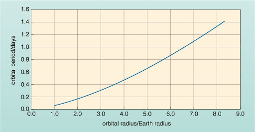
How high above the surface of the Earth is a satellite for which the value of orbital radius/Earth radius = 3.0?
The satellite is placed at 3.0 Earth radii from the centre of the Earth, i.e. 2.0 Earth radii, or about 12 800 km, above the Earth's surface.
What is the orbital period in days of a satellite placed at 3.0 Earth radii from the centre of the Earth?
This satellite would have an orbital period of about 0.3 days.
What is this orbital period (0.3 days) in hours?
0.3 days = (0.3 × 24) hours = 7.2 hours = 7 hours 12 minutes
Detailed information about weather systems can be recorded by satellites and transmitted back to ground stations whenever a convenient receiver can 'see' the satellite. A particularly attractive option is to set a satellite into what is called a polar orbit. The satellite passes over the North and South Poles at a height of 700-800 km (about 0.12 times the radius of the Earth) above the surface. You can see from Figure 5 that the orbital period of such a satellite is more than 0.05 days and less than 0.1 days. In fact it is 0.07 days (or 100 minutes). From this height, cameras can easily see features as small as 1 km across. At the Equator, with a field of view about 2800 km wide, the tracks below successive orbits just overlap. This is because the Earth rotates below the satellite, so that every time the satellite crosses the Equator in one direction it is over a point 2800 km further west than it was at the previous crossing.
The circumference of the Earth at the Equator is about 40 000 km. How many orbits will be required to cover the globe completely?
The number of orbits required is
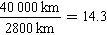
How many hours will it take for the satellite to go through this number of orbits?
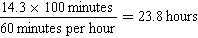
Since each complete orbit takes 100 minutes, the time taken to cover 14.3 orbits will be 14.3 × 100 minutes.
This corresponds to
Thus a satellite in polar orbit can photograph the whole globe in one day.
The USA's National Oceanic and Atmospheric Administration (NOAA) operates a pair of polar orbiting satellites like this and even has three 'old series spares' dating from before the turn of the century. The European polar orbiter called 'MetOp' went into service in May 2007 and has a similar weather reconnaissance role.
A more immediate picture of global weather can be had from satellites that sit out among the telecommunication platforms. These are in what is termed a 'geostationary' orbit at 6.7 Earth radii from the centre of the Earth.
According to Figure 5, what is the orbital period if a satellite is placed at 6.7 Earth radii from the centre of the Earth? As seen from a satellite in this orbit over the Equator, how would the Earth appear to move underneath the satellite?
The orbit lasts one day. Provided the satellite lies exactly over the Equator, the disc of the Earth will appear fixed.
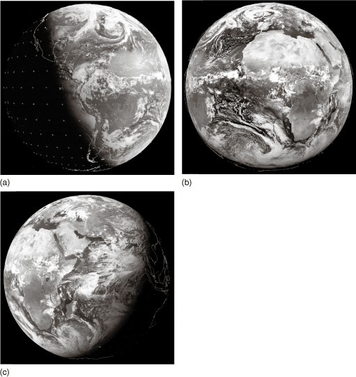
A satellite that is geostationary sits over the Equator and over a single fixed longitude. Looking back at the Earth from a geostationary platform, the disc of the Earth appears very much as a standard football would to you from a distance of 75 cm. You do not need a powerful telescope to get a good view at this range - all you need is a good camera. Figure 6 shows the view from three geostationary meteorological monitoring satellites; images like this are sent back to Earth every hour. Note that most satellite images from meteorological satellites are presented as 'grey-scale', i.e. like black and white photographs. Take some time to study the images and the caption of Figure 6 carefully.