

4.4 Closure of an ocean
Some of the oldest rocks in the British Isles are over 2500 million years old, whereas elsewhere on the Earth rocks as old as 3800 million years have been found within the continents. These ages contrast with that of the world's oldest in situ oceanic crust (excluding obducted ophiolites), which is only 200 million years. Considering that basins must have been opening and closing for approximately the same amount of time as continental crust has been forming, this implies that after an ocean basin has grown for a period of ~200 million years, the adjacent passive continental margin becomes a destructive margin and starts subducting the oceanic lithosphere (see Figure 6d).
SAQ 2
Why does this change occur?
Answer
When the oceanic lithosphere first forms, it is relatively hot and buoyant. As it moves away from the spreading centre and underlying heat source, it cools down and becomes less buoyant.
By the time the oceanic lithosphere is ~200 million years old, it is so cold and dense compared with the adjacent continental lithosphere, that it starts to sink into the underlying asthenosphere under its own weight (helped by the continual push of newly formed oceanic lithosphere). This initiates subduction. If the rates of subduction and sea-floor spreading are equal, this system will remain stable. If, however, subduction is occurring at a faster rate than spreading, convergence will occur and may result in collision of the two plates, eventually forming an orogenic belt.
Recent research on how long it takes for a passive margin to switch to an active, destructive margin suggests that this can be as little as ~10 million years. Therefore, a complete cycle of ocean-basin formation, opening and closure should take approximately 400–500 million years (i.e. ~200 million years to open + ~10 million years for the switch from a passive continental to destructive margin + ~200 million years to close).
SAQ 3
What evidence do you think geologists can use to identify the presence of past oceans and their margins?
Answer
They can look for specific igneous, sedimentary and metamorphic assemblages that are characteristic of subduction zones, continental slopes and deep ocean basins.
In addition, specific structural features that are characteristic of a subduction zone can be looked for.
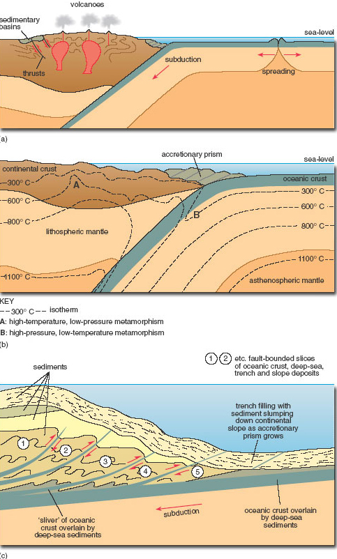
(a) Schematic cross-section through a subduction zone involving continental crust, illustrating the key features described in the text.
(b) Detailed sketch showing the arrangement of a paired metamorphic belt, which runs parallel to the subducting plate boundary. High-temperature, low-pressure metamorphism (A) occurs in the overlying continental plate, where the elevated geothermal gradients result in a rapid increase in metamorphic facies from greenschist to amphibolite and maybe granulite facies with increasing depth. The low-temperature, high-pressure metamorphism (B) in the subducting oceanic plate is characterised by blueschist facies, indicative of low geothermal gradients.
(c) Detailed sketch of the principal features of an accretionary prism developed in the trench above a subduction zone. A series of thrust-bounded slices of oceanic crust and sediment develops on the margin of the opposing plate, as the downgoing plate carries material beneath the sedimentary-tectonic pile. As the newest slice
 is inserted, it alters the orientation of earlier slices
  , so that older fault planes become steeper. Sedimentation is contemporaneous with thrusting, with slumps and turbidity flows triggered by tectonic steepening of the trench slope.
Specific examples of evidence for a destructive plate margin are:
Igneous rocks: At subduction zones, tholeiitic and calc-alkaline basalts are formed by the release of fluids from the subducting slab into the overlying mantle wedge, which undergoes partial melting (Figure 5b and Figure 7a). These basaltic melts rise up into the crust, where they can be temporarily stored in a magma chamber and undergo fractional crystallisation eventually to form andesites and rhyolites (extrusive) or their intrusive equivalents, diorites and granites. In general, island arcs are dominated by mafic–intermediate extrusive rocks, whereas active continental margins are dominated by intermediate–felsic plutons. In addition, magmas that are rich in CaO and alkali elements (Na2O, K2O) and have a low FeO/MgO ratio (known as ‘calc-alkaline magmas’) are indicative of a subduction zone environment, and are typically more abundant at mature (i.e. older, more established) island arcs and active continental margins than immature island arcs.
The terms ‘tholeiitic’ and ‘calc-alkaline’ can be used to classify different types of igneous rocks according to their geochemistry and/or subtle changes in groundmass mineralogy. Even though these different categories of rocks cannot be distinguished from each other in hand-specimen, once recognised (by detailed petrological and geochemical studies), they can help petrologists to identify the environment of formation. For example, although tholeiitic rocks form in most igneous environments, calc-alkaline rocks are generally restricted to mature arc systems. Alkaline rocks meanwhile represent melts that have formed at deep levels in the upper mantle, and are common at the back of mature island arcs or in continental rifting zones.
Metamorphic rocks: The key metamorphic indicator of a past subduction zone is a paired metamorphic belt (Figure 7b). In this belt, the subducting oceanic plate is subjected to low-temperature, high-pressure (i.e. blueschist) metamorphism, while the overriding plate is characterised by high-temperature, low-pressure greenschist to amphibolite (or even granulite) facies metamorphism, associated with the intrusion of magma and thickening of the continental crust.
Sedimentary rocks: The continental shelves bordering subduction zones are relatively narrow, with sedimentary material transported rapidly from the source area into the oceanic trench, by a series of high-energy density currents called turbidity currents. A turbidity current consists of a dense mixture of sediment and water that flows downslope beneath the overlying, less dense, clear water. The end result is a succession of fining-up units formed each time the sediment is deposited, initially from the bed load and then out of suspension. Each unit is referred to as a turbidite. Turbidites can contain grains from nearby volcanic terrains as well as deep-sea sediments. Turbidite sequences deposited on the downgoing plate are not generally subducted, but accumulate as an accretionary prism above the subduction zone (Figure 7a–c). (Students attending the residential school will see a nice example of a turbidite sequence at Tebay, which is situated on the edge of the Lake District.)
Structure: Accretionary prisms form in the oceanic trench directly above the shallowest part of the subduction zone (Figure 7b–c). In many cases, slices of trench-fill sediments and oceanic crust become detached from the subducting slab and stick to the overriding plate. As subduction continues, these slices of detached sediments and oceanic crust begin to stack up and form a series of thrusts, as a result of tectonic accretion. While more slices are tectonically accreted, early-formed thrusts are progressively rotated so that they dip more steeply. With continued sedimentation into the trench, the accretionary prism can become covered by younger turbidite successions, which themselves may be included in later tectonic accretion and thrusting as subduction continues. The end result of this is that within each thrusted slice, the sedimentary successions get younger upwards and in the direction away from the downgoing plate, and pass upwards from deep-water sediments (e.g. chert, black shales) to trench, trench slope and shelf deposits (Figure 7c). However, the ages of successive thrusted slices decrease towards the trench and downwards in the prism, with faulting changing from low angle near the trench front to high angle towards the overriding plate (Figure 7c).