
5.2 Precambrian and Lower Palaeozoic Basement
The Precambrian and Lower Palaeozoic Basement of the British Isles is a series of nine discrete, exotic terranes whose boundaries are fault systems that have undergone large but usually unknown amounts of lateral and vertical movement over time (Figure 11 and Table 2). Each terrane is a specific geographical area characterised by a distinctive geological history, which was different from that of its current neighbour up until the time that they ‘docked’ together. Once united, the originally separate terranes then underwent the same geological processes.
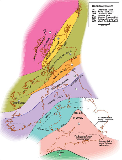
Click to view larger version of a simplified map of the British Isles [Tip: hold Ctrl and click a link to open it in a new tab. (Hide tip)]
| Terrane | Main rock units |
| (1) Hebridean Terrane | Archean and Lower Proterozoic gneiss overlain by undeformed sediments from the Upper Proterozoic (terrigenous red sandstones) and Cambrian to Middle Ordovician (shallow-water marine siliciclastics and limestones). |
| (2) Northern Highlands Terrane | Precambrian to Upper Ordovician and Silurian metamorphosed sediments and mafic to felsic igneous rocks. |
| (3) Central Highlands (Grampian) Terrane | Upper Proterozoic metasediments overlying gneiss. Based on metamorphic evidence, this terrane is known to have accreted to the previous two by the Early Silurian. |
| (4) Midland Valley Terrane | A series of small, discrete terranes faulted into one main region, or superterrane. The main basement is thought to be an ancient fore-arc region, covered by Upper Palaeozoic volcanics (tholeiitic and calc-alkaline), volcaniclastic sediments, mudstones, sandstones and carbonates. |
| (5) Southern Uplands Terrane | Lower–Middle Palaeozoic sediments including turbidites, mudstones, pillow lavas, chert and some ophiolite material, indicative of an open, spreading oceanic environment. |
| (6) Leinster–Lakes Terrane | Lower Palaeozoic marine siliciclastic sediments, mudstones and limestones, along with subduction-related calc-alkaline volcanics. |
| (7) Monian Terrane | Precambrian calc-alkaline volcanics, blueschists, sediments and mélange, representative of a Precambrian to Early Cambrian subduction zone. |
| (8) Avalon–Midland Platform Terrane | Cambrian–Ordovician sedimentary succession of shallow-water marine siliciclastics and limestones on a Precambrian basement, grading to terrigenous red beds and some mafic volcanics. |
| (9) Lizard Terrane | Middle–Upper Devonian ophiolite complex associated with metamorphosed igneous and sedimentary successions, overlying Ordovician quartzites. |
Using the rock units present in each area, it is possible to establish the type of environment(s) each terrane originally represented. However, as each terrane is delimited by fault boundaries, it is not always apparent exactly where the terranes originally formed in relation to each other. Despite this we can be sure that the nine terranes that make up the British Isles joined together into their present configuration between Proterozoic (Late Precambrian) and Carboniferous (Late Palaeozoic) times.
Question 4
Using the Ten Mile Map (N) in conjunction with Figure 11, find the thick black line that represents the Moine Thrust. Everything to the west (left) of this line (including the Outer Hebrides and part of the Inner Hebrides) is the Hebridean Terrane.
(a) What is the oldest rock unit in this terrane?
(b) Apart from this, what other rock unit is dominant in this terrane?
Answer
(a) Much of the Hebridean Terrane is made up from undifferentiated gneiss from the Lewisian complex, which is the oldest rock unit in the British Isles.
(b) From Rhum (NM(17)3090), up to Enard Bay (NC(29)0513), Torridonian Sandstone is predominant, dating from the Proterozoic (i.e. Late Precambrian and not the Palaeozoic, as indicated on the Ten Mile Map).
Question 5
Trending across the northern Hebridean Terrane is a series of multiple thin units (numbered 5 and 6) oriented in a north-westerly direction. What name can be used to describe them?
Answer
Units 5 and 6 consist of intermediate to mafic dykes, and form part of the Lewisian Complex. In this abundance, they can be referred to as a dyke swarm. Note that they do not cut across the Torridonian Sandstone, which indicates that the dykes were intruded before the sandstones were deposited.
Question 6
How does the dyke swarm in the north of the Hebridean Terrane compare with that on Skye?
Answer
One of the most obvious differences between the two dyke swarms is that on Skye, the dykes are trending in a NNW–SSE direction, rather than NW–SE. Closer inspection also reveals that they are made up of unit 35, and not units 5–6.
In fact, the dykes on Skye are much younger than those to the north, and were intruded as the North Atlantic Ocean began to rift open during the Early Tertiary. These dykes can be followed all the way across southern Scotland into northern England, and students attending the residential school will examine one of the more extensive dykes from this event – the Cleveland Dyke.
Question 7
Using the stratigraphic key on the Ten Mile Map (S) as a guide, what are the oldest rocks in the southern British Isles?
Answer
According to the key, the oldest rocks in the southern half of the British Isles consist of Precambrian hornblende schists (29) and gneiss and mica schists (30).
Careful examination of the map reveals that these rocks occur in Anglesey, north-west Wales (SH(23)48). The units labelled 29 and 30 near the Lizard (SW(10)71) and Start Point (SX(20)83) are now known not to be Precambrian; they are in fact associated with the Variscan Orogeny. There are, however, Precambrian rocks in England that are not distinguished on the key, because they are intrusive, with the oldest of these occurring near Leicester (SK(43)51). In Ireland, the oldest rocks occur in the south-eastern corner around Rosslare, County Wexford, and are part of the same basement terrane as those in Anglesey (the Monian Terrane, Figure 11 and Table 2).
As the unit numbering system in the North and South Ten Mile Maps is the same, it should be apparent that the oldest rocks in the southern British Isles are considerably younger (units 29–33) than those in the northern British Isles. Table 2 summarises the main units found in each of the basement terranes across the British Isles. Although for many purposes the geological history of the British Isles can be described using the simpler five-fold lithotectonic system, it is often helpful to consider these nine discrete exotic terranes, particularly in relation to the structural evolution of the region.