
2.3.1 The general view
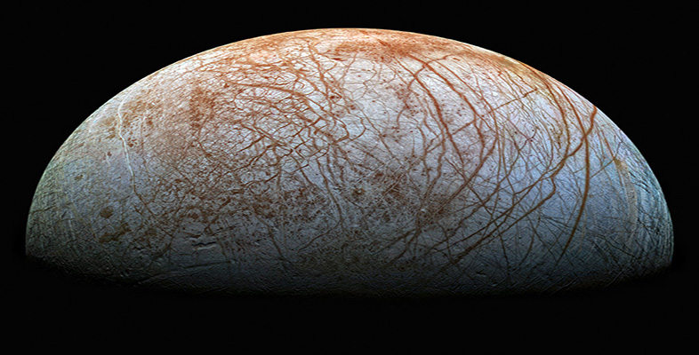
Figure 16 shows a Voyager 2 image of a large region of Europa. Examine this image carefully, in order to answer Question 4.
Click here for a larger version of Figure 16.
Box 5: Latitudes and longitudes on satellites
As soon as the first features were discovered on the surfaces of the satellites of the outer planets, it became necessary to define co-ordinate systems to map their locations. Latitude is simple to define; it is measured in degrees north and south of the equator, which lies halfway between the satellite's poles of rotation. By convention (established by the International Astronomical Union), for a synchronously rotating satellite 0° longitude is defined to run through the centre of the planet-facing hemisphere. Longitude is normally quoted in degrees measured westwards from here, and west is always to the left when you look at a body with north towards the top.
Question 7
(a) Study Figure 16 and write a short description of the kinds of features you can see on Europa's surface, noting for example relative brightness and characteristic shapes or textures. Concentrate on a simple description of appearance; we do not expect you to explain the origin or precise nature of what you can see.
(b) Try to deduce the relative ages of the features you have described.
Answer
Answering this question was part of your learning process. Do not worry if you found yourself at a loss. However, we hope that after reading the answer you will be able to tackle a similar task better in the future.
(a) Most of the surface area appears fairly featureless and mid-grey. This is cut by a large number of linear features (bands), up to several tens of kilometres in width. Most of the bands are dark. Some consist of joined segments of straight lines and some are curved. There is one prominent curved bright band near the lower left. The surface pattern is different in the upper right (northeast), where the pattern of bands disappears and the surface takes on a mottled appearance. Topography becomes apparent only near the right hand (eastern) edge of the view, where the Sun was low in the sky. It is difficult to trace the dark bands into this region, but instead a series of curved ridges shows up.
(b) The dark bands must be younger than the pale (mid-grey) surfaces that they cut. The mottled terrain in the upper right is probably younger than most of the bands, because these disappear when they reach the mottled terrain. Some of the curved ridges in the lower right-hand corner appear to run over the bands, and so these curved ridges must also be younger.
In answering Question 4, you should have formed an impression of an original surface that (at the scale of the image) appears relatively featureless, but was subsequently cut across by processes that produced dark bands. Later, the band-disrupted terrain was itself overprinted in places to produce mottled terrain and curved ridges. The dark bands cutting across much of Europa give it the appearance of a thoroughly cracked eggshell, but please be aware that there is no evidence in Figure 16 (nor on any more detailed images) that these 'cracks' are open fissures in the surface. In fact, there is very little topographic relief on Europa. The curved ridges in the lower right corner of Figure 16 are only about 200 m high.