
2.1.1 Bathymetry techniques
The development and use of a technique called sonar (SOund Navigation And Ranging) revolutionised the investigation of the oceans' depths. Originally developed for hunting submarines, in sonar a ship sends out a pulse of sound (a 'ping'), which is reflected by the target and the reflected sound wave is detected. It was soon realised that if they were 'loud' enough the underwater pings could detect the sea floor. If you measure the time it takes for a reflected ping to be heard and know the speed of sound in water, then you can derive the water depth. Using sonar, ships could record continuous depth measurements without stopping.
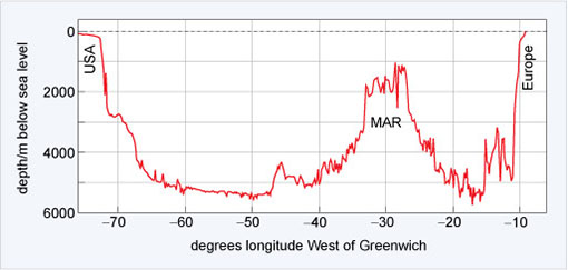
Figure 3 shows the bathymetry (i.e. depth measurement) across the North Atlantic Ocean along a latitude close to 39° N. At the point −30° W is the Mid-Atlantic Ridge (MAR).The variability in depth is astonishing.
A further technological development in the late 20th century has enabled scientists to derive bathymetry using data from satellites orbiting the Earth at unprecedented resolution. But because of the way the satellites orbit the Earth the resolution of the data decreases towards the North and South Poles.
-
What will happen to the amount of detail that can be seen if the resolution of the data decreases?
-
It will also decrease.
Imagine what a height contour map of a mountain range would look like if you had only one average height in each 10 km square - many hills and valleys would simply disappear.