
Mars Express
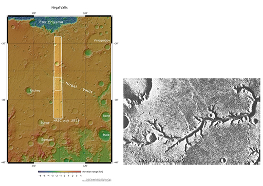
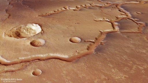
The Mars Express orbiter carries the High Resolution Stereo Camera (HRSC) that can take full colour images of the planet’s surface at a resolution of 2 m per pixel, or at 10 m per pixel in 3D. Remember Nirgal Vallis from the Mariner images? Figure 28 shows a HRSC image of that region in much higher resolution, and Figure 29 shows what can be achieved when images are combined with a digital elevation map. You can see in stunning detail the channels and perhaps even beds that may have been formed in the presence of water.
Mars Express also carries the OMEGA (Observatoire pour la Minéralogie, l’Eau, les Glaces et l’Activité) instrument, which can detect minerals on the martian surface. Clay minerals and hydrated sulfates, which can only form in the presence of water, were found at Terra Meridiani, Mawrth Vallis, Nili Fossae, Aram Chaos, and Valles Marineris - as well as in isolated locations in the martian Highlands.
Combining relative age information obtained from craters with the locations of these minerals showed that most of the clay minerals are found on the oldest, Noachian, areas, the sulfates on Hesperian areas and the iron oxides on Amazonian surfaces. (You met these martian geological periods in Activity 4).
This observation tells an important story: Mars’ climate changed from a wet, and likely warm, planet in the Noachian, to dryer and colder period in the early Hesperian. Then the cold and dry conditions that prevail today emerged in the Amazonian. The transition from warm and wet to cold and dry is now believed to have occurred around 4.2 billion years ago and is a critical part of the story of water on the red planet, and its possibility of ever having hosted life.
But Mars Express has given us one other, crucial, piece of information. Using its radar system (MARSIS - Mars Advanced Radar for Subsurface and Ionospheric Sounding), it may have detected a 20 km diameter subglacial lake, approximately 1.5 km beneath the martian south pole. We will return to this later.
Mars Express and Beagle 2
The Mars Express orbiter was also significant because it delivered the Beagle 2 lander to the martian surface. Beagle 2 was the first UK-led mission to the red planet and was led by, and built at, The Open University campus in Milton Keynes, UK, with the University of Leicester and EADS Astrium UK (now Airbus Defence and Space) as key partners. Although its objective was not to search for water, the primary aim was to find evidence of life itself – particularly the gases, such as methane, that life might generate.
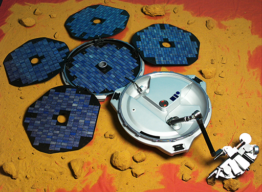
Beagle 2 was due to land on the martian surface on 25 December 2003, but no signal was detected from Earth and it was considered lost. However, in 2015 it was observed in images taken by NASA’s Mars Reconnaissance Orbiter. It had landed as planned, but not all of its solar panels, which should have provided power for its instruments, had successfully opened. This meant that the radio antenna to be used for communications with Earth was uncovered and could not transmit or receive data.