
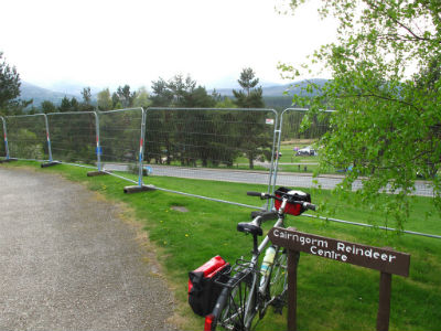
 The Cairngorm Mountains in the north-eastern highlands of Scotland gained National Park status in 2003. The area has been popular as a destination for outdoor activities for many years, and especially since the establishment of the Ski resort on Cairn Gorm mountain near Aviemore in 1960. Its popularity as a tourist destination has continued to grow further since becoming a National Park. In addition to skiing and snowboarding, the increasing popularity of activities such as hill walking, wildlife tourism and mountain biking has meant annual visitor numbers now reach around 1.5 million a year. The National Park features prominently in the advertising campaigns of the former Scottish Tourist Board ‘Visit Scotland’ and its combination of popularity and marketable visual appeal has further emphasised the need to protect and conserve the landscape of the area.
In response to the area’s growing popularity, the Cairngorms National Park Authority (CNPA), along with two partner organisations, produced a ‘Landscape Character Assessment’ document in 2009, designed to ‘produce an accurate and detailed description of the landscape types’ within the Cairngorms National Park. From this assessment a planning framework and set of guiding ‘landscape principles’ have been developed. They have been further refined into an on-line ‘landscape toolkit’ described by the CNPA as ‘a resource to help developers and professionals as well as anyone with a keen interest in learning more about Cairngorms landscapes’.
As a geographer interested in understandings of landscape the ‘landscape toolkit’ provides an intriguing example of how landscape, as a concept, provides a particular challenge to policy makers. The need to measure and quantify a landscape for planning and conservation purposes can often come into tension with slightly more hard-to-pin-down, but nonetheless significant meanings such as ‘beauty’, ‘belonging’ and ‘connectedness’. Of course the CNPA are well aware of the challenges of successfully achieving this balance and the toolkit shows how they aim to capture some of these elusive meanings in the things they seek to measure.
The toolkit is subdivided into three related sections: ‘landscape areas’ which seeks to highlight the topographic ‘character’ within separate subdivided areas of the National Park, ‘landscape sensitivity’ which seeks to measure the vulnerability of different areas to a variety of possible changes, and ‘landscape qualities’ which encompasses a process of ‘mapping the relative contribution that different features and characteristics make to the landscape’.
To take the latter ‘landscape qualities’ section as an example, in one sense this is a somewhat mechanistic process of sub-dividing the National Park into ‘types’ of area, such as ‘designed landscapes’ which are then further subdivided into mappable and quantifiable features such as ‘lodges’, ‘monuments’ and even ‘gate posts’. These features are then mapped using Geographical Information Systems (GIS) to create a map divided into differently shaded areas that indicate the number of such features within them. However as well as quantifying the landscape in this way, the section also attempts to document its ‘special and evocative qualities’. Similarly, the ‘landscape areas’ section of the toolkit seeks to quantify land use and structural development whilst also capturing a sense of how the landscape ‘is experienced’.
So, what does the Cairngorms ‘landscape toolkit’ tell us about how we can make sense of landscape and its meaning? Landscapes are something we map and measure but they are also something we can feel and experience. They are physical and topographic yet they also capture ‘more-than-physical’ qualities. This signals a complex relationship between people and landscapes which presents a significant challenge to the CNPA, as it has done for geographers studying landscape over recent decades.
Prior to the 1980s geography commonly considered landscape to be a description of physical, topographical landform. From the late 1980s and into the 1990s a greater focus became placed on the representational qualities of landscapes. In other words, a landscape (and in particular, the landscapes of fine art and photography) could represent a wider story of meanings such as national identity and how different social groups became associated with or excluded from such stories. It highlighted how landscapes could tell us about cultural values and how they served to create particular, selective understandings of ‘nature’. Then, since the late 1990s, many geographers have sought to suggest that something important has been lost in this keen focus on the ‘representational’ qualities of landscape. Many contemporary researchers propose that the meaning of landscape is more usefully understood to be generated in the relationship between humans and landscape as it is experienced through practices, such as mountain biking or wildlife watching. In this sense the meanings of landscapes exist in the practices, processes and experiences of the people within them.
So the CNPA and many geographers seem to share a view that central to the job of understanding what landscape means is an acknowledgment of its ‘evocative qualities’ and the ways it ‘is experienced’. Both suggest that detailed understandings of meaning and experience are valuable instruments for carrying out practical work. We know landscapes are evocative and affecting but how can this become more effectively acknowledged in the policy and practice of conservation, farming and tourism? This is where the research of cultural geographers looking at landscape, space and place can help to inform such considerations. The challenge that remains for the CNPA is to ensure that they are equipped with the right tools for the job.
Explore more...
-

Geography Matters: A Collection
Watch now to access more details of Geography Matters: A CollectionWant to find out more about Geography and Environmental Studies at The Open University?
Level: 1 Introductory
-

Seeing the internet
Read now to access more details of Seeing the internetHow do we see the internet? Gillian Rose explores why some artists and campaigners think it's important that the internet is made more visible.
Level: 1 Introductory
-
The Legacy of Nuclear Power: Part 1
Listen now to access more details of The Legacy of Nuclear Power: Part 1How do local communities respond to the risks and opportunities of nuclear power?
Level: 1 Introductory
-

‘Citizen sensing’ and new forms of environmental monitoring
Read now to access more details of ‘Citizen sensing’ and new forms of environmental monitoringWhat technological challenges are faced by communities seeking to understand environmental change at different geographical scales?
Level: 1 Introductory
Rate and Review
Rate this audio
Review this audio
Log into OpenLearn to leave reviews and join in the conversation.
Audio reviews