1 Reading maps
1.1 What makes a map?

During 1999 The Millennium Mapping company launched a project that planned to change the way we looked at and record the UK. The intention was to take imagery of the entire country thus producing an immediate snapshot of life in the new Millennium. In many ways this imitated the Domesday Book of 1089 when William the Conqueror attempted to record all aspects of his new kingdom.
The Millennium Mapping company, unlike William, produced more than 56,000 aerial photographs that have subsequently been updated as well as being made available to the public from their associated website (http://www.getmapping.com [Tip: hold Ctrl and click a link to open it in a new tab. (Hide tip)] [accessed 21 Dec 2006])
Indeed since that time they and many other companies have also captured aerial photography and satellite imagery that is now in regular use by public utilities, insurance companies and other private enterprises. Some companies also market historical aerial photography that offer us a different perspective: what was located in a particular place, say, before the second world war?
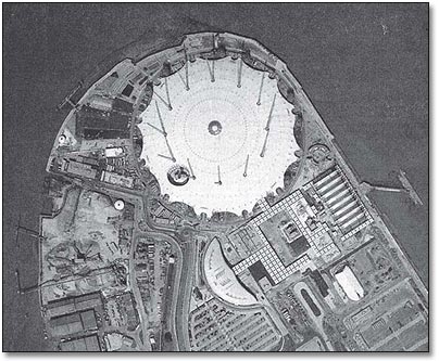
The illustration in Map 1, showing the Greenwich peninsula in London, gives us a birds eye view of an infamous building – the so-called Millennium Dome. In its relatively short life it too has made history.
The illustration, however, looks like a photograph. What is the difference between an aerial photograph and a map? Our maps are now being produced from photographs and satellite images and we will be able to construct our own maps using these. Does this therefore mean that maps have become objective and value-free?
