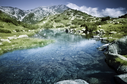
Week 6: Fragile ecosystems
Use 'Print preview' to check the number of pages and printer settings.
Print functionality varies between browsers.
Printable page generated Sunday, 14 June 2026, 11:35 AM
Week 6: Fragile ecosystems
Introduction
We bring the last five weeks together, looking at issues of large scale management and conservation, concluding with a study of the Galápagos archipelago World Heritage Site.
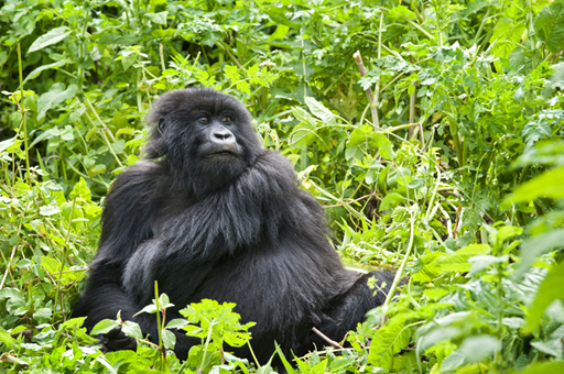
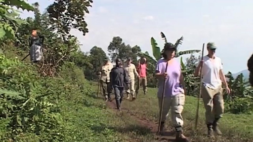
1 Gorillas and tourism
Bwindi Impenetrable National Park in Uganda was formed in an attempt to protect the jungle in the area, one of Africa’s richest ecosystems, from human activities. Initially it was preserved in a hostile way, with local residents forcibly evicted and barred from future entry into the park. This sparked angry protest from local communities, and there were violent clashes as a result.
An integrated conservation development programme was conceived to protect the area without alienating local communities, who had been dependent on the resources available in the forests and jungle for their livelihood.
Transcript
Gorillas and tourism
Contributors to this video include G. Kalema-Zikusoka, T. Yese, C. Bwiza, J. Byamukama, M. Mapesa.
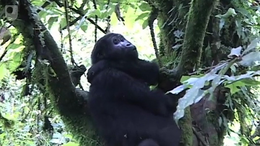
The Bwindi population of mountain gorillas is one of only two known. The population in Virunga national park in the DRC (Democratic Republic of Congo) has recently been surveyed, since the video was made. A census of the population in Bwindi was started in 2018. The previous census in 2012 showed that there were over 400 individuals. In the Virunga national park the 2018 census showed that there were 604 individuals in 41 social groups. This is an increase on the 2010 census figure of 480. So, although these figures are encouraging, around 1000 mountain gorillas in two locations represent a species and ecosystem in extreme danger. As a comparison, the populations of the critically endangered Western lowland gorilla are estimated to total 100,000 individuals.
The population census of the mountain gorillas is being carried out by teams of researchers. They search the trails used by gorillas and the areas in which the animals ‘nest’ at night. Fecal samples are collected so that DNA analysis can be carried out to determine the individual’s identity and their relationship with other social groups. The researchers also record family movement patterns. Of course, while the researchers are working they are looking out for poaching activities.
The crucial point of the development programme was to involve communities in the increased tourist interest in the park and its gorilla population.
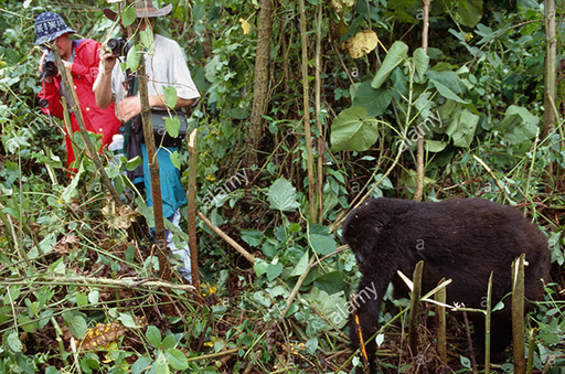
As you watch the next film, reflect on why the Bwindi Park was established, and how this affected the local population. What difference has the establishment of the park made to the ecosystems there? Consider whether the economic activities around the park make enough of a difference to the local communities around the park
Transcript
Gorillas and tourists
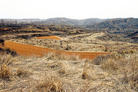
2 China’s Loess Plateau
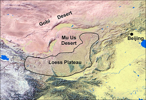
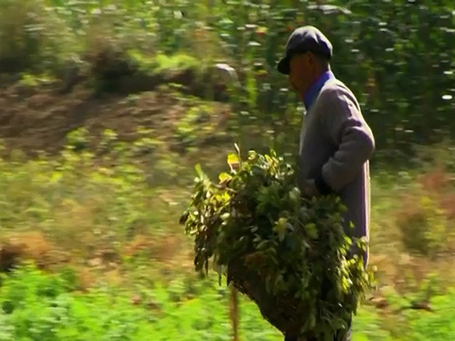
China’s Loess Plateau is a region that stretches for 640,000 square kilometres across north central China. It is an example of an ecosystem that has been ravaged by human activities, such as agriculture.
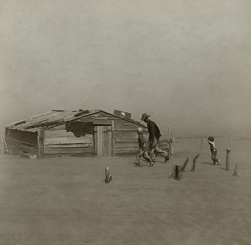
In 2015, The UN (United Nations) produced a report on food and agriculture which found that one third of the planet’s soils are damaged. Erosion, contamination and saltwater have all taken their toll. This is not a new phenomenon. In 1900 agriculture on the Great Plains of the US (United States) expanded substantially. In doing so it depleted the soil of moisture so that when, in the 1930s, there were several prolonged droughts, the dry soil was swept away by wind. Dust storms disrupted life and ruined farmland.Start of Media Content
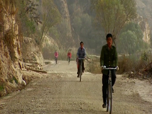
The Loess plateau suffered in a similar way. In 1994 a programme of restoration began. The following videos show some of the actions taken by China to restore the plateau ecosystem, with help from the World Bank. As a result of the restoration programme millions of people benefited, although the costs were high – US$500 million.
Transcript
China’s Loess Plateau
Contributors to this video include John D Liu.
Video: ©co-produced by The Open University and EEMP for BBC World, with support from the International Union for the Conservation of Nature (IUCN), The Open University, The Rockefeller Foundation, and the Syngenta Foundation for Sustainable Agriculture and The World Bank. © Environmental Educational Media Project (EEMP) 2009
The hills and valleys of China’s Loess Plateau eroded because grazing domestic animals denuded them of vegetation. Valuable soil was washed away into the nearby Yellow River, leaving the plateau unfertile.
The rehabilitation of the plateau has been a slow and arduous task. As you watch the next video think about the following questions:
- What were the activities that resulted in the destruction of the Loess Plateau?
- What actions were taken to restore the plateau?
Transcript
Loess Plateau’s success
Video: ©co-produced by The Open University and EEMP for BBC World, with support from the International Union for the Conservation of Nature (IUCN), The Open University, The Rockefeller Foundation, and the Syngenta Foundation for Sustainable Agriculture and The World Bank. © Environmental Educational Media Project (EEMP) 2009
Activity 1
How can the destruction and rehabilitation of the Loess Plateau be understood in terms of an ecosystem?
Write some notes in the box below.
Answer
The Loess Plateau can be considered as a discrete ecosystem. As it became over-exploited the flow of energy through the food chains within the ecosystem changed and reduced. Unless the primary flow of energy from sunlight into plant material for consumers is maintained, the ecosystem will change in character and, as in the case of the Loess Plateau, parts can become almost barren. Several thousand years of human agriculture denuded the hills and valleys of vegetation. Domestic animals fed on vegetation and there was no chance for young trees and shrubs to grow. Rain no longer seeped into the ground but washed down the sides of the hills carrying away soil. Thus the primary route for energy to enter the ecosystem disappeared.
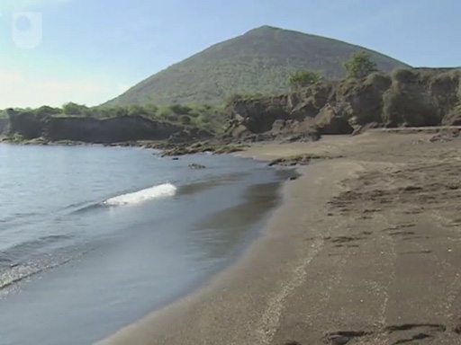
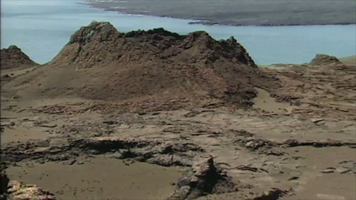
3 Galápagos
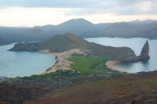
The Galápagos archipelago is a unique ecosystem with a diverse collection of island habitats. It is a World Heritage Site and many of the plant and animal species are found nowhere else. The islands also have historical significance in the development of biological science, following the visit by Charles Darwin in 1835. The islands had a profound influence on his ideas about species formation, which culminated in his book On the origin of species by means of natural selection (1857).
The islands have been the focus of scientific research for many years, but the conservation problems are substantial. This week the course will feature a series of video portraits about the archipelago. This series of portraits of the islands highlights the biodiversity found there, the problems of invasive species, the value of the islands for research and the problems of maintaining a flourishing ecosystem. As you watch the videos, think about these questions and take notes that will help you to answer them.
- Bearing in mind the definition of an ecosystem that you encountered at the start of this journey, is it reasonable to regard the whole archipelago as an ecosystem?
- What tensions arise between keeping the islands pristine, allowing visitors and allowing colonisation from the mainland?
- What major threats to the integrity of the habitats on Galápagos can you identify? Are they peculiar to the islands or applicable to ecosystems in general?
3.1 Darwin’s arrival on the Galápagos Islands
Although it is possible to follow in Darwin’s footsteps, as Dr David Robinson demonstrates in this video, the habitat has changed substantially as a consequence of the introduction of alien animals in the past. There are very few of the larger islands where you can see ecosystems unaffected by alien introductions and thus see them as Darwin saw them.
Transcript
Darwin’s arrival on the Galápagos Islands
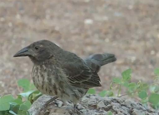
The finches that Darwin brought back from the Galápagos hold a special place in the history of the development of the theory of evolution by means of natural selection. There are 13 species and they occupy different niches in the habitats on the islands.
Transcript
Finches on Galápagos
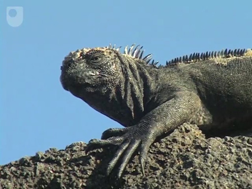
3.2 Darwin’s thoughts on the iguanas
The marine iguanas of the Galápagos are the only marine lizards and occur nowhere else. They occupy a fragile ecosystem that is very vulnerable to changes in sea temperature. There is also a species of land iguana on the islands.
Transcript
Darwin’s thoughts on the iguanas
Activity 2
Why, do you think, is the marine iguana so vulnerable to sea temperature changes?
What impacts of environmental change might make the land iguana vulnerable?
Answer
The marine iguana feeds exclusively on a small number of species of seaweed. The seaweed needs relatively cool water and in some years, when the ocean currents reverse, the seas around the islands get too warm for the seaweed and it dies back. The marine iguanas then have no food and die in large numbers. Any prolonged warming of the seas would make the species highly vulnerable to extinction. Land iguanas get most of their water from prickly pear cacti and the rest from rain fall. Any prolonged period without rain due to changes in climate put land iguanas at risk.
3.3 Invasive alien species
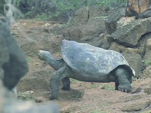
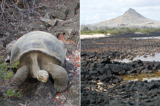
Alien species represent a major threat to ecosystems and this is particularly significant for oceanic island groups. The tortoises that gave the Galápagos islands their name are now threatened by alien introductions. Goats have been a particular problem, but slowly the populations have been brought under control. The habitat, the wariness of goats and remoteness of the islands make eradicating goats a very expensive proposition.
Transcript
Goats compete with tortoises
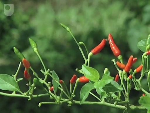
Like the animals on the Galápagos, much of the flora of the islands is also vulnerable to the impacts of introduced alien species. Up to 2017, 821 terrestrial plants had been introduced. Among the most devastating has been the red quinine tree.
Transcript
Eradicating the red quinine plant
3.4 How do invasive alien species reach the Galápagos islands
The impact of an invasive alien species can be dramatic. The islands will only retain their unique biodiversity if the routes by which aliens can enter the islands can be identified and managed. The Galápagos Conservation Trust produced a summary diagram in 2019 which shows the extent of the problem of alien species. The diagram is based on figures published in 2017.
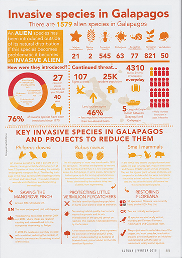
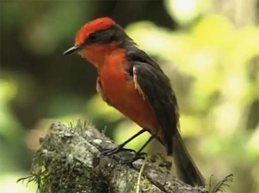
The vermillion flycatcher provides an example of an endangered species that is rapidly declining. The species is endemic to the Galápagos. It lives in the native Scalesia forest, but that forest is disappearing as an introduced plant, the hill raspberry spreads and prevents the Scalesia forest from regenerating. An alien parasitic fly that lays it’s eggs in the nests of small birds may also contribute to the decline in the flycatcher population. The larvae that hatch then feed on the blood of the nestlings. Mortality is often 100%.
Areas of land are now being cleared of invasive plants to allow the native plants to recover and thus provide a habitat for the insect populations that the flycatcher feeds on.
3.5 Galápagos research and human effects
Most of the animals and birds on the islands have no fear of humans, which is one of the reasons why the islands are such an attractive place to carry out research.

Transcript
Galápagos research
This video highlights the pressures of increasing tourism and increasing population. Since the video was made, an area of land close to Puerto Ayora, the main town on Santa Cruz, has been set aside for 1200 new houses, which will double the size of the town. The Prince’s Foundation for Building Community has been working with local people and the Galápagos Conservation Trust to produce building codes for sustainable housing.
Transcript
Managing tourism in the Galápagos Islands
3.6 A fragile ecosystem
Before you started watching this week’s videos about the Galápagos you were asked to consider three questions. You should now be able to answers them and set them in the context of your overall study of ecosystems.
Activity 3
Answer the questions in the box below.
- Bearing in mind the definition of an ecosystem that you encountered at the start of this journey, is it reasonable to regard the whole archipelago as an ecosystem?
- What tensions arise between keeping the islands pristine, allowing visitors and allowing colonisation from the mainland?
- What major threats to the integrity of the habitats on Galápagos can you identify? Are they peculiar to the islands or applicable to ecosystems in general?
Answer
The islands are probably best regarded as individual ecosystems but the marine environment around the islands might be considered as a single, separate, ecosystem. As you learnt earlier, the physical boundaries of an ecosystem are influenced by the definition that you adopt and it would be possible to argue that for a definition in terms of energy flow, the whole archipelago is a single ecosystem.
Keeping the remaining pristine islands in pristine condition can be done by not allowing access, but it is difficult to prevent humans landing on islands and patrols to keep intruders at bay would themselves compromise the pristine nature of the islands. Another factor to consider is the money that visitors bring. Would they be so keen to contribute money if they couldn’t visit?
The threats to the integrity of the habitats fall into three broad categories. Human activity and population growth is an obvious one that effects the islands and it is a global factor. Alien introductions of plants and animals have wrought havoc in the past and can do so in the future. They are a risk to all ecosystems but the Galápagos are particularly vulnerable. Finally, global climate changes or volcanic activity could change the habitats on the islands.
4 End of course quiz
This is a longer quiz so you can check your understanding of the whole course.
Take the end of course quiz now.
5 Conclusion
Dr David Robinson, Lead Educator and Senior Lecturer in Biological Science at The Open University, discusses and summarises the contents of this course, and the skills and knowledge you will have gained from it.
Your journey has taken you to a variety of places, from Wicken Fen in Britain to the Bwindi Impenetrable National Park in Africa; from the Loess Plateau in China to the Pacific Islands of the Galápagos. These places have shown you a variety of different ecosystems, but there are two common themes: conservation and restoration. Neither of these activities can be undertaken without a very clear understanding of the ecosystems themselves.
At the start of this course three over-arching questions were posed. You should now be able to answer those questions.
‘What is the importance of understanding ecosystems, how do they work and how crucial is their conservation?’
Transcript
Conclusion
6 Beyond ecosystems
Well done for completing Introduction to ecosystems. If you have studied the full course and completed all the quizzes you will receive a Statement of Participation certificate as a record of your achievement. You can access and print it from your MyOpenLearn profile.
If you would like to learn more about natural history in general, here are some possibilities:
Explore OpenLearn further:
- Ecosystems: Taking it further
- Woodlands – in our Neighbourhood Nature course
- Polar regions – using our Frozen Planet interactive
- The Galápagos World Heritage Site – by listening to our podcasts
Continue your membership of the iSpot community and contribute your observations at www.ispotnature.org/.
Contribute to the UK national map of trees at treezilla.
Good luck with your learning.
Now you've completed the course we would again appreciate a few minutes of your time to tell us a bit about your experience of studying it and what you plan to do next. We will use this information to provide better online experiences for all our learners and to share our findings with others. If you’d like to help, please fill in this optional survey
Acknowledgements
Except for third party materials and otherwise stated (see terms and conditions), this content is made available under a Creative Commons Attribution-NonCommercial-ShareAlike 4.0 Licence.
The material acknowledged below is Proprietary and used under licence (not subject to Creative Commons Licence). Grateful acknowledgement is made to the following sources for permission to reproduce material in this course:
Course image: courtesy of Dr. David J. Robinson, The Open University
Figure 1: kemo1980/iStockphoto.com
Figure 2: guenterguni; iStockphoto.com
Figure 3: Steve Davey Photography; courtesy of Alamy
Figure 4: Paul Kapp/ University of Arizona Department of Geosciences
Figures 5 and 6: courtesy of Dr. David J. Robinson, The Open University
Figure 7: Galapagos Conservation Trust; http://creativecommons.org/licenses/by-nc-sa/3.0/
Audio/Video
China’s Loess Plateau: Environmental Educational Media Project 2009 (EEMP)
Every effort has been made to contact copyright owners. If any have been inadvertently overlooked, the publishers will be pleased to make the necessary arrangements at the first opportunity.
Don't miss out:
1. Join over 200,000 students, currently studying with The Open University – http://www.open.ac.uk/ choose/ ou/ open-content
2. Enjoyed this? Find out more about this topic or browse all our free course materials on OpenLearn – http://www.open.edu/ openlearn/
3. Outside the UK? We have students in over a hundred countries studying online qualifications – http://www.openuniversity.edu/ – including an MBA at our triple accredited Business School.