Use 'Print preview' to check the number of pages and printer settings.
Print functionality varies between browsers.
Printable page generated Friday, 12 June 2026, 5:35 AM
Chapter 1 Water resources in Myanmar
1.1 Introduction
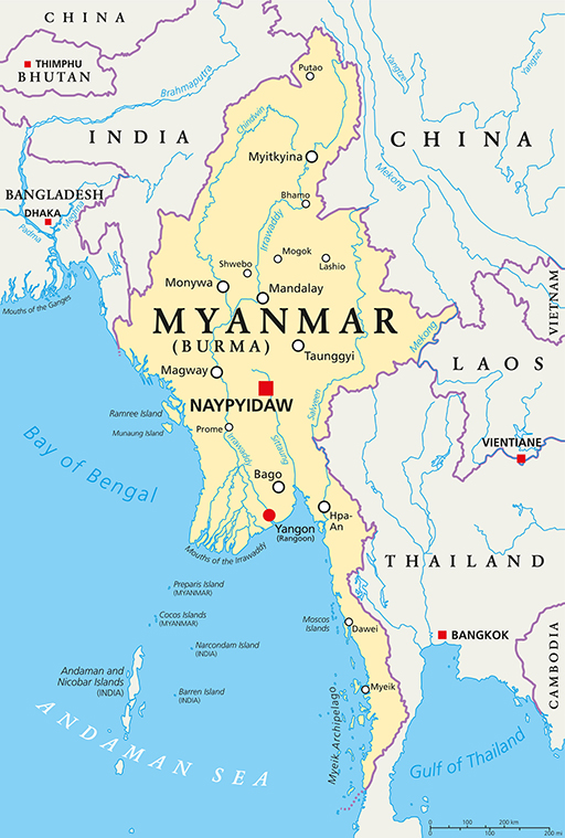
Myanmar is a Southeast Asian country with a total area of 676,590 km2 and a coastline that is 2,400 km long (Aquastat, 2014). The topography of the country is varied. It is hilly and mountainous in the west, north and east, has a semi-arid dry zone in the centre, a long coastline in the west and alluvial plains in the southern delta. The country’s southern coastline lies on the Andaman Sea and to the southwest of the Bay of Bengal.
It is divided into seven states mainly covering the hill regions of Chin, Kachin, Kayah, Kayin, Mon, Rakhine and Shan, and seven regions – covering the plains, Ayeyarwady, Bago, Magway, Mandalay, Sagaing, Tanintharyi and Yangon. It is bordered by Bangladesh to the west, India to the northwest, China to the northeast, and Laos and Thailand to the east.
Myanmar has abundant water resources, with eight major river basins that cover 90% of the country’s territory as well as sizeable lakes. It processes 12% of the whole of Asia’s fresh water resources and 16% of the fresh water of the ASEAN nations (Thang Sein, n.d). But despite this, the growing demand for water use due to population growth, urbanization and industry poses challenges to water security.
This chapter explores Myanmar’s water resources, where they are, their availability and how they are subject to seasonal variability.
1.2 What are water resources?
A natural resource is something that comes from the natural environment that people can use. Water is a natural resource, as is air, coal, oil and natural gas, among others. Water resources come in many forms, but the three main categories are saltwater, groundwater and surface water.
The major uses of water are agricultural, industrial and domestic use.
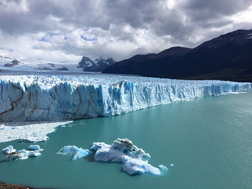
Natural resources like water are not only used by people, but by all living things that require water to grow and reproduce. 97% of the water on the Earth is saltwater and only 3% is fresh water, and it is this fresh water that is vital for people and other living organisms’ survival and health. Of this 3%, slightly over two thirds is frozen in glaciers like in Figure 1 and the polar ice caps and so is not easily accessible. The remaining less than 1% of unfrozen freshwater is what is available for use.
Question 1
a.
57%
b.
63%
c.
68%
d.
71%
The correct answer is d.
Feedback
Earth is a very wet planet. Water covers 71% of its surface in oceans and seas. Were you close in your estimate?
Accessible fresh water is in the form of surface water and groundwater. Water from precipitation (rain, snow, hail, sleet) falls on the land and runs over the surface collecting in rivers, streams and lakes, and ultimately drains into oceans. This is called surface water.
But sometimes the water that falls as precipitation, instead of running over the surface, begins to interact with the land, in particular the soil, infiltrating the soil, percolating (slowly trickling downwards) through the soil layers, rocks and sediment, deeper and deeper until it reaches conditions where the rocks are already very wet, or saturated, where it becomes groundwater.
The top of the groundwater is called the water table. Groundwater is fresh water located in the subsurface pore space of soil and rocks. It is also water that is flowing within aquifers below the water table. Aquifers are sections of soil and rock that hold groundwater (like rocky sponges). Water can be taken from the aquifer to the surface using wells and pumps.

Question 2
a.
Surface water
b.
Groundwater
The correct answer is b.
Answer
Groundwater is fresh water located in the subsurface pore space of soil and rocks that collects within aquifers.
Question 3
There are two types of aquifers: an unconfined aquifer and a confined aquifer. An unconfined aquifer is where water seeps from the ground surface directly into the aquifer. A confined aquifer is where an impermeable rock layer prevents water from seeping into the aquifer from the ground surface directly above it. Instead, water travels down and across and eventually seeps into an unconfined aquifer farther away where the impermeable layer does not exist, often travelling large distances.
Question 4
a.
A confined aquifer
b.
An unconfined aquifer
The correct answer is b.
Feedback
An unconfined aquifer potentially gives the cleaner water because it has travelled less far, and therefore is less likely to be contaminated.
Sometimes it is useful to make a distinction between groundwater that is closely associated with surface water in rocks and soils, and deep groundwater, which is an ancient body of water that has been contained in some undisturbed space, such as subglacial lakes or aquifers, and may have laid there for millennia (sometimes called fossil water).
The level of the water table varies not only across the planet, but also in any one place, fluctuating up and down depending on the season, climatic conditions and pressure from people. People can pump groundwater for agriculture, industry or domestic use. In areas that have shallow water tables (near the surface), sometimes the water table connects to the lakes and rivers.
Question 5
a.
To be deep
b.
To be near the surface
The correct answer is a.
Feedback
In very dry areas, the water table is deep because any water that falls on the land seeps through the dry rocks and sediments a long way before it finds saturated rocks, the water table. In wet areas, there is a lot of precipitation, which means the soil and rocks get saturated nearer the surface. Therefore, the water table is higher.
A further distinction is between renewable water resources and non-renewable water resources. Renewable water resources are rechargeable due to the hydrological cycle (water cycle), unless they are overexploited, comprising groundwater aquifers and surface water like rivers and lakes. Non-renewable water resources are not replenished at all or not for a very long time. This includes the so-called fossil waters.
1.3 The hydrological cycle or water cycle
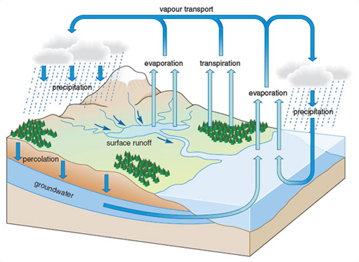
The hydrological cycle, which is also called the water cycle, is the process where water is recycled again and again between its stores. It starts with precipitation, which is the delivery of water from the atmosphere to the Earth's surface. Precipitation happens as a result of condensation, where water molecules in the clouds condense into larger and larger water droplets. When they have enough mass, they start to fall out of the sky as rain, sleet, hail or snow arriving on the Earth’s surface.
Of this water, some will infiltrate into soils where it can be taken up by plant roots. Plants send this water up through their stems, and deliver it from their leaves back into the atmosphere. This process is called transpiration.
Some water will evaporate back into the atmosphere because the water is heated up so the water molecules change from liquid to gas. This process is called evaporation and happens on land, rivers, lakes and oceans. Together these processes of transpiration and evaporation are called evapotranspiration. However, some water that falls on land percolates through the soil, and collects in aquifers as groundwater.
Other water will actually flow over the land surface into rivers, streams, lakes and oceans.
Question 6
Two lists follow, match one item from the first with one item from the second. Each item can only be matched once. There are 3 items in each list.
Transpiration
Evaporation
Evapotranspiration
Match each of the previous list items with an item from the following list:
a.What is the process called where water is transferred from the land to the atmosphere by evaporation from the soil and other surfaces and by transpiration from plants?
b.What is the process called where precipitation returns back to the atmosphere because the water sits on soils and is heated up so that the water molecules change from liquid to gas?
c.What is the process called by which plants take up water that infiltrates soils and return it to the atmosphere?
- 1 = c,
- 2 = b,
- 3 = a
Internal renewable water resources comprise the average annual flow of rivers and groundwater generated from precipitation that falls within a country. Surface water and groundwater can be thought of as having inputs, outputs and storage. The natural input for surface water is precipitation. The outputs are the release of the water back to the ocean, either through river discharge, or back to the atmosphere through evaporation.
Surface water is stored by being intercepted by plants, and accumulating in lakes and rivers, as well as through infiltration and percolation to be stored as groundwater. The natural input to groundwater is this seepage from surface water. The natural outputs from groundwater are springs and seepage to the oceans.
Groundwater storage is generally much larger (in volume) than surface water because of its slow rate of turnover. This difference makes it easy for humans to use groundwater unsustainably for a long time without severe consequences. Moreover, in coastal areas, human use of groundwater may cause the direction of seepage to the ocean to reverse, which can cause soil salinisation.
Humans can also cause groundwater to be "lost" (i.e. become unusable) through pollution. Humans can increase the input to a groundwater source by building reservoirs or detention ponds.
Question 7
a.
True
b.
False
The correct answer is b.
Feedback
The water table within any region fluctuates up and down, depending on the season and depending on what sort of pressures that water table is under.
1.4 Water Resources in Myanmar
Myanmar is a country in a favourable situation with respect to water resources. There are only a few trans-boundary rivers, which means that virtually all water resources are within the national borders. Abundant water resources mean there is substantial scope for their development. The major river basins cover large areas of Myanmar and provide natural resources for many livelihood sectors. Myanmar is identified as a country with abundant water resources, but with marked seasonal and regional variability.
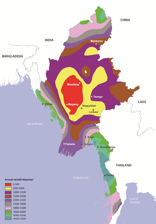
The mean annual rainfall, which is how water resources are renewed, is around 2,100 millimeters, but this varies from as high as 5,000 millimeters along the coastal areas of Rakhine and Tanintharyi states to less than 1,000 millimeters in the Central Dry Zone (ADB, 2017). Total renewable annual water resources are estimated at 1,100 cubic kilometers. The renewable water resources per capita (the total sustainable water available per inhabitant) is about 19,000 cubic meters per year (Kingdom of the Netherlands, 2016). This is Myanmar’s water endowment.
A country with an annual per capita water endowment of less than 1,700 cubic meters is considered to be under water stress. Myanmar’s water endowment is about 9 times the available levels in China, 16 times India, 5 times Vietnam and 16 times Bangladesh (Kingdom of the Netherlands, 2016). However, despite Myanmar’s generous water endowment, only 5% is currently used.
Question 8
Use the image in Figure 4 to answer these questions
Two lists follow, match one item from the first with one item from the second. Each item can only be matched once. There are 5 items in each list.
Magway
Dawei
2000-2500 millimeters
0-500 millimeters
500-1000 millimeters
Match each of the previous list items with an item from the following list:
a.What is the annual rainfall for Mandalay?
b.What city is in the driest part of Myanmar?
c.What is the annual rainfall for Yangon?
d.What city is in the wettest part of Myanmar?
e.What is the annual rainfall for Nayphidaw?
- 1 = b,
- 2 = d,
- 3 = c,
- 4 = a,
- 5 = e
1.4.1 River basins
A river basin is the area of land that is drained by a river and its tributaries. There are eight major river basins in Myanmar.
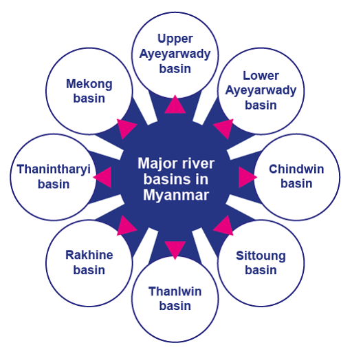
The Ayeyarwady and the Thanlwin basins are the largest. The river basin characteristics vary considerably due to the climatic conditions and physical features in Myanmar. The Ayeyarwady basin covers the central plains and the southern delta area that represent the most important croplands of the country and are the most intensively populated areas in Myanmar.
In the central valley in the Ayeyarwady basin, which is the Dry Zone of the country, irrigation is essential for cultivation. The Thanlwin River provides very little riverine flat land for cropping, but has large hydropower potential.
The main water resources for the Central Dry Zone in Myanmar are influenced by the climate and seasonal rainfall. Mean annual rainfall in the Dry Zone ranges from 500 to 1,000 mm. This is low compared to the 2,000–5,000 mm range received by the rest of the country.
Mean, median, mode and range
Mean, median, and mode are three kinds of "averages".
The "mean" is the "average" you are probably used to, where you add up all the numbers and then divide by the number of values.
The "median" is the "middle" value in a list of numbers. To find the median you have to write out the numbers in numerical order from the smallest to the largest. The median is the middle number, and where you have an even number of total numbers, you take the two medians if they are different, add them together and divide by two (so effectively you find the mean of the two medians).
The "mode" is the value that occurs most often. If no number in a list is repeated, then there is no mode for the list.
The "range" of a list of numbers is just the difference between the largest and smallest values.
Question 9
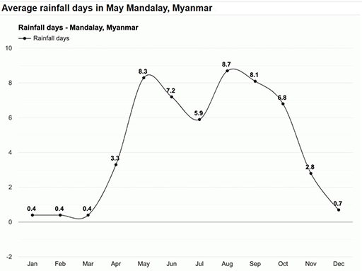
Above are the average monthly daily rainfall records for Mandalay.
The Ayeyewady River and its tributaries dominate surface water resources in the Central Dry Zone. The Chindwin River is the major tributary of the Ayeyewady River; other significant tributaries are the Mu, Shweli and Myitnge. These rivers provide water for irrigation and, in some places, recession agriculture, where farmers capitalize on natural flows and sediments to irrigate and fertilize crops on floodplains. A floodplain is an area of flat land next to a river, formed mainly of river sediments and subject to flooding.
However, some of the river courses are deeply incised into the landscape, so water for irrigation can only be obtained by pumping. Given the seasonal nature of rainfall, communities need to retain and store rainwater and runoff received during the wet season for use in the dry season.
There is a widespread view that the groundwater reserves of the Central Dry Zone are vast and largely unexploited. Groundwater quality would appear to be fit for general purposes over large parts of the Dry Zone. It is generally of low to moderate salinity (typically 1,000 to 2,000 μScm), although brackish to saline groundwater is found, in particular, in the western and delta areas.
Water and soil salinity
It is not only water that takes up salt becoming brackish or saline. Soil does too. Salinity in water and soil is measured by passing an electric current between two electrodes of a salinity meter in a sample of soil or water. The electrical conductivity or EC of the sample is influenced by the concentration and composition of dissolved salts. Salts increase the ability of a solution to conduct an electrical current, so a high EC value indicates a high salinity level.
The level of salinity is measured in a number of ways, but the most common are in EC units, or μScm (micro Siemens per centimetre). These have equivalent values, so 1,000 to 2,000 μScm is the same as 1,000 to 2,000EC.
In addition, there are two major natural lakes in Myanmar, which are Indawgyi Lake in Kachin State and Inle Lake in Shan State. Indawgyi Lake is one of the largest inland lakes in Southeast Asia, measuring 24 km long and 13 km wide.
Inle Lake is the second largest lake in Myanmar at 22km long and 10 km wide. The watershed area for the lake lies to a large extent to the north and west of the lake. The main business in this region is agriculture with the floating gardens. Both lakes are part of biosphere reserves that includes the lake and the surrounding wetlands and forest.
Biosphere reserve
A biosphere reserve is an ecosystem with plants and animals of unusual scientific and natural interest. It is a label given by UNESCO to help protect the sites. They are sites for testing interdisciplinary approaches to understanding and managing changes and interactions between social and ecological systems, including conflict prevention and management of biodiversity (UNESCO, 2020).
An ecosystem is a biological community of interacting living organisms and their physical environment. The living and physical components are linked together through nutrient cycles and energy flows. Ecosystems can be of any size, but usually they are in particular places. They regulate essential ecological processes and support lives.
1.5 Managing the availability of water resources in Myanmar
The catchment area of Myanmar’s rivers comprises about 737,800 km². The potential water resource volume is about 1082 km³ for surface water and 495km³ for groundwater (WEPA, 2018). Most of the irrigation reservoirs are sited on the tributaries and streamlets of the main water resources. In the reservoirs and lake areas, deteriorating water quality and excessive sedimentation are the main challenges.
In order to understand the availability of water in Myanmar, the country can be divided into three agro-ecological zones – the coastal zone, the Central Dry Zone, and the hilly zone as shown in Figure 6.
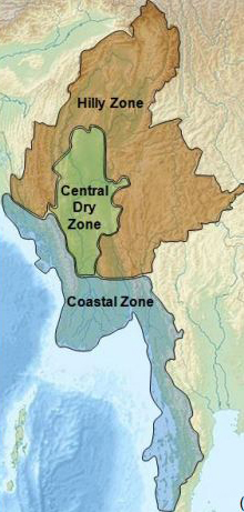
The Coastal Zone
Myanmar has a very long coastline at 2,400km. Along its west coast, it borders the Bay of Bengal and the Andamen Sea. This makes it subject to frequent tropical storms and cyclones during October to December with a secondary peak from April to May. These cyclones are making landfall more regularly and with increasing severity as shown by the devastation of Cyclone Nargis in May 2008. Myanmar’s coastline is also very vulnerable to rising sea levels as a result of climate change.
The extension of agriculture and aquaculture in the coastal regions has led to the cutting down of mangroves which are invaluable for the marine ecosystem and coastal protection. Aquaculture is the breeding, rearing, and harvesting of fish, shellfish, algae, and other organisms in all types of water environments. It is basically farming in water, rather than on land. There are two main types of aquaculture – marine and freshwater. In the Ayeyarwady delta alone only 14% (relative to 1925) of the original mangrove forests survive (Government of Myanmar, 2014). The main challenge here is to build dykes and drainage canals in these low-lying reclaimed coastal areas, a process known as poldering.
The Central Dry Zone
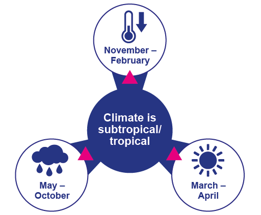
The agricultural productivity of this region is crucial for the country. The Central Dry Zone benefits least from the Southwest Monsoon, due to the high mountains surrounding the area, but occupies two-thirds of the agricultural land and has higher temperatures than elsewhere in the country. The climate of the Dry Zone can be divided into two periods – the wet season and the dry season.
- The wet season coincides with the Southwest monsoon and lasts from May to October.
- The dry season is divided into winter (November to February) and summer (March to April).
The Dry Zone also typically experiences a brief dry spell during the wet season also in June/July. There is a scarcity of water in the Central Dry Zone. Groundwater is crucial across the Central Dry Zone supplying water for irrigation, although it is used inefficiently with much of it is lost to the air by evaporation before it can be taken up by crops. Existing irrigation systems are also in need of upgrading and improved drainage could reduce widespread salination of the land.
Climate change is having severe impacts on agricultural production in this region, with changes in the precipitation patterns and rising temperatures increasing the likelihood of crop failures in the short-run and production declines in the long-run.
The Hilly Zone
The higher elevations of the highlands are predisposed to heavy snowfall, especially in the North. The Northern regions of Myanmar are the coolest, with average temperatures of 21 °C (70 °F). Coastal and delta regions have an average maximum temperature of 32 °C (89.6 °F).
In the mountainous area, unsustainable agriculture practices of slash and burn and deforestation are eroding slopes increasing flooding, building up sediment, impacting water supply and inland water navigability, and downstream, silting the delta area (Government of Myanmar, 2014).
All these issues suggest the urgent need for an integrated approach to water resource management to halt degradation, maximise yields and improve farmer livelihoods. You will study integrated water resource management in Myanmar in Chapter 4 of the course.
1.6 Seasonal Variation of Water Resources in Myanmar
A large portion of Myanmar lies between the Tropic of Cancer and the Equator and the entirety of the country lies in the monsoon region of Asia. Myanmar is a diverse country that exhibits different challenges. The climate is subtropical/tropical and has three seasons.
The cool winter season is followed by a hot summer season and the rainy season is dominated by the southwest monsoon.
Temperatures are increasing while the length of the wet season and monsoon are decreasing. Rainfall has also become more erratic (Tung OO et.al, 2020). Myanmar’s climate pattern is highly influenced by the monsoon. About 95% of its annual national rainfall is received from the Southwest Monsoon, from May to October, with spatial and temporal variability.
Seasonal temperatures vary throughout most of Myanmar. In the Central Dry Zone temperatures range from a maximum of 40–43 ºC in the hot/dry season to 10–15 ºC in the cool/relatively dry season and decrease to -1ºC or 0ºC at times in the highlands, but do not vary much in the south.
A shorter period of Monsoon, due to late onset and early withdrawal, will result in large quantities of rain falling over short periods, leading to flooding, contamination of water resources, erosion and more limited replenishment of waterways. Saliniation is also a threat in coastal areas. The progressive melting of glaciers may have an impact on the Himalayan region of Myanmar, which provides large quantities of water to many parts of the country.
Question 10
Two lists follow, match one item from the first with one item from the second. Each item can only be matched once. There are 2 items in each list.
Cool and dry
Hot and wet
Match each of the previous list items with an item from the following list:
a.If you were studying this course in the Central Dry Zone of Myanmar in December, what would you expect the weather to be like?
b.If you were studying this course in the delta region in the south of Myanmar in June, what would you expect the weather to be like?
- 1 = a,
- 2 = b
1.7 Conclusion
In this first chapter, you have learned about:
- What water resources are
- How the hydrological cycle explains the movement of water on the planet
- Where water resources are in Myanmar
- The availability of water resources in Myanmar and their seasonal variation.
You have discovered that Myanmar is a water abundant country, but that the water resources are not where they are needed most. Moreover, Myanmar is a country that is negatively impacted by climate change. In Chapter 2, you learn how Myanmar uses its abundant water resources.