

1 The role of soil
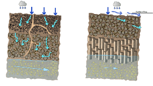
The ability of the ground surface to absorb water is called its infiltration rate. Where the ground is paved or compacted, that value is very small (often less than 1 mm of water moving through the soil per hour). Where there is vegetation growing on undisturbed soil, it can be very large (over 30 mm per hour, allowing it to absorb all but the very heaviest rainstorms). The rate of infiltration can be assessed using a ring infiltrometer pushed into the soil (see Figure 1). The rate at which the water level in the inner ring falls is measured.

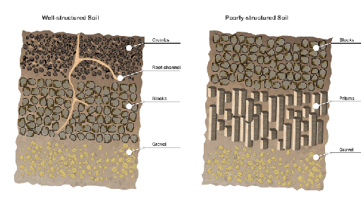
A well-structured soil, such as that within an established floodplain meadow, can consist of more than 70% void (empty space) by volume, which can be filled either with air (when dry) or with water (when saturated). This space provides a huge store for water; perhaps three million litres per hectare. Soils are therefore able to mitigate flooding by absorbing water rather than it running-off into the river. Figure 2 illustrates how open the structure of an undisturbed soil can be.
A permeable soil can absorb yet more water by transmitting it to underlying porous rocks (aquifers) from where it can move slowly at depth out to sea without ever entering a river. The amount of water stored and transmitted beneath our feet as groundwater is under appreciated.
Activity 1
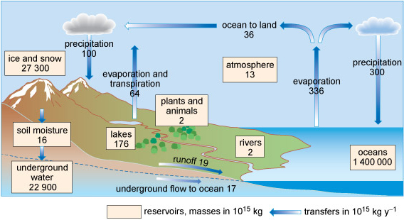
Using the numbers in Figure 3 carry out the following tasks:
- Calculate the proportion of the annual precipitation (rainfall) on land that flows to the sea over the land surface (‘runoff’, which includes all the flow in rivers and streams).
- Calculate the proportion of the annual precipitation (rainfall) on land that flows to the sea via groundwater.
- What happens to the majority of the precipitation (rainfall) on land?
Discussion
- The runoff is 19 trillion tonnes per year. The quantity of rainfall is 100 trillion tonnes per year. So the percentage of rain that runs off the land is 19/100 x 100 = 19%.
- The groundwater flow is 17 trillion tonnes per year. The quantity of rainfall is 100 trillion tonnes per year. So the percentage of rain that flows below ground is 17/100 x 100 = 17%.
- By adding the answers to part A and part B together, we get: 19% + 17% = 36% of the annual rainfall flowing to the sea. This leaves 64% going elsewhere. The diagram shows that this 64% returns to the atmosphere via evaporation and transpiration (transpiration is evaporation from plants).