
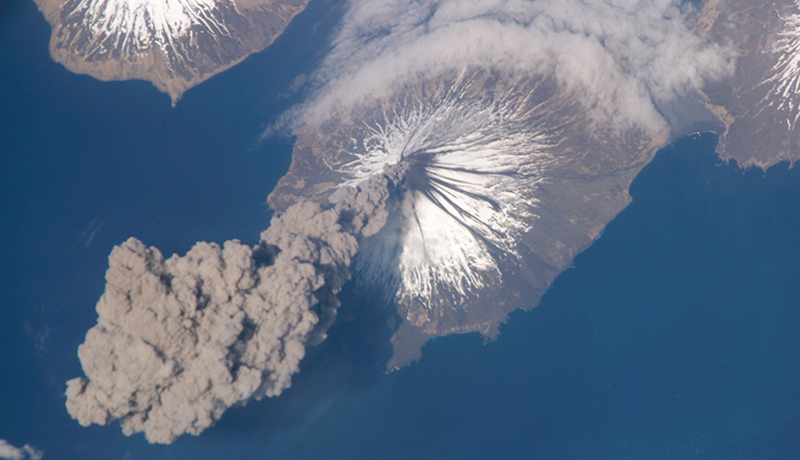
 A view from space of Mount Cleveland volcano, Aleutian Islands, Alaska (2006)
A combination of passive and active remote sensing (RS) is accepted to be a technological solution for bridging critical gaps in volcanic hazard assessment and risk mitigation. Whereas many examples of satellite-borne volcano monitoring are known since the early Eighties, we note that the exceptionally large literature available on optical (passive) remote sensing of very-high temperature features, lacks in detailed information on some key-parameters. In particular, spectral emissivity and its behaviour at high-to-very high temperatures.
What is Spectral Emissivity?
Defined as the efficiency with which a surface radiates its thermal energy – spectral emissivity is seldom measured and is mostly assumed or estimated. Nonetheless, it is a critical variable in space-borne volcano monitoring due to its close relationship with Land Surface Temperature (LST) values and the inherent impact on the estimate of mass eruption rates.
To fill this gap in knowledge, we designed a multi-stage experiment to measure spectral emissivity of rock samples collected in a grid, scaled to the spatial resolution of High-Resolution multispectral payloads provided with Thermal Infra-Red (TIR) channels – in particular, Terra’s ASTER and Landsat 8’s TIRS – from which spectral emissivity can be derived.
The aim
This approach will:
estimate the lateral spatial heterogeneity of spectral emissivity on ground at known volcanic targets
assess the capacity of reproducing it from space-borne observations at the scale of a satellite image/pixel
develop a method for incorporating the experimental laws into the techniques of automated eruption detection and quantitative monitoring.
Development of a general method
The suite of lava flow samples from Mount Etna, Italy (1999 - 2017) were investigated (spectral emissivity measured), using laboratory-based Fourier Transform Infra-Red (FTIR) spectroscopy at 0.4 to 14.5 μm wavelength range and moderate-to-high temperatures (400 K to 1000 K).
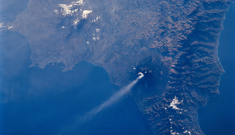 Mt. Etna on Sicily displays a steam plume from its summit (1994)
The initial investigation of spectral emissivity valuation assesses the correlation of laboratory measured data with (i) petrological composition, (ii) sample properties, and (iii) high-resolution RS data of the same target.
Measured spectral emissivity results are further used in remote sensing applications to constrain very high-temperature thermal anomalies (i.e. active lava flows with integrated pixel temperatures - close to or above 1000 K) and in melt mass flux investigations.
Like science? Go further with the OU
-
Moons of our Solar System
Learn more to access more details of Moons of our Solar SystemIn this free course, Moons of our Solar System, explore the many moons of our Solar System. Find out what makes them special. Should we send humans to our Moon again?

-
Galaxies, stars and planets
Learn more to access more details of Galaxies, stars and planetsThis free course, Galaxies, stars and planets, is a general introduction, including scale of the universe from the very large to the very small; orbits and gravity; the Solar System; the Sun and other stars; galaxies and the composition of astronomical objects.

-
Astronomy with an online telescope
Learn more to access more details of Astronomy with an online telescopeThis free course shows you how to navigate the night sky, and introduces the wide variety of objects it contains. You will develop a hands-on understanding of telescopic observations using the Open University’s own robotic telescope facility COAST sited on the island of Tenerife. Supported by your own measurements we illustrate how stars...

Rate and Review
Rate this article
Review this article
Log into OpenLearn to leave reviews and join in the conversation.
Article reviews