1 An estuary – where the elements meet
1.1 The Blackwater estuary
‘Between the mouths of the Blackwater and the Colne, on the east coast of Essex, lies an extensive, marshy tract veined and freckled in every part with water. At high tides the appearance is that of a vast surface of Sargasso weed floating on the sea, with rents and patches of shining water traversing and dappling it in all directions. The creeks, some of considerable length and breadth, extend many miles inland, and are arteries whence branches out a fibrous tissue of smaller channels, flushed with water twice in twenty-four hours. At noontides, and especially at the equinoxes, the sea asserts its royalty over this vast region.’
Revd Sabine Baring-Gould, Mehalah, 1983 (first published 1880)
Before reading any further, click below to view an introduction to the dynamic physical and human history of this coastal environment. Watch the video clip and keep in mind that coastal environments are all about change.
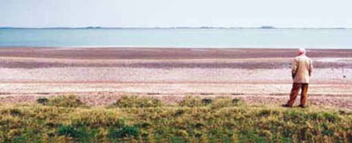
Imagine you are standing on the shore looking south out across the mouth of the Blackwater estuary (viewpoint in Figure 1). What do you see? Perhaps, at first, you take in the general scene, the setting. In front is the broad sweep of the river, which stretches from far upstream to where it first reaches the tide at Maldon and merges with the North Sea. Beyond, on the opposite shore, is the low-lying Dengie peninsula (Figure 2). Around you are the beach, saltmarsh and clay that make up the landscape surrounding the estuary. And above is the vast East Anglian sky, its importance in the scene emphasized by the flat country and sea all around (Figure 2). Here then, we have the three fundamental elements – using the term ‘element’ in the traditional sense of earth, water and air – the components that comprise the natural surroundings or environment, the biosphere (that part of the Earth capable of supporting life).
Click here [Tip: hold Ctrl and click a link to open it in a new tab. (Hide tip)] to view, 'The Blackwater estuary, on the east coast of England, adapted from the Blackwater Estuary Management Plan'.
Click here to view, 'The Blackwater estuary in the late eighteenth century: a map of the County of Essex from an actual survey by John Chapman and Peter Andre, 1777. The illustration has been compiled from eighteenth-century maps in the Essex Record Office'.
Though the elements may be viewed as separate, they are also interlinked through various social and natural processes. Water, for example, which is present not only in the estuary but also on and in the land and as water vapour and droplets in the atmosphere, does not just stay in any one of these three elements but can also move between them.
Box 1: The hydrological cycle
Water in the estuary can transfer to the atmosphere by evaporation from the water surface. Water in the atmosphere can fall on either the land or estuary as precipitation. From the land, rivers can move water to the estuary, and water on land can move through the land as groundwater and also evaporate from the surface or from the pores in leaves of vegetation to the atmosphere (a process called transpiration). This cyclic movement of water is called the hydrological cycle, or water cycle.
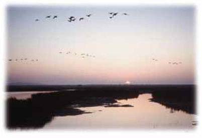
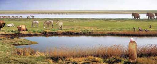
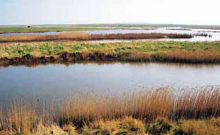
The scene before us is not static; it is one of ceaseless movement, not all of it evident to the human eye. There is the changing weather, sometimes creating spectacular storms that alter the shape of the coastline. There is the ebb and flow of the tides, revealing, at low tide, the gravel and muds of the foreshore. There is also the movement of life: the sea teems with fish and other sea creatures, including the oysters that are famous from this part of the world. The mudflats, too, support abundant life, and many of the species found here occur only in estuaries. It has been calculated that one square metre of mud can hold 1,200 worms, while 15,000 snails (Hydrobia ulvae) can graze on its surface. The saltmarsh forms a coastal ecosystem here with a rich variety of ecosystem salt-tolerant plants (Figure 4). Above, there is the movement of flocks of birds along this important migratory highway (the so-called Eastern Atlantic Flyway).
Box 2: Ecosystems
The term ecosystem was first coined by Arthur Tansley (1935) to describe the interdependent groupings of plants, animals and other living organisms as well as inanimate components (such as water, soil minerals, etc.). All of these things use energy and process materials to produce the communities and landscapes that we see in the world around us. In ecology, the term has become associated with a particular approach to the study of the interactions among living organisms, an approach that concentrates on energy and material exchanges. However, it is also used more colloquially to refer to any area or grouping of organisms that can be regarded as functionally interdependent. An ecosystem in this sense can be of any size, from an isolated clump of mossy vegetation on a rock, to the whole thin layer around the world in which life occurs, the biosphere.
The estuary is never the same. It is always evolving, changing and recomposing. The environment is dynamic. It is a composition of rhythmic processes, of living movement and, from time to time, of sudden change. This feature of changing environments is the first major theme we shall be using in this course and the series as a whole to help you approach your studies. We shall return to this theme in terms of the estuary in a moment.
What other features compose the present scene? Across the estuary, near the tip of the Dengie peninsula, we can see the modest outline of the seventh-century St. Peter's Chapel. The Chapel is near the site of a Roman fort, testimony to the long period of human habitation in the area. About two miles to the west is the bulk of Bradwell nuclear power station, a twentieth-century edifice that provided electricity for 40 years (until 2002) and that will pose the risk of radioactivity leaking into the surrounding area for decades to come. On the water are the local fishing vessels, and in summer a myriad of boats and windsurfers are evidence of the recreational activities in the area. The beach huts fronting the sea indicate a seasonal holiday role. High above there are planes following the flight paths to London Heathrow and Stansted airports. Around the estuary the main occupation is farming, mainly arable (for this is in the cereal-growing east of the country) but also grazing, especially on the low-lying areas reclaimed from the marshes over the centuries. There are also the villages and small towns such as Maldon, Tollesbury and West Mersea together with smaller villages, with all the associated infrastructure of roads, housing, services and sewerage that make up the built environment.
These activities and buildings reflect the different ways in which the environment might be valued by humans. The estuary provides resources that are fished and farmed. It also provides a means of dealing with wastes and pollution: after treatment, sewage is discharged into the estuary. Some radioactive wastes from Bradwell nuclear power station are either stored on site or emitted to sea or air, and other wastes and some toxic materials are disposed of to landfills. The estuary is also an artery giving channels for movement, for the transport of goods and people. Beyond these uses the estuary possesses recreational values for its resident and visiting human populations. These are all insrumental ways of valuing the environment: as a resource or use that is a means to an end. There may also be non-instrumental in values, where environments are valued as ends in themselves, for their beauty, their rarity or their cultural qualities. It is worth noting that environments can be valued for a variety of reasons. For example, the Blackwater is regarded as ‘one of the most important habitats for wildlife in the UK’ (Blackwater Estuary Management Plan in Maldon D.C. and Colchester B.C. 1996, p.1) and of international significance for the coastal ecology of mudflats and saltmarshes. (A habitat is the physical and biological environment in which an organism lives.) The Blackwater's biological diversity has instrumental value as a resource for both humans and non-humans but it also has non-instrumental value in that it is conserved for its own sake. We shall return to the concept of biological diversity later in this course. For the present we shall note that biological diversity is more usually referred to as biodiversity (in its most basic sense, biodiversity is measured by the number and variety of species in an area).
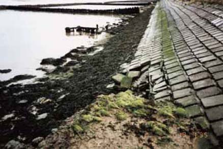
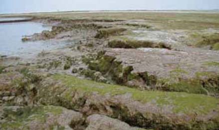
The values placed on the environment may give rise to contest, the second major theme of this course. This theme can help us understand why environmental questions are so pressing. Contests over values may result in conflicts between interests. Within the Blackwater estuary there are many different human interests each of which puts its own particular value on the environment: fishermen and farmers will value the environment as a source of livelihood; industrialists will value its capacity for absorbing pollutants or waste; developers will focus on the market value of the location; wildfowlers prize its potential for sport; birdwatchers or ramblers will value the environment for its own sake, as an end in itself. These differing values often result in conflict between economic and non-economic interests. For example, around the Blackwater estuary the economic value of land for farming has led to the building of sea defences, the draining of saltmarshes and erosion of the marshes on the seaward side (Figure 5). This creates conflict between those interested in economic development (farming) and those interested in conservation (of an important habitat). The estuary provides many other examples of contested values leading to conflicts between interests, for example: conflict over fishing rights; conflict over the public's right of access to the shore; and conflict over proposals for urban or industrial development. In deciding how they value the environment and then pursuing their interests, different groups will not only come into conflict with each other but may have profound effects on non-human species and habitats.
Each interest group will have access to various forms of political power, which they can use to promote their interests. For example, industrialists and developers have economic resources in the form of investment capital and employment; those with conservation interests are able to use the power of influence through the media or the support of local and national groups to exert pressure on decision makers. We shall develop these points later in this unit. For the moment we simply wish to note that studying environments can also be associated with the idea of contest and conflict.
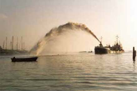
Returning to our viewpoint over the estuary, what other features are evident? Everywhere we can see signs of the effort to protect land from the incursion of the sea. Out to sea there is both dredging of channels and recharging of the foreshore with sand and gravel dredged from elsewhere (Figure 6). The aim is to create barriers to the erosive power of the waves on the shoreline. All around the estuary are earthen sea walls, often dating back to the Middle Ages, enabling grazing and later arable land to be reclaimed from the saltmarsh. In some places, especially close to human settlements, the walls have been reinforced (Figure 7). Elsewhere, in a few places walls have been deliberately breached to enable the recreation of saltmarsh (see Figure 20). Saltmarsh dissipates the energy of waves and thereby provides a form of natural defence against the sea. On a coast along which sea levels are rising and that, from time to time, experiences destructive winds and tides, protection by reinforcing walls is only afforded to urban settlements and valuable structures, such as Bradwell nuclear power station. Elsewhere, the effort to resist the sea is regarded as both too costly and, in the long run, futile. The sea level rise predicted as a result of climatic change merely reinforces the need to provide ‘softer’ forms of protection (such as saltmarsh rather than sea walls) in the hope that creation of new marshlands will compensate for those that are lost through erosion.