
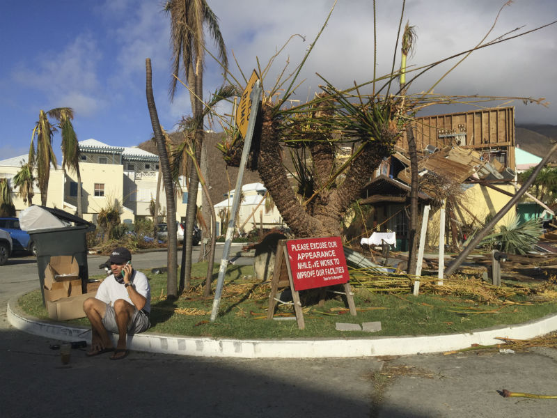
 A man sits next to sign in the marina of Nanny Cay on the British Virgin Island of Tortola, which suffered widespread damage and destruction when Hurricane Irma passed over on 6 September 2017
The post-disaster environment poses immense challenges for crisis response teams tasked with assessing the extent of the damage as quickly as possible, often over thousands of square miles. These teams need a sound and reliable understanding of the situation on the ground, to quickly and safely provide the right help to the people affected.
Citizen scientists from around the world can play a key role in delivering this information to emergency responders on the ground. In the wake of hurricanes Irma and Maria, which swept across the Caribbean during September 2017, an ongoing collaboration between the Zooniverse (an online citizen science platform), the University of Oxford, and NGO Rescue Global, has enlisted thousands of volunteers worldwide to analyse satellite-based information.
The end result is a series of maps that highlight affected areas, providing a robust source of information which helps Rescue Global and the disaster relief community to generate more detailed mapping, and conduct needs assessments, aid deliveries and evacuations on the ground.
Rapid response
When Rescue Global began their Hurricane Irma response operation in early September, the Planetary Response Network, a collaboration between the Zooniverse and Oxford University, was activated quickly and began sourcing satellite images of the disaster-affected areas from data providers Planet, Digital Globe, NASA and ESA.
Next, they issued a shout-out to their existing network of past and present volunteers. A call to action was also distributed by Rescue Global together with the University of Oxford, who were able to rally a large and diverse audience through their social media channels. The initial campaign was so successful that the first set of data was classified in just two hours.
The volunteers analyse a series of “before” and “after” satellite images of the islands damaged by the hurricanes, to identify a number of pre-selected features. These include damaged buildings, areas of flooding, blocked roads, rubbish heaps and new, temporary settlements that may indicate displaced or homeless populations.
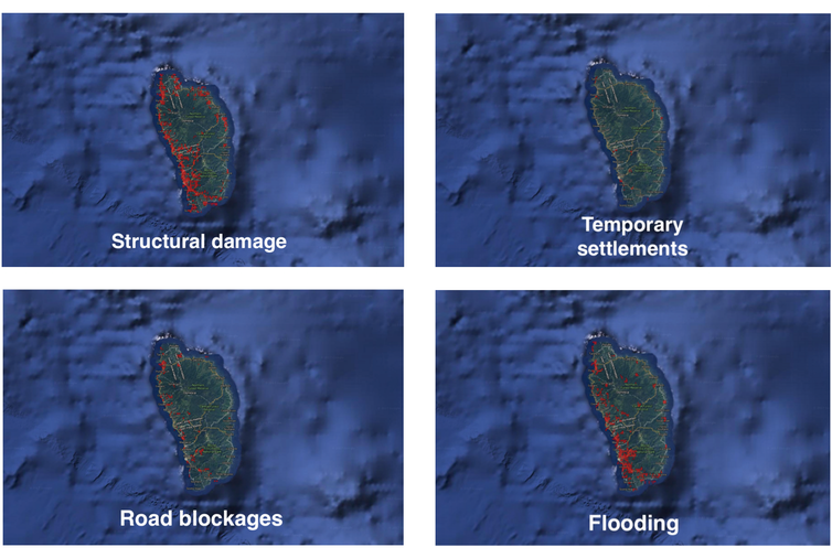 Citizen scientists identify damaged areas in Dominica, following Hurricane Maria
This process happened in real time during the relief operation. New satellite image sets were being released regularly. Depending on the changing response priorities, the Planetary Response Network team could select which sets required urgent analysis, immediately load them onto the Zooniverse platform and launch a fresh call for volunteers.
A joint effort
After each round of analysis is complete, the Machine Learning Research Group at Oxford runs the results through machine learning algorithms. These algorithms can quickly resolve inconsistent responses, bring all the data together and integrate information derived from other crowdsourced mapping sources, such as the Humanitarian Open Street Map and Tomnod.
This approach increases the reliability of the information gathered and generates high quality intelligence that is accurate enough to inform targeted relief efforts. It allows the team to build impact “heat maps”, which highlight areas where features such as flooding and damaged buildings have been consistently identified by the crowd.
These maps enable Rescue Global to better understand the situation on the ground. This is crucial when it comes to drawing up evidence-based plans for critical needs assessments, extensive aerial and ground reconnaissance missions, the successful delivery of aid and satellite communications and for conducting medical evacuations.
This information helps to keep response teams safe, while enabling them to reach areas in urgent need of assistance. The maps are shared widely among the disaster response community, forming part of a suite of intelligence and assessment material from various sources working on the response.
A better future
Over a month has now passed since Rescue Global deployed to the Caribbean, and the Planetary Response Network began mapping the region. By the time Hurricane Maria made landfall in Dominica on September 18, Zooniverse volunteers had classified nine different image sets from all over the Caribbean, as well as additional images of the Turks and Caicos Islands, the US and British Virgin Islands, Antigua and Barbuda.
Over the course of the last three and a half weeks, the time volunteers have spent classifying features has amounted to roughly eight months’ worth of continuous human effort. To put that into perspective; if you hired one person full-time to complete that amount of work, it would take them almost three years.
These tools have been refined over several years, having been used previously to assist Rescue Global in its response to the 2015 Nepal and 2016 Ecuador earthquakes. Now, the platform is being made more adaptable, so it can cope with multiple sudden-onset hazards.
Its flexibility is also being enhanced, so that it’s better able to forecast damage before it even occurs. For example, before post-Maria satellite images were even released, the pre-Irma and Maria images were processed and the machine learning folded in building information from Open Street Maps. In a matter of hours, the network produced maps of the projected damage to aid preemptive response planning.
![]() Reducing risk, building resilience and responding more effectively to disasters all require forward planning. And now, as evidence-based decision making is becoming ever more important for humanitarians, this new technology has the potential to shape a better future for disaster management.
Reducing risk, building resilience and responding more effectively to disasters all require forward planning. And now, as evidence-based decision making is becoming ever more important for humanitarians, this new technology has the potential to shape a better future for disaster management.
This article was originally published on The Conversation. Read the original article.
Rate and Review
Rate this video
Review this video
Log into OpenLearn to leave reviews and join in the conversation.
Video reviews