Lower Mesopotamia and Upper Mesopotamia
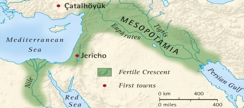
Mesopotamia is an alluvial valley surrounded by the Tigris and Euphrates rivers, which run almost parallel. Both rivers are born in the mountainous regions of Armenia, from where they flew to the Mesopotamian plains, and then follow two almost parallel routes in the northwest-southeast direction, flowing into the Persian Gulf.
Tigris and Euphrates have made Mesopotamia an extremely the fertile region, surrounded, however, by much poorer areas. To the north and successively from east to west, Mesopotamia has borders with the mountainous regions of Elam, the Zagros mountains and Armenia in the south bordering the Arabian desert.
All these regions were traditionally inhabited by nomadic, semi-wild peoples, who never ceased to aspire, during antiquity, to the greater wealth of sedentary, civilized peoples, established near the two great rivers.
Only through its border at the western end does Mesopotamia come into contact with another relatively rich region, namely Syria, and through it Palestine, both forming what is called the Mediterranean Levant.
On the coast of this region, the Phoenician ports are located, a destination since the most remote antiquity, of the caravan routes, coming from Mesopotamia.
Mesopotamia contacted commercially, by sea, through the Phoenician ports with other regions of the Mediterranean particularly with Egypt, Cyprus, Crete and the Aegean.
Mesopotamia and the Mediterranean Levant, form a set of rich lands, with the configuration of an arch, constituting a more or less narrow strip of land from East to West, passing through the North, surrounded by much poorer regions. It is called the Fertile Crescent.

The Fertile Crescent constituted the totality of the world known to sedentary inhabitants of Mesopotamia. Surrounded by mountains and deserts populated by hostile peoples, the Mesopotamians had a characteristically self-centred view, knowing no more than the Sumer, Akkad, Subaru and Amurru.
In reality, Sumeria is the southernmost region of Mesopotamia, adjacent to the shores of the Persian Gulf.
Akkad is the region that is immediate to the north of Sumeria, reaching approximately the present area Baghdad which is the place where the Tigris and Euphrates courses are closest to each other. Sumer and Akkad together form Lower Mesopotamia, a region that in later times will have the historic name of Babylon.
Ascending the Tigris and Euphrates courses, we arrive at Upper Mesopotamia, an extensive region that was named Subaru and later Assyria, by extension of the name of the small region where the Assyrians originated and that was on the banks of the Tiger, next to the base of the Zagros hills.
If we continue through Upper Mesopotamia, the courses of the Tigris and the Euphrates will gradually move away. The course of the Tigris, which is to the north of the Euphrates, goes directly to the North where it has its source, while the one of the Euphrates, goes to the west entering Syria, describing a large arch to the west before, for, in turn, head north and east, going to be born near Lake Van.
The Euphrates thus passes a relatively short distance from the Mediterranean coast, fertilizing, together with the Orontes, the Sirian plains.
The Orontes is a small river that runs in a north-south direction, particularly parallel to the coast of the Mediterranean Sea, before flowing into it, not far from the site of the future Antioch.
The Mesopotamians called this whole region Amurru, which, as we have seen, extends to the south through Palestine, which in turn is bathed by the Jordan River. This river is also parallel to the Mediterranean coast as the Orontes has, on the contrary, a course in the north-south direction, going into the Dead Sea.