

1.9 What is plate tectonics? Continental drift and sea floor spreading - part 1
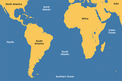
Have you ever looked at a map of the Atlantic Ocean and thought that the coasts of Africa and South America look like they could fit together like a jigsaw?
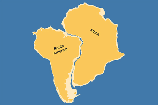
You wouldn’t be the first. In fact, the similarity was written about by a Königsberg Professor of Theology, Theodor Christoph Lilienthal, as early as 1756. Later, in 1845, the explorer Alexander von Humboldt wrote about the similarity of both the shape of the coastlines and the rocks on either side of the Atlantic.
The reason for the similarity is because they did fit together once, as depicted below.
So what makes the continents move about? The other side to continental drift is sea floor spreading.
Figure 1.12 above suggests that the Atlantic Ocean (both the North and South parts) hasn’t always been there, so is that true?
As you learned earlier this week, there are a few different ways of finding the ages of different rocks. When applied to rocks all over the Earth, one thing stands out in particular – that the rocks at the bottom of the oceans are usually younger than the continents. And in this case, even the oldest rocks that make up the bottom of the Atlantic are much younger than most of the rocks that make up the continents on either side. This makes sense if the continents were once there, but the ocean now in between them wasn’t.
Another clue was found during the late 1950s and early 1960s. During this time, a lot of money was being spent on research and surveying of the sea floor – in part because of the amount of submarine activity during the Cold War. What was discovered was a series of strange, symmetrical disturbances in the magnetic field within the rocks on the sea floor.
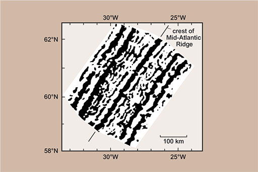
So, what caused the stripes? The rocks on the sea floor are igneous – as you learned before, this means that they are formed when liquid magma cools and solidifies into rock. As that happens, parts of certain minerals in the rocks align with the Earth’s magnetic field like little compass needles – we call this magnetisation, because they form very weak magnets. Geoscientists can measure that magnetisation using sensitive instruments called magnetometers, and that’s what’s shown as the stripes in the picture.
The other piece of the story is that the Earth’s magnetic field hasn’t always been the way round that it is today. If you were standing on the Earth 800,000 years ago your compass wouldn’t point to the North Pole, but to the South Pole! If you went back further to 1 million years ago, it would be pointing north again, and further still to 4 million years ago it would be pointing south. These switches in the Earth’s magnetic field are called ‘magnetic reversals’ and they happen every million years or so. This is actually another way that rocks can be dated – by looking for the evidence of these reversals.