

2 Mileage charts
Can you think of a time when it is useful to be able to understand and work out distances between places? It’s useful to know how far apart places are if you’re planning a trip. If your job involves lots of travelling from place to place, you need to calculate how much mileage you do so that you can reclaim how much money you’ve spent on petrol.
How far is it from your home to the nearest shopping centre?
Your answer is probably something like ‘three miles’ or ‘ten kilometres’. Distances between places are often measured in either miles or kilometres. Road signs in the UK and USA use miles, whereas in Canada and Europe, for example, the road signs are in kilometres. What’s the difference between the two?
Kilometres are a metric measure of distance.
- 1 000 metres (m) = 1 kilometre (km)
Miles are an imperial measure of distance.
- 1 mile = 1 760 yards
One mile is a bit less than two kilometres.
Because most maps and road signs in the UK use miles, in this section you’ll work with miles.
If you have to plan a trip, it’s useful to look at a mileage chart. This shows you how far it is between places:
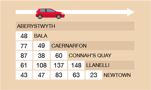
To read the chart, find where you want to start from and where you want to go. Then follow the rows and columns until they meet.
Case study _unit3.2.1 Example: Finding the distance
Now try the following activity.
Activity _unit3.2.1 Activity 8: Reading a mileage chart
Now use the mileage chart in Figure 10 to answer the following questions. Remember to check your answers.
- What is the distance from Newtown to Bala?
- The Connah’s Quay Nomads’ next match in the Welsh Premier League is against Newtown. How far will supporters have to travel to watch the football match? (Hint: Don’t forget to calculate the distance for a return journey.)
- Which team’s home ground is the closest in distance to the ground of the Connah’s Quay Nomads?
Answer
- The distance between Newtown and Bala is 47 miles.
- The distance from Connah’s Quay to Newtown is 63 miles, so the Nomads’ supporters would have to travel 126 miles (63 × 2).
- To calculate this, you must check the places to the right of Connah’s Quay in the table (Llanelli, 148 miles; Newtown, 63 miles) and the towns to the left of Connah’s Quay in the table (Caernarfon, 60 miles; Bala, 38 miles; Aberystwyth, 87 miles). So the home ground of Bala Town would be the closest to the Connah’s Quay Nomads.
Case study _unit3.2.2 Example: A European journey
Look at Figure 12. It has a different layout to the previous mileage chart.
Some European cities are listed down the left hand-side of the chart, and a series of ports are listed along the top.
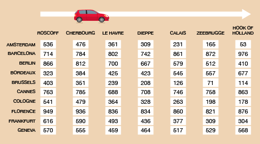
Use the mileage chart to find the distance between Florence and Calais.
Method
To answer this, you need to find the row for Florence and go along it until it meets the column for Calais.
The distance between Florence and Calais is 860 miles.
Now try the following activity.
Activity _unit3.2.2 Activity 9: A European journey
Now answer the following questions using Figure 12.
- Which port is closest to Florence?
- How far is it from Cologne to Dieppe?
- If you were staying in in Amsterdam, which would be your closest port?
Answer
- The closest to Florence is Zeebrugge (821 miles).
- The distance between Cologne and Dieppe is 328 miles.
- If you were staying in Amsterdam, the closest port would be Hook of Holland (53 miles).