

7 Maps
A map gives you a detailed drawing of a place. They are used to find out how to get from one place to another. They use a scale that lets you calculate the actual distance from one place to the other.
If you look in a holiday brochure you will see lots of maps. They are often used to show how a resort is laid out. They show where a few important places are, such as local shops, hotels, the beach, swimming pools and restaurants.
It is important to understand how to read a map so that you do not end up too far from the places you want to be near – or too close to the places you want to avoid!
Example: Holiday map
Here is a typical example of a map you find in a holiday brochure.
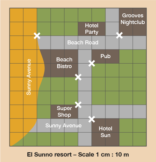
How far apart is everything on this map? Each square measures 1 cm on the map.
Method
As with scale drawings, the thing you need to know before you can understand the map is the scale and how to read it.
This means that for every 1 cm square on the map there are 10 metres (10 m) in real life.
Using the scale, you can interpret the data on the map and work out how far different places are from one another.
To do this you need to measure the distances on the map and then multiply the distances in centimetres by 10 to get the actual distance in metres.
So on this map the Grooves Nightclub is 1 cm from Hotel Party. In real life that’s 10 m – not very far at all. Knowing this could affect whether you choose to stay at Hotel Party, depending on whether you like nightclubs or not.
Now try the following activity. Remember to check your answers once you have completed the questions.
Activity 13: Using a map to find distances
Let’s stay with the map of the holiday resort.
Hint: The entrances to the buildings are marked with crosses on the map. You need to measure from these crosses.
- What is the distance in real life between the pub and Hotel Sun in metres?
- How far is it in real life from the Super Shop to the Beach Bistro in metres?
- What is the distance in real life from Grooves Nightclub to the beach in metres?
Now try these:
- A map has a scale of 1 cm to 5 km. On the map, the distance between two towns measures 6 cm. What is the actual distance between the two towns? Remember to show the units in your answer.
- A scale is given as 1 cm to 2 km. When measured on a map, the distance from the college to the bus station is 4.5 cm. What is the actual distance?
Answer
-
The distance on the map between the pub and Hotel Sun is 4 cm, and the scale is 1 cm : 10 m. Because you need to work out the real measurement, you need to multiply the map measurement by 10:
- 4 cm × 10 = 40
The actual distance in real life between the pub and Hotel Sun is 40 m.
- The distance on the map is 2 cm. Using the same calculation, the actual distance in real life between the Super Shop and the Beach Bistro is 20 m.
- The distance on the map is 6 cm. Using the same calculation, the actual distance in real life between Grooves nightclub and the beach is 60 m.
- The scale is 1 cm to 5 km. The distance on the map is 6 cm, so multiply 6 × 5 km to give an answer of 30 km.
- The scale is 1 cm to 2 km. The distance on the map is 4.5 cm, so multiply 4.5 × 2 km to give an answer of 9 km.
Summary
In this section you have learned how to use maps.