
The archipelago is a chain of islands that lie off the northern tip of the Indonesian Island of Sulawesi in the Celebes Sea. Zoom in, out and around using this map:
 The expedition route started from just south of Manado, situated at the northern tip of the Sulawesi mainland, and travelled north through to the capital of Pulau Sangihe (Sangihe Island), Tahuna.
In 3.5 weeks the team travelled some 300 nautical miles (there and back), visited the 6 main island groups and more than 20 villages.
The team reflected:
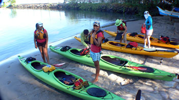
Our kayaks created connections through their initial similarity to local canoes, and we were instantly welcomed on that basis. The fact that we were women and approached the coasts by sea kayak enabled us to access areas that were frequently overlooked because they are not accessible by larger craft, and enabled us to engage differently with our respondents.
The men were fascinated by the boats, whilst the women were interested in us. We were warmly welcomed into their lives, and respondents were immediately open to our questions about coastal lives and livelihoods. The kayaks did useful ‘work’ in opening up new ways of doing research.
Some islands were protected by reefs and had mangrove or sandy beaches; others, especially those with active volcanoes, plunged straight into the sea, with depths just off shore of hundreds of metres.
The size of the village communities in terms of population ranged from around 300 to 6000, but with little difference in physical size. Beaches suitable for camping were remarkably few and far between.
The coral reefs were in better condition than expected, but there were large amounts of rubbish, mostly plastic bottles.
Activity 1: Get to know the area
Use the map above to enter Manado and Pulau Sangihe, Tahuna as points A and B. If you'd like to view a larger map, visit Google Maps in a separate tab and search for the locations.
- Zoom in and find out the name of the sea to the right of the archipelago.
- Zoom out and locate the following countries: Malaysia, East Timor, Papua New Guinea, the Philippines, Solomon Islands; and identify some of the other islands that make up Indonesia.
Visit the Hugging the Coast website and answer the following questions. - What is meant by describing the Coral Triangle as the ‘Amazon of the seas?’
- The Coral Triangle Initiative (CTI) focuses on coral reefs, fisheries and food security. Why?
This Learning Journey is part of the Creative Climate project on OpenLearn. Go to the introduction or move to the next part of the journey.
Rate and Review
Rate this activity
Review this activity
Log into OpenLearn to leave reviews and join in the conversation.
Activity reviews