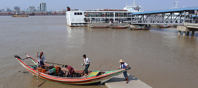
1.4.1 River basins
A river basin is the area of land that is drained by a river and its tributaries. There are eight major river basins in Myanmar.
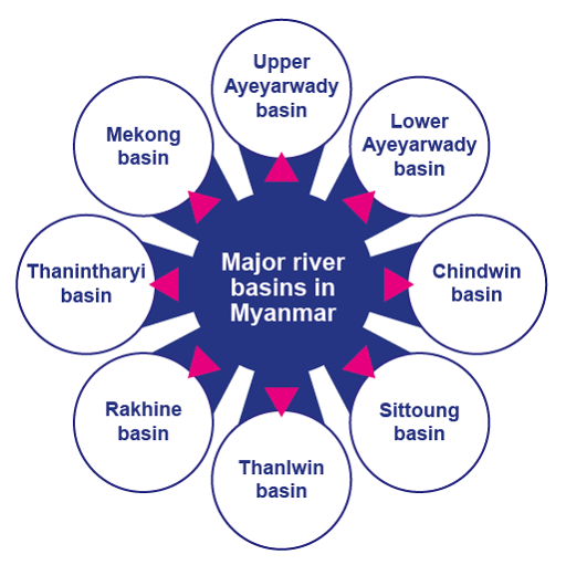
The Ayeyarwady and the Thanlwin basins are the largest. The river basin characteristics vary considerably due to the climatic conditions and physical features in Myanmar. The Ayeyarwady basin covers the central plains and the southern delta area that represent the most important croplands of the country and are the most intensively populated areas in Myanmar.
In the central valley in the Ayeyarwady basin, which is the Dry Zone of the country, irrigation is essential for cultivation. The Thanlwin River provides very little riverine flat land for cropping, but has large hydropower potential.
The main water resources for the Central Dry Zone in Myanmar are influenced by the climate and seasonal rainfall. Mean annual rainfall in the Dry Zone ranges from 500 to 1,000 mm. This is low compared to the 2,000–5,000 mm range received by the rest of the country.
Mean, median, mode and range
Mean, median, and mode are three kinds of "averages".
The "mean" is the "average" you are probably used to, where you add up all the numbers and then divide by the number of values.
The "median" is the "middle" value in a list of numbers. To find the median you have to write out the numbers in numerical order from the smallest to the largest. The median is the middle number, and where you have an even number of total numbers, you take the two medians if they are different, add them together and divide by two (so effectively you find the mean of the two medians).
The "mode" is the value that occurs most often. If no number in a list is repeated, then there is no mode for the list.
The "range" of a list of numbers is just the difference between the largest and smallest values.
Question 9
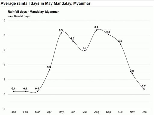
Above are the average monthly daily rainfall records for Mandalay.
The Ayeyewady River and its tributaries dominate surface water resources in the Central Dry Zone. The Chindwin River is the major tributary of the Ayeyewady River; other significant tributaries are the Mu, Shweli and Myitnge. These rivers provide water for irrigation and, in some places, recession agriculture, where farmers capitalize on natural flows and sediments to irrigate and fertilize crops on floodplains. A floodplain is an area of flat land next to a river, formed mainly of river sediments and subject to flooding.
However, some of the river courses are deeply incised into the landscape, so water for irrigation can only be obtained by pumping. Given the seasonal nature of rainfall, communities need to retain and store rainwater and runoff received during the wet season for use in the dry season.
There is a widespread view that the groundwater reserves of the Central Dry Zone are vast and largely unexploited. Groundwater quality would appear to be fit for general purposes over large parts of the Dry Zone. It is generally of low to moderate salinity (typically 1,000 to 2,000 μScm), although brackish to saline groundwater is found, in particular, in the western and delta areas.
Water and soil salinity
It is not only water that takes up salt becoming brackish or saline. Soil does too. Salinity in water and soil is measured by passing an electric current between two electrodes of a salinity meter in a sample of soil or water. The electrical conductivity or EC of the sample is influenced by the concentration and composition of dissolved salts. Salts increase the ability of a solution to conduct an electrical current, so a high EC value indicates a high salinity level.
The level of salinity is measured in a number of ways, but the most common are in EC units, or μScm (micro Siemens per centimetre). These have equivalent values, so 1,000 to 2,000 μScm is the same as 1,000 to 2,000EC.
In addition, there are two major natural lakes in Myanmar, which are Indawgyi Lake in Kachin State and Inle Lake in Shan State. Indawgyi Lake is one of the largest inland lakes in Southeast Asia, measuring 24 km long and 13 km wide.
Inle Lake is the second largest lake in Myanmar at 22km long and 10 km wide. The watershed area for the lake lies to a large extent to the north and west of the lake. The main business in this region is agriculture with the floating gardens. Both lakes are part of biosphere reserves that includes the lake and the surrounding wetlands and forest.
Biosphere reserve
A biosphere reserve is an ecosystem with plants and animals of unusual scientific and natural interest. It is a label given by UNESCO to help protect the sites. They are sites for testing interdisciplinary approaches to understanding and managing changes and interactions between social and ecological systems, including conflict prevention and management of biodiversity (UNESCO, 2020).
An ecosystem is a biological community of interacting living organisms and their physical environment. The living and physical components are linked together through nutrient cycles and energy flows. Ecosystems can be of any size, but usually they are in particular places. They regulate essential ecological processes and support lives.
1.4 Water Resources in Myanmar