1.5 Managing the availability of water resources in Myanmar
The catchment area of Myanmar’s rivers comprises about 737,800 km². The potential water resource volume is about 1082 km³ for surface water and 495km³ for groundwater (WEPA, 2018). Most of the irrigation reservoirs are sited on the tributaries and streamlets of the main water resources. In the reservoirs and lake areas, deteriorating water quality and excessive sedimentation are the main challenges.
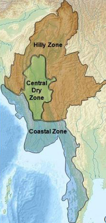
In order to understand the availability of water in Myanmar, the country can be divided into three agro-ecological zones – the coastal zone, the Central Dry Zone, and the hilly zone as shown in Figure 6.
The Coastal Zone
Myanmar has a very long coastline at 2,400km. Along its west coast, it borders the Bay of Bengal and the Andamen Sea. This makes it subject to frequent tropical storms and cyclones during October to December with a secondary peak from April to May. These cyclones are making landfall more regularly and with increasing severity as shown by the devastation of Cyclone Nargis in May 2008. Myanmar’s coastline is also very vulnerable to rising sea levels as a result of climate change.
The extension of agriculture and aquaculture in the coastal regions has led to the cutting down of mangroves which are invaluable for the marine ecosystem and coastal protection. Aquaculture is the breeding, rearing, and harvesting of fish, shellfish, algae, and other organisms in all types of water environments. It is basically farming in water, rather than on land. There are two main types of aquaculture – marine and freshwater. In the Ayeyarwady delta alone only 14% (relative to 1925) of the original mangrove forests survive (Government of Myanmar, 2014). The main challenge here is to build dykes and drainage canals in these low-lying reclaimed coastal areas, a process known as poldering.
The Central Dry Zone
The agricultural productivity of this region is crucial for the country. The Central Dry Zone benefits least from the Southwest Monsoon, due to the high mountains surrounding the area, but occupies two-thirds of the agricultural land and has higher temperatures than elsewhere in the country. The climate of the Dry Zone can be divided into two periods – the wet season and the dry season.
- The wet season coincides with the Southwest monsoon and lasts from May to October.
- The dry season is divided into winter (November to February) and summer (March to April).
The Dry Zone also typically experiences a brief dry spell during the wet season also in June/July. There is a scarcity of water in the Central Dry Zone. Groundwater is crucial across the Central Dry Zone supplying water for irrigation, although it is used inefficiently with much of it is lost to the air by evaporation before it can be taken up by crops. Existing irrigation systems are also in need of upgrading and improved drainage could reduce widespread salination of the land.
Climate change is having severe impacts on agricultural production in this region, with changes in the precipitation patterns and rising temperatures increasing the likelihood of crop failures in the short-run and production declines in the long-run.
The Hilly Zone
The higher elevations of the highlands are predisposed to heavy snowfall, especially in the North. The Northern regions of Myanmar are the coolest, with average temperatures of 21 °C (70 °F). Coastal and delta regions have an average maximum temperature of 32 °C (89.6 °F).
In the mountainous area, unsustainable agriculture practices of slash and burn and deforestation are eroding slopes increasing flooding, building up sediment, impacting water supply and inland water navigability, and downstream, silting the delta area (Government of Myanmar, 2014).
All these issues suggest the urgent need for an integrated approach to water resource management to halt degradation, maximise yields and improve farmer livelihoods. You will study integrated water resource management in Myanmar in Chapter 4 of the course.
1.4.1 River basins