2 Mileage charts
Can you think of a time when it is useful to be able to understand and work out distances between places? It’s useful to know how far apart places are if you’re planning a trip. If your job involves lots of travelling from place to place, you need to calculate how much mileage you do so that you can reclaim how much money you’ve spent on petrol.
How far is it from your home to the nearest shopping centre?
Your answer is probably something like ‘three miles’ or ‘ten kilometres’. Distances between places are often measured in either miles or kilometres. Road signs in the UK and USA use miles, whereas in Canada and Europe, for example, the road signs are in kilometres. What’s the difference between the two?
Kilometres are a metric measure of distance.
- 1,000 metres (m) = 1 kilometre (km)
Miles are an imperial measure of distance.
- 1 mile = 1,760 yards
One mile is a bit less than two kilometres.
Because most maps and road signs in the UK use miles, in this section you’ll work with miles.
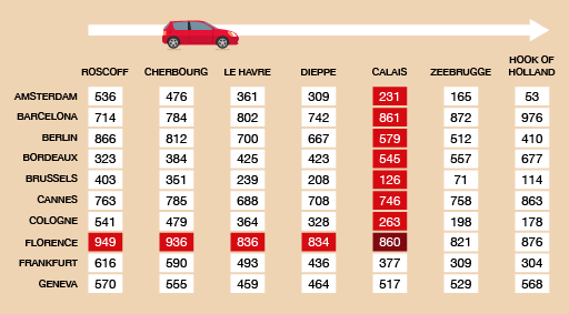
If you have to plan a trip, it’s useful to look at a mileage chart. This shows you how far it is between places:
To read the chart, find where you want to start from and where you want to go. Then follow the rows and columns until they meet.
Now try the following activity. Remember to check your answers once you have completed the questions.
Activity 4: A European tour
You want to go on holiday to Florence, crossing the Channel and then driving. You’ll need to refer to this mileage chart to answer the questions in this activity.
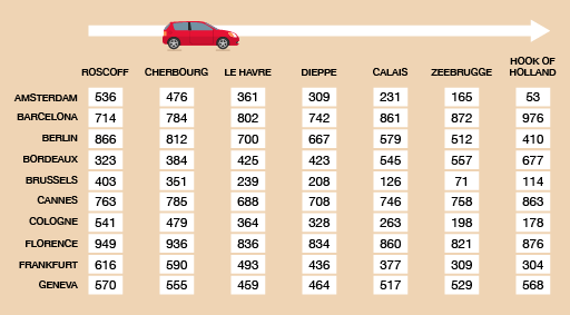
- How far is it to Florence from Calais?
- A series of ports are listed at the top of the table. Which port is closest to Florence?
You will come back via Cologne in Germany.
- How far is it from Cologne to the port you chose?
- How far is it from Cologne to Calais?
- Which would be the best port to use?
Answer
- You need to find the row for Florence and go along it until it meets the column for Calais.
The distance between Florence and Calais is 860 miles.
- You need to look along the row for Florence and find the shortest distance, then see which port is named at the top of the column. The shortest distance is 821 miles, from Zeebrugge.
- You need to look along the Cologne row until you get to the Zeebrugge column. The distance in 198 miles.
- Check the distance from Calais to Cologne: 263 miles.
- Zeebrugge is the best port to use because it’s closest to both Cologne and Florence.