

1.2.6 Navigating by the stars
Constellations weren’t just for telling stories in the ancient world. Because they are easily recognisable patterns, people have used the night sky for navigation when no landmarks were available. Celestial navigation has helped sea captains for centuries, and also aircraft pilots during the early days of aviation.
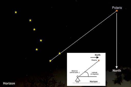
The Plough (or the Big Dipper) is part of Ursa Major, the Great Bear. It can be used to locate the ‘Pole star’ (or ‘Polaris’ or the ‘North star’) in the northern hemisphere. Use the two stars at the end of the Plough, known as the pointers, to indicate a direction. Follow this line for about five times the distance between the two stars, and the next bright star you reach will be the Pole star. Looking at the Pole Star, if you imagine a line vertically down from the Pole Star to the horizon, this is North. East is to the right, and west to the left. South is ‘behind’ you.
The Pole star currently sits in the sky directly over the Earth’s North Pole. Because the Pole star is above the Earth’s axis of rotation, it stays in practically the same place in the sky throughout the night and throughout the year, and as such can be used to help with navigation at night.
Finding your latitude using the Pole star
Once you have determined which direction is North, you can use the Pole Star to determine how far north you are – your latitude. As shown in the inset to the image above, when you face the Pole Star (i.e. are looking north), the angle between the horizon and the Pole Star is equivalent to your latitude. For example, from southern England the Pole star will be about 52 degrees above the horizon, indicating a latitude of 52 degrees north. Polaris will be directly overhead at the North Pole, and on the horizon at the equator.
Finding south using Orion
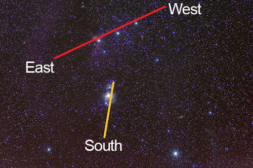
In the northern hemisphere, we can also use the constellation of Orion to help us navigate. The three bright stars that make up the belt run in a line roughly from east to west. The sword that hangs from the belt points towards the south.
Finding south using the Southern Cross
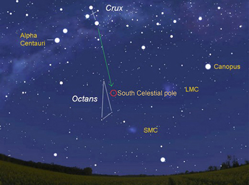
In the southern hemisphere, one of the brightest constellations in the sky is the Southern Cross (or ‘Crux’). This constellation allows navigators to determine which direction is south.
Next, you will find out how to discover your longitude.