

2.4 Surface features revealed by Cassini–Huygens
Explore this image gallery to discover what the Cassini–Huygens mission found out about the surface of Titan on a broader scale.
Figure 13 is about the best that the Cassini orbiter’s selective near-infrared imaging can do. It shows bright and dark areas on the surface. The bright areas are highlands, probably of exposed water-ice (which plays the role of solid bedrock on Titan), whereas the dark areas are low-lying regions made dark by tarry substances (hydrocarbons of high molecular mass) washed out of the atmosphere. The very brightest features are clouds of condensed methane, which occur below the global smog layer and from which methane rainfall may be expected at times.
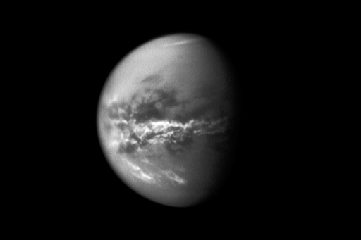
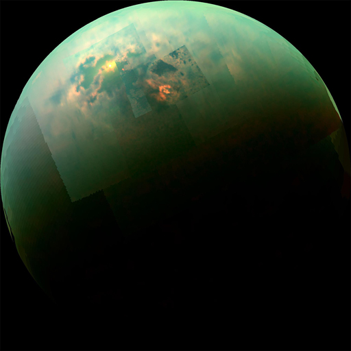
Figure 14 is a near-infrared, colour view mosaic of Cassini images obtained in August 2014. It is of Titan’s far north, and here the darkest areas are large lakes or seas filled by liquid methane and ethane. The bright ‘bathtub-ring’ shores of some of the seas are a consequence of seasonal fall in the liquid level, and are either clean ice yet to be darkened by tarry surface contaminants, or something bright deposited as the liquid evaporated. The yellow spot in the upper left is ‘sun glint’, the reflection of the Sun from the liquid surface. The red-tinted arrowhead-shaped feature near the centre is clouds of condensed methane.
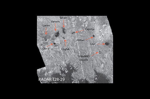
This radar image (Figure 15) shows an area known as Titan’s Lake Country in the moon’s north polar region. Part of a 125 000 km2 lake can be seen in the bottom of the image. Drainage channels can be seen feeding into the lake. Other smaller lakes are annotated (red arrows). These lakes are full of liquid hydrocarbons (methane and ethane).
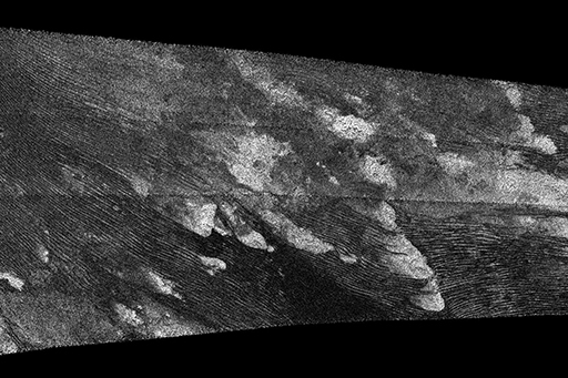
As well as lakes and drainage channels, radar has also imaged dune fields. They stretch across 10 million km2 of Titan’s surface and are constrained to tropical regions 30° north and south of the equator. They consist of organic material that accumulates from the atmosphere and is shaped into dunes by winds. Figure 16 is a 900-km long portion of an image strip. The bright patches are high ground consisting of icy bedrock. The dunes are the curved dark streaks on the low-lying tracts of the icy bedrock.
As you saw in the ‘Descent to Titan’ video, the Huygens lander was able to image the landscape during its descent and after its landing. Figure 17 is images taken at four different altitudes during Huygens’ descent. During descent the orange haziness cleared to reveal valleys, ridges and channels.
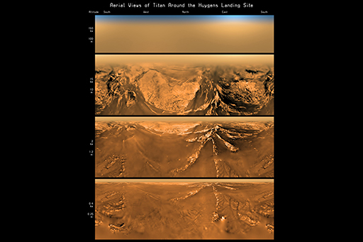
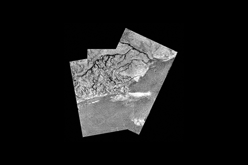
Figure 18 is a mosaic of three images, showing a lighter, higher area of high ground next to a darker, lower area. The high ground has dark channels with smaller tributaries feeding into it and the main channel eventually leads to the darker area. These features are remarkably similar to drainage channels and shorelines seen on Earth. Huygens landed near Titan’s equator and the dark areas here are not occupied by liquid today (unlike the lakes near Titan’s poles) so they are currently dry. The white patches may be low banks of methane cloud.
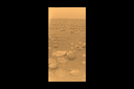
Huygens landed in what may be a dry river bed. Figure 19 is a false-colour image of the landing site, showing larger, rounded pebbles of dirty water-ice, within fine-grained sediment. The roundness of the pebbles suggests they had been transported and subjected to abrasion by liquid and that beneath some of the pebbles the finer sediment was either washed away as the liquid drained or blown away by the wind after the area had become dry. The liquid was almost certainly methane, as the surface temperature is far too cold for liquid water. The Cassini orbiter revealed lakes of liquid hydrocarbons in other locations, suggesting that Titan has a methane cycle analogous to the hydrological cycle on Earth, controlling the distribution of liquid on the surface.
See also: The first global map of Titan’s geomorphology was published in November 2019. You can see it, and read about it at this link [Tip: hold Ctrl and click a link to open it in a new tab. (Hide tip)] .