

3 A global view of Earth history
Figure 3, below, shows how the Earth's continents have drifted across the globe over the past 550 million years. This is a reconstruction of continental configurations of the Earth's landmasses during the Phanerozoic Eon. Note how northern and southern parts of the British Isles (red) were dispersed over two continents/tectonic plates until the end of the Devonian (a–d), and that all the landmasses formed one supercontinent during the Permo-Triassic (f).
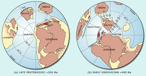
(a) The northern British Isles is located at the passive margin of Laurentia, while the southern British Isles is situated behind the subducting margin of Avalonia, a micro-continent on the edge of Gondwana. Both Laurentia and Avalonia are south of ~40° S and are separated from each other by a spreading ocean (which becomes the Iapetus).
(b) The southern British Isles is still located at the margin of Avalonia, which has drifted southwards to ~60° S. In contrast, Laurentia, carrying the northern British Isles, has started to drift northwards, residing at ~20° S, separated from Gondwana by the Iapetus Ocean (which is now beginning to close).
(c) The Iapetus Ocean has been progressively closing, bringing the micro-continent of Avalonia (including the southern British Isles, ~30° S), closer to Laurentia (including the northern British Isles, ~20° S). At the northern margin of the ocean, subduction is occurring below Laurentia, whereas the southern margin with Avalonia is passive. To the south of Avalonia, the Rheic Ocean is actively spreading.
(d) ‘Zipper-like’ continental collision has been occurring between Laurentia and Avalonia, uniting the British Isles along the Iapetus suture zone (purple line). This collision is known as the Caledonian Orogeny. At this time, the British Isles are at ~20°–25° S, located within the southern desert latitudes.
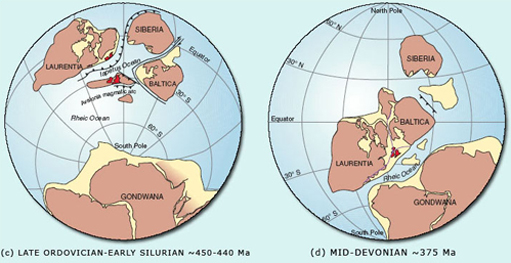
(e) As the Rheic Ocean closes between Laurentia, Eurasia and Gondwana, the Variscan Orogeny starts to affect the southern British Isles. During the Carboniferous, continental drift has carried the British Isles northwards across the equator, into subtropical latitudes.
(f) All of the landmasses have united to form the supercontinent Pangea. To the east, Tethys is actively spreading, while the British Isles continues to drift northwards to 20°–30° N, equivalent to the modern day Sahara latitudes.
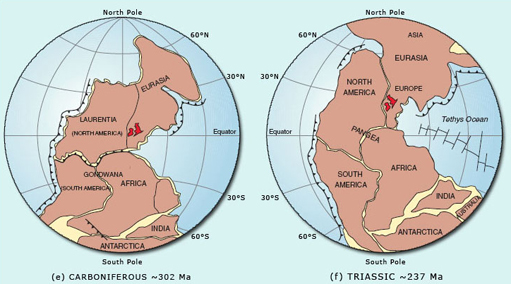
(g) Break-up of Pangea results in Gondwana and Laurasia separating, as the southern Atlantic Ocean starts to rift open. The British Isles continues to drift northwards to ~35°–40° N into more temperate conditions, with lithospheric extension and passive rifting occurring to the east (forming the North Sea) and west (where later the North Atlantic will open).
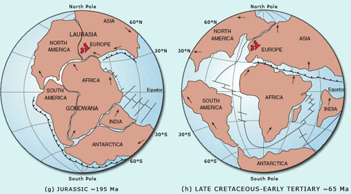
(h) Passive rifting has given way to active rifting to the west of the British Isles, allowing the northern Atlantic Ocean to continue opening in a zipper-like fashion northwards. Active sea-floor spreading is occurring throughout the Atlantic, Indian and Pacific Oceans, whilst Tethys closes, resulting in the eventual collision of Africa, India and Eurasia.
Question 1
Describe in one sentence how the geographical position of the British Isles has varied since the Cambrian.
Answer
Over the last ~550 million years, the British Isles has formed a small portion of a series of different continental masses (being in fact part of two separate continents in the Cambrian), and has slowly drifted northwards to its present latitude.
Until the end of the Silurian and beginning of the Devonian, the northern and southern halves of what is now the British Isles were on different continents, separated by an ocean – the Iapetus (Figure 3a–c). The existence of this ocean, along with the collision between these continents is recorded by the Caledonian Orogenic Belt, which contains rocks formed within and on the flanks of the now vanished Iapetus (Figure 3d). By ~375 Ma (Figure 3d–e), this ocean had closed with the resultant continental collision producing a series of major tectonic structures that can be observed on the Ten Mile Map.
At a later date, the Variscan Orogenic Belt (which is found in the southern British Isles) formed as a result of another period of continental collision, when the Rheic Ocean closed between Laurentia and Gondwana (Figure 3e). This tectonic activity led to the unification of all the globe's main continental landmasses into one supercontinent called Pangea (Figure 3f).
Figure 3g and h shows stages in the break-up of Pangea, which resulted in the formation of new oceans (including the Atlantic), as well as the formation of another extensive orogenic belt when Africa collided with Europe to form the Alps, and India collided with Asia to form the Himalayas. These last two examples illustrate that orogenic episodes in one region can occur at the same time as ocean spreading in another region.
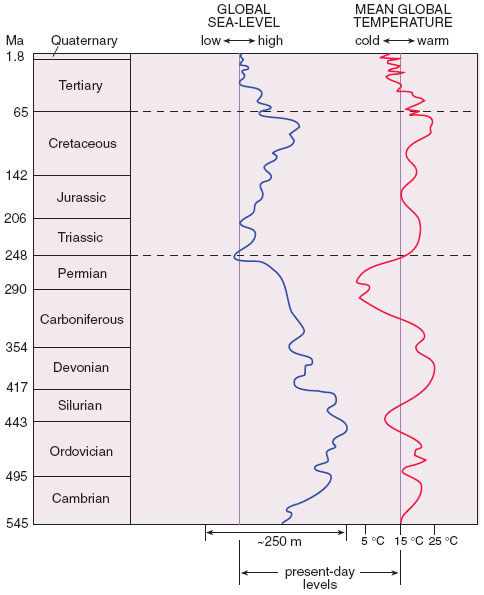
In addition to the continental landmasses moving over time, driven by a variety of plate tectonic processes, geologists can also recognise episodic fluctuations in the relative global sea-level throughout the Phanerozoic (Figure 4). Although a detailed study of the causes of relative sea-level change is beyond the scope of this course, it is important to recognise that these processes do occur. If these processes cause the relative sea-level of the whole globe to change, they are referred to as eustatic sea-level changes, whereas if they have a more local effect and are due to isostatic readjustments (e.g. orogenic movements), they are referred to as epeirogenic sea-level changes. In Figure 4, the relative change in eustatic sea-level (and mean global temperature) is plotted against time, using the present day sea-level as a baseline.
Question 2
Compare the sea-level curve in Figure 4 with the maps in Figure 3 showing the changing assembly of continental masses through time. Briefly describe any correlation between sea-level and the degree of unification of the continental landmasses that you can detect.
Answer
A crude correlation between these factors can be observed, with the sea-level low between 300–200 Ma corresponding to a time when all of the land was together in the supercontinent of Pangea (Figure 3e–f). The sea-level highs before and after this period correspond to times when the continents were drifting apart.
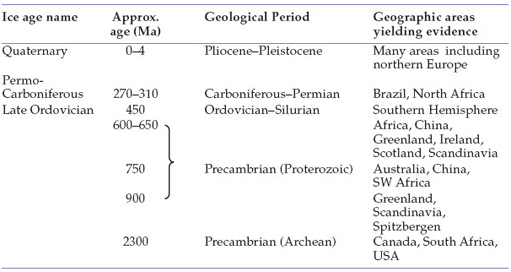
One cause of global changes in sea-level could be the formation of thick continental ice caps reducing the volume of water in the oceans, resulting in a eustatic fall. When this ice melts, the sea-level must rise. Table 1, below, summarises the occurrence of major ice ages over the past 2300 million years.
Question 3
Compare the approximate ages of the ice ages from Table 1 with the global sea-level curve in Figure 4. How well do these data correlate with each other?
Answer
There is a good correlation between the sea-level ‘lows’ and the Quaternary and Permo-Carboniferous ice ages, but global sea-levels were high during the Late Ordovician glaciation. This means that ice ages cannot be the only factor controlling sea-level changes.
What other process can you think of that would affect the sea-level on a global scale?
One clue can be obtained by using Figure 3 and looking at what has happened to the continents during periods of eustatic lows. When a supercontinent such as Pangea breaks up (Figure 3g–h), a new series of ocean ridges will form associated with the formation of new ocean basins by sea-floor spreading. These ridges can be thought of as submarine mountains that grow in width and length as the spreading process develops. As they grow, the ridges displace water from the ocean basins onto the continental regions. In other words, unlike an ice age, which changes the volume of water in the oceans, continental break-up and the formation of new ocean ridges changes the volume of the ocean basins, so that seawater is displaced onto the land. Therefore, the sea-level ‘highs’ of the Early Palaeozoic and Cretaceous may be attributed to an increase in ocean spreading activity. It has been estimated that the extreme sea-level high during the Cretaceous was ~300 m above present-day sea-level. Not surprisingly, as you will see later, its effects can be seen across the British Isles on the Ten Mile Map.
Thus, we see that the three themes of plate tectonics, climatic changes and sea-level changes are all interlinked.