
 Marble Arch Caves
The choice of Fermanagh for the G8 summit is an inspired one. The county would not have been first choice for sunshine or for a major metropolis. However, it's gems are often hidden (some underground) or require some interpretation or explanation.
Marble Arch Caves
The choice of Fermanagh for the G8 summit is an inspired one. The county would not have been first choice for sunshine or for a major metropolis. However, it's gems are often hidden (some underground) or require some interpretation or explanation.
Weather
Ireland isn’t called the Emerald Isle for nothing. It's proximity to the Atlantic ocean weather systems keeps the grass well-watered, with lower sunshine totals and a more equable temperature regime - milder winters and cooler summers.
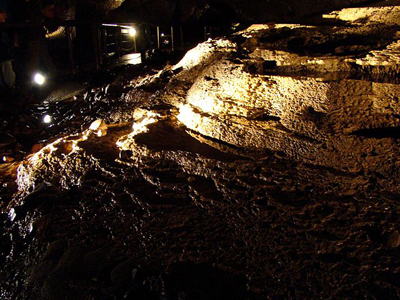
Fermanagh’s underground world
Three hundered million years ago (the Carboniferous System), what was to become Ireland was to be found around the equator as part of a continent called Laurentia. The land was desert where wind-blown sand became sandstones, some containing pebbles, which later became conglomerates. Lapping the coast was a warm tropical sea with corals, primitive fish and some very large brachiopod shells as well as microscopic shelled animals. The shells and skeletons of these animals are found fossilised in the limestones of Fermanagh. Coastal swamps and giant fern forests later became coal seams mined in, for example, Scotland.
While there are many roadside outcrops where fossils can be seen, rain and rivers erode and dissolve limestone underground. The resultant network of caves, passages, holes, and chambers attract cavers and tourists worldwide. Marble Arch Cave system is open to the public as a show cave with impressive stalactites and stalagmites and an underground lake. Other caves are only accessible with specialist equipment and experience, though guided access is available.
On the surface, streams emerge and abruptly disappear underground into swallow holes. Their valleys, formed when the ground was frozen during the last Ice Age (30,000 to 10,000 years ago), are now dry. The typically dry poor soils of limestone areas are not a problem in Fermanagh where the fertile deposits of the last Ice Age form drumlins (small hills shaped like upturned boats) with good agricultural soils.
Limestone exposed to rainfall forms characteristic karst features. These derive from the effects of rain, which is slightly acidic, dissolving the calcium carbonate rock. The water tends to drain into natural fissures and pools which deepen and widen as the rock is dissolved. The fissures (grykes) follow the grain of the rock and can be metres deep, though narrow. The pavement between the grykes (clints) may be pitted with small solution pools. Further south, the Burren is a magnificent limestone pavement while Fermanagh’s cave complexes attract speleologists and tourists.
Blanket bog
Peat forms in wet, cool, poorly drained conditions where vegetative decomposition is very slow and incomplete. North west Ireland has supported extensive bogs for up to 6,000 years. Vegetation, such as heathers, sedges, cotton grass, sphagnum moss and willows on the surface of a peat bog grow, rot very slowly and produce further layers of peat – they can be up to 5m deep. A blanket bog is one where the layer of peat is water-logged and usually occurs above 200ft (60m). The bog often has a domed profile and can occur on significant slopes. They support a wide invertebrate fauna and are considered a significant carbon sink.
Peat is at risk from a number of sources. Machine cutting of peat for horticulture and for power station fuel, drainage, afforestation and intensive grazing have considerable impacts on the extent and integrity of blanket bogs. Nutrient enrichment from atmospheric nitrogen can change the plant assemblages. Erosion by walkers and all-terrain vehicles, installation of infrastructure for wind turbines all impact on peat environments. Climate change, causing rainfall extremes which can cause bog bursts where the increased rainfall produces landslides, or lower rainfall especially in summer when dry friable peat is subject to erosion due to wind and footfall is a risk now and increasingly in the future. Here is an example of bog recovery in Fermanagh.
West Fermanagh Scarplands Area of Special Scientific Interest includes some of the best limestone pavement in Northern Ireland as well as intact blanket bog on the upper slopes and extensive semi-natural woodland lower down.
Lough Erne
Lough Erne, divided into Upper and Lower, is an extensive, relatively shallow, widened river (The Erne) whose water level is controlled by the hydro-electricity station at the western end at Cliff near Ballyshannon in the Republic of Ireland and by other control structures. The restricted capacity of the outflow produces difficulties in maintaining winter Lough levels and there was criticism of the efforts when severe flooding affected Enniskillen and other areas on the shores of the Lough in 2009.
The Lough is studded with islands, some privately owned, and is a haven for boating, fishing and wildlife. The Upper Lough is particularly challenging to navigate with its maze of islands, inlets and peninsulas. The Lough Erne Resort, where the G8 conference is to be held, is sited on one such peninsula in Lower Lough Erne. Many islands such as Devenish and Boa have Christian and pre-Christian links and artefacts including a range of stone figurines.
The plethora of islands meant that travel between them produced the Lough Erne Cot. This shallow larch planked blunt-ended vessel was either rowed or towed alongside. They were used for a wide variety of purposes from cattle transport to smuggling, school runs to distilling poitin (easy to evade the police in their deeper, slower boat). There were funeral cots and ferry cots and a fierce competition among racing cots. Traditional ones were tarred with pitch and caulked with oakum though there were later steel ones.
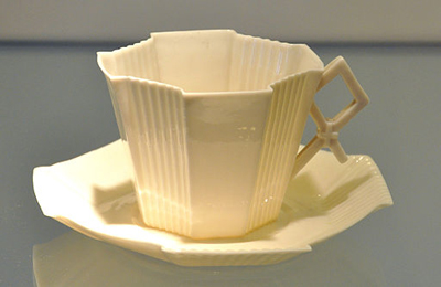 A Fermanagh cup
Fermanagh’s economy
The geographical position of Fermanagh at the western edge of Northern Ireland provides challenges for industry and commerce. No rail links and gaps in the motorway links to the rest of Ireland make land transport difficult and expensive. Within the county, the poor road infrastructure is a significant issue for moving goods, especially in larger trucks.
Employment is focused on a few large employers and unemployment is rising. There is a history of many business start-ups but they often fail as grants and support decrease. Distances to the Belfast hub mean fewer jobs are available in government departments – a major employer in the rest of NI. Despite the Northern Ireland/Republic of Ireland (ROI) border, much of Fermanagh’s focus is southwards and westwards into ROI. The focus of cultural, economic, shopping and administrative life within Fermanagh is the county town of Enniskillen. No other centre of population comes close to its size and prominence.
Much of the county’s industry is based in its natural resources. The internationally renowned Belleek pottery is founded on clay formed from the kaolin, feldspar and flint on the Belleek estate. The Irish Potato Famine provided labour eager to work and waterpower was harnessed. The clay’s ability to be moulded into intricate, light, translucent but strong shapes quickly proved popular. The Pottery is an important stop for tourists.
Fermanagh is a predominantly agricultural county with fertile, well-drained drumlin soils and sweeping upland grazing. Beef and dairy farming predominate with sheep farming increasing. Farm incomes are under threat by falling prices and farmers are encouraged to diversify. This diversification ranges from wind turbines to pony trekking, holiday accommodation to craft working. Many of these ventures are supported by grants.
Large expanses of Fermanagh are forested, mainly planted state forests and the county is home to the largest saw mill in the British Isles – Balcas at Ballinamallard. This state of the art facility produces construction timber and wood pellets for heating with an annual turnover of £65 million.
Elite Electronics produces bespoke solutions for printed circuit board construction, testing, and manufacturing systems assembly between its Enniskillen and South Carolina plants. The 200 jobs it supports in Northern Ireland are representative of the Province’s ability to compete in such a complex global environment where competitiveness is key.
Structural steelwork is the basis of Fisher Engineering, a major steel producer in Ireland. This is part of the international group Severfield-Rowen. Their portfolio includes the Emirates Stadium in London (Arsenal FC) and several London Olympic arenas and stadia.
Plans for fracking for methane in Fermanagh have caused controversy and are, as of 2013, still under consideration. One of the issues regarding the industry is that little income is likely to remain in the county.
Tourism underpins much of Fermanagh’s economy. The lakeland attracts large numbers of motorboats and sailing boats to its intricate web of waterways and islands. The Erne-Shannon waterway provides beautiful and interesting cruising. Angling is very popular with several large competitions held each year. Cuilcagh Mountain is the highest of many interesting walks with extensive views and fascinating wildlife. Outdoor pursuits such as walking, climbing canoeing and caving are well-catered for by both private businesses and education centres.
The folk tales and music of the west of Ireland attract festivals and many pubs have live music nights. Enniskillen’s Ardhowen Theatre complex provides a cultural and meeting centre, which is well used.
The range of large country houses and traditional cottages make the settled landscape widely variable. Like much of the rest of Ireland, the settlement pattern is dispersed – a few larger towns and villages with most rural dwellings scattered through the landscape rather than clumped together. This means that, apart from the wilder areas, one’s view almost always includes some buildings. The Plantation of Ulster in the early 1600s inserted many imposing houses and associated estates for English and Scottish landowners into a predominantly poor rural subsistence economy with a tribal hierarchy. Many of the origins of Ireland’s troubles can be traced to this invasion. Some of the big houses are now hotels while others are publicly accessible National Trust properties.
Find out more about the geology of Northern Ireland.
Rate and Review
Rate this article
Review this article
Log into OpenLearn to leave reviews and join in the conversation.
Article reviews