
Changing places and re-telling stories: Battle of Thermopylae
In this introductory activity, we suggest you take a look at the Hestia project map to try to understand more about how we can interpret the importance of the geography and topography at Thermopylae, site of a significant battle during the Greek and Persian Wars. This is particularly interesting since we don’t actually have any maps of the Classical period. We also consider how we tell and re-tell stories, looking at the Warner Bros. movie ‘300’ and its sequel ‘300: Rise of Empire’ in comparison with Herodotus’ narratives.
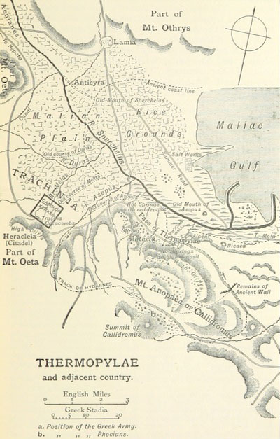 Map of the area, from a 19th century translation of Herodotus' 'The Histories'
Whilst we have considerable written and other archaeological evidence from the Classical period, there are no maps. The map illustrating this article is from ‘Herodotus: the text of Canon Rawlinson’s translation’, published in 1897 by John Murray and held at the British Library, London.
We have to deduce the Greeks’ understanding of ‘place’ from their texts, and know that in many cases the geography has changed considerably.
Some of the change has natural causes (eg earthquakes, volcanic eruptions and coastal erosion), but human impact on the environment, particularly deforestation and intensive agriculture, often seems to have led to changes in the landscape. A consequence of this change is that maps of the modern world do not necessarily accurately show the landforms and coasts of the ancient world and the change can be significant.
Scholars are now using digital tools to create more accurate cartographic maps of the ancient world: see, for example, the GIS model Antiquity a la carte and the web mapping 'tiles' created by Johan Åhlfeldt for the Pelagios project.
No longer do we, as historians of the ancient world, need to rely on Google, though you may want to explore Herodotus in Google Earth!
If you do, visit the Hestia webserver, and your application of Google Earth will open with data from the Histories, which will enable you to search for any place that Herodotus mentions and find out what he has to say about it.
To take your exploration of mapping further, look up some sources to explain what's happened to the coastline at Thermypolae in the last 2,500 years. What could the coastline have looked like when the battle took place? Compare the map from The British Library (above) with the photograph of the site today (below) and other resources you can find elsewhere.
The Battle of Thermopylae: Herodotus vs. the movie ‘300’
This famous battle between a few Spartans and the Persian army has been told and re-told by many people through the ages, with differing accounts of the terrain, tactics and size of the opposing armies. These have appeared in a range of media from plain text to historical fantasy. This variety of accounts over the ages begs an interesting question: how do we tell and re-tell stories? How important is accuracy, or are we more interested in impact? How many times have you re-told a story with your own ‘spin’ to suit the time, place or audience?
There is an interesting commentary on various versions of the battle on Livius.org. In 1997, Frank Miller used the story of the battle as the basis of his comic book, ‘300’. Tom Holland’s book, ’Persian fire’ (2006) whilst very different, takes Herodotus’ story about self-sacrifice as the founding myth of western civilisation. 19th century philosophers and historians Hegel and Mill along with 18th century art historian, JJ Winckelmann, make similar claims.
In March 2014 ‘300: Rise of an Empire’ hit cinema screens, and is now available on DVD. It describes the naval Battle of Salamis, which took place just after Thermypolae. The movie is the sequel to ‘300’, released in 2007, based on Miller’s comic book. These two films provide us with an ideal opportunity to compare the writing of Herodotus who covers both battles in ‘The Histories’ with two modern historical fantasy movies.
These modern adaptations present fictional accounts with dramatic cinematography and compelling narrative of the battles. Although they were both box office successes, the two movies were criticised by some for favouring visual impact over plot, character or narrative.
Watch the official trailer from the movie ‘300’
Follow the links below to see what Herodotus says, and look at other accounts of the battles on the Internet to develop an understanding of the basic story. Thinking about the differences, and similarities, in these treatments of the Battle of Thermopylae, what effect do you think it has on us in trying to be ‘enquiring historians’?
Exploring ‘place’ in the Classical world
 Site of the Battle of Thermopylae today
Knowing where places were, which places were near each other, and which were distant, will enrich your enquiry into the ancient world. The Hestia project provides links to help you make these connections through texts and associated markers on a map. To illustrate this, explore Herodotus’ account of the battle at Thermopylae, described in the Pelagios project as a narrow stretch of land between the mountain and the sea.
The coastline around Thermopylae has changed substantially as the result of both changes in sea-level and river-delta sedimentation. Today the mountain is at least five kilometres from the sea, as illustrated in the photo, and up to 20 metres of sediment have been laid down. This obscures the ancient topography, making it impossible to relate the description of the battle to the modern landforms.
Herodotus makes 31 references to Thermopylae in ‘The Histories’, mostly in Chapter 7. The first reference is linked here and by exploring the ‘Place Detail’ and ‘Reading View’ you can begin to see how Herodotus presents his ‘historia’ and start your own enquiry into why and how the battle took place in this particular location. Zoom in and out of the map view to see the modern-day distance from sea, read the chapters where Herodotus helps us to build up a picture of what the place was like, who was there and what they thought.
Refer to the Introductory Hestia Project map and partners’ resources for guidance in exploring the Hestia map and ideas for other online resources. Look up sources to explain what's happened to the coastline in the last 2500 years, and what the coastline could have looked like when the battle took place.
Introducing 'The Histories' by Herodotus
-
Herodotus 'The Histories'
Take part now to access more details of Herodotus 'The Histories'Find out more about our Classical past by exploring the digital text of Herodotus’ ‘The Histories’ with online mapping and an interactive map-and-narrative timeline 'mashup'.

Level: 1 Introductory
-
Understanding Classical terms
Take part now to access more details of Understanding Classical termsAnyone reading and writing about the Classical world needs to make various choices concerning consistency in defining dates, spelling and use of names. Here’s some guidance from the OU 219 Course Team.

Level: 1 Introductory
-
Classical studies: it's more than the words
Take part now to access more details of Classical studies: it's more than the wordsWhen thinking about ancient literature and historiography, we need to consider more than just the words written, but the aims of the author, role of the translator, political and cultural issues of the time of writing as well as the period in history.

Level: 1 Introductory
-
'As rich as Croesus'
Take part now to access more details of 'As rich as Croesus'Croesus' legendary wealth leads to the expression 'rich as Croesus’ and according to Herodotus, Croesus was the first monarch to mint gold and silver coins. Explore the evidence for this from the Hestia texts and other sources.

Level: 1 Introductory
Taking it further: 'The Histories' by Herodotus
-
‘Lydios logos’: the story of Croesus
Take part now to access more details of ‘Lydios logos’: the story of CroesusHerodotus tells the story of Croesus in the first tale, or ‘logos’, of his great work ‘The Histories’. Explore the contradictions in his narrative with other contemporary and archaeological evidence. Think about the extent to which Herodotus deserves his title ‘father of history’.

Level: 2 Intermediate
-
Consulting the oracle at Delphi
Take part now to access more details of Consulting the oracle at DelphiExplore the ‘riddles’ of the oracle through the words of Herodotus, and consider the power of the Pythian priestess. The utterances of the oracle at Delphi had significant influence over Croesus, King of Lydia and the Athenian politician, Themistocles as they were both consulting the oracle under different circumstances.

Level: 2 Intermediate
-
Crowdsourced annotation: what do you think?
Take part now to access more details of Crowdsourced annotation: what do you think?Take a look at 'crowdsourced' resources to help understand ‘The Histories’ alongside the Hestia project. We direct you to other resources so that you may extend your enquiry by comparing accounts, cross-referencing evidence, or verifying sources.

Level: 2 Intermediate
-
Solon upsets the wealthy Croesus
Take part now to access more details of Solon upsets the wealthy CroesusConsider the answer to Croesus’ question of him about ‘happiness’ before exploring possible routes for Solon’s journey, comparing them with travelling in the Mediterranean today. According to Herodotus, Solon, the Athenian lawmaker, spent ten years ‘sailing forth to see the world’, before meeting with Croesus in Sardis.

Level: 2 Intermediate
Rate and Review
Rate this activity
Review this activity
Log into OpenLearn to leave reviews and join in the conversation.
Activity reviews