3.2 Sites for reservoirs
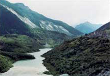
The simplest way to create a reservoir is to build a dam across a river where it flows through a narrow, deep valley. This shape of valley would enable a considerable volume of water to be stored without flooding a large area of land or building a long dam. However, it is not always possible to find such a suitable site: a narrow, deep valley may not exist, or it may be too far from where the water is needed. A wide valley needing a long dam may have to be used, or even a flat lowland area that would need a low earth embankment surrounding most, if not all, of a shallow reservoir occupying a large area of land.
In practice, the following factors have to be considered when choosing a site for a water-supply reservoir:
1. an adequate supply of preferably high-quality water;
2. a minimum of detrimental effects on the environment;
3. sufficient elevation to provide a natural flow of water to the distribution system.
Once these general points are satisfied, the specific location of the reservoir requires:
4. a reasonably watertight reservoir base and sides;
5. no geological hazards such as instability of the sides of the valley or the likelihood of earthquakes;
6. a suitable site for the dam, preferably in a narrow valley.
The most important of these requirements are an adequate supply of water (1), preferably though not necessarily of high quality, and minimal environmental implications (2). All the other requirements can often be engineered, although it may be expensive to do so: water can be treated to improve its quality (1), or pumped to a higher level (3), and geological problems such as leakage (4) and instability (5) can be minimized.
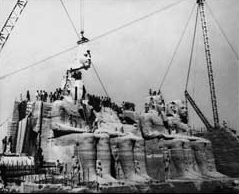
The possibility of detrimental ecological or environmental effects can provoke much opposition to plans for new reservoirs, but if the need for a reservoir is great enough and there are no alternative areas, the reservoir is usually built. For example, the proposal to build the Aswan High Dam in the 1960s provoked opposition not only in Egypt but also world-wide, partly on the ground that it would drown the ancient temples of Abu Simbel. The dam was nevertheless constructed, and some of the temples were moved (Figure 14).
The reservoir requirements that the area should be watertight, have minimal geological hazards, and have a suitable site for a dam, all involve considering the area's geology. Watertightness is affected by the permeability of the underlying rocks, as well as by the geological structure of the area, the nature of any superficial deposits, and the position of the water table.
If the underlying rocks are permeable, water may be lost from the reservoir by infiltration. Rocks with low permeability, suitable for reservoir areas, include clay-rich rocks, and most igneous and metamorphic rocks, provided they are not too highly fractured. However, reservoirs are sometimes built in areas with less suitable, more permeable rocks, such as sandstone or limestone, if no more suitable rocks are available. Such areas can be made more watertight by lining the floor with clay or injecting concrete into permeable zones, although both methods are very expensive and only suitable for small areas.
Most valley floors are covered with superficial deposits such as gravel, clay or peat. These usually have to be removed from the dam site so that the dam can be given a strong foundation in the underlying rock. Peat should be removed from the whole reservoir area as it is acidic and would affect the colour and quality of the water; but clays may be useful, as they are impermeable and can seal any underlying permeable rocks.
Problems caused by geological structures are not so easy to deal with. It is not usually possible to seal faults completely in the rocks under the area and some water may escape through them. If the rocks dip or are folded, water may be lost from the reservoir through the valley sides (Figure 15) or floor, or beneath the dam.
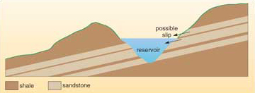
Reservoirs may contribute to the danger of landslides where a reservoir is sited on bedrock strata that dip towards the reservoir. The rocks on the right of the reservoir in Figure 15 are inclined towards it and consist of alternating sandstone and shale bands. The sandstones are permeable, and water in them percolates down to the shale bands. The shale bands are impermeable, so the water builds up above the shale until eventually it may act as a lubricant, allowing the sandstone above to slide downhill into the reservoir. This would displace a large volume of water and could cause flooding, the risk of damage and loss of life (Box 3).
Box 3 The Vaiont reservoir landslip
The Vaiont reservoir in Italy is in an area of limestones with marl bands (marl is a calcareous mudstone). The dam was completed in 1961 and was 262 m high. This was one of the highest dams in existence, and the considerable depth of water created, when the reservoir filled, raised the water table in the surrounding rocks and produced a large increase in pore pressure. This lubricated the beds of rock and, in 1963, after heavy rains, caused a large landslide which dumped enormous amounts of rock (around 2.7 × 10⁸ m3) into the reservoir from the flanking hillside (Figure 16). A huge volume of water was displaced, which surged over the dam and also back up the valley, causing around 2500 deaths in nearby villages. Remarkably, the dam itself remained intact.