

1 Landscape formation
This course is an introduction to the geological history of the British Isles, a remarkable part of the world upon which many of the great events in Earth history have left their mark. In this course we use the term ‘British Isles’ in its geographical sense, referring to the islands of Great Britain and Ireland and the adjacent lesser isles. The British Isles did not exist as such until comparatively recent times, and the surface environment of the continental crust that now forms this region has undergone dramatic changes during the geological history of the Earth.
You will gain the most from this course, and enhance your understanding of the geology of the British Isles, if you purchase the British Geological Survey's (BGS) 1:625 000 bedrock geology maps of the UK. These are available direct from the BGS [Tip: hold Ctrl and click a link to open it in a new tab. (Hide tip)] at:
Bedrock geology UK North (1:625 000 map)
Bedrock geology UK South (1:625 000 map)
(accessed October 2019).
Please note: these BGS maps have been updated since this course was first published (2008), and you may find some inconsistencies between the activity instructions and the maps.
You can also now find digital geological map data based on BGS's published poster maps of the UK on this page. There are various downloadable formats available.
They are referred to as Ten Mile Maps (N) or (S) throughout the course.
Figure 1, below, is an artist's impression of what part of northern England looked like during different periods of the region's geological history. You can see that over a relatively short period of time (~100 million years), the area experienced significant changes in:
climate (varying from subtropical to arid and semi-arid);
sea-level (with two transgressions onto the land by shallow seas); and
landmass relief (a progressive decrease in the height of the highlands).
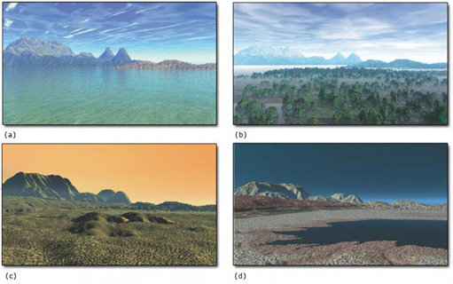
Students who attend the Open University residential school week in northern Britain associated with this course will begin to evaluate the range of environments that existed there in the geological past. In the Lake District, a deep ocean has left a thick sequence of mudstones, shales and siltstones overlying and juxtaposed to a series of volcanic rocks. In contrast, the somewhat younger rocks outcropping in the Pennines (running down the centre of northern England) were laid down in a warm shallow subtropical sea conducive to the formation of limestones containing corals and other marine organisms (Figure 1a). At several times across the region, marine conditions were interrupted by sands and silts deposited in river deltas, with organic material, which eventually formed coal, deposited in coastal swamps (Figure 1b). Later still in the Vale of Eden (south of Carlisle), alluvial fans and sand dunes indicate a desert environment (Figure 1c). This was in turn superseded by a shallow sea, now represented by limestones and evaporite deposits (Figure 1d), which are found throughout the counties of Cleveland and Durham.
In addition to this sedimentary succession, a number of igneous extrusive and intrusive episodes have left their mark. Periods of uplift, deformation and erosion have also influenced the geological history of northern England and indeed the British Isles as a whole.
Geologists find out about these and similar changes by examining the different types of rock formed throughout the geological record, and comparing them with their modern-day equivalents. A number of climatic, sea-level and topographical changes can be recognised throughout the 3.8 billion years of the geological history of the British Isles. The majority of these relate to the ever-changing position of the Earth's tectonic plates.
Throughout this course you will find that geological Periods may be prefixed by the terms, ‘Early’, ‘Mid-’ and ‘Late’, or ‘Lower’, ‘Middle’ and ‘Upper’. The first three are used in the context of time (e.g. a specific age period), whereas the last three refer to successions of rocks. So, for example, Lower Jurassic rocks were formed during the Early Jurassic.