

2.2.5 Palaeomagnetic evidence and 'polar wander'
The Earth has the strongest magnetic field of all the terrestrial planets, with similar properties to a magnetic dipole or bar magnet. As newly erupted volcanic rocks cool, or sediments slowly settle in lakes or deep ocean basins, the magnetic minerals within them become aligned according to the Earth's ambient magnetic field. This magnetic orientation becomes preserved in the rock. The ancient inclination and declination of these rocks can then be measured using sensitive analytical equipment.
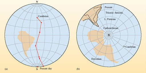
As a continent moves over the Earth's surface, successively younger rocks forming on and within that continent will record different palaeomagnetic positions, which will vary according to the location of the continent when the rock was formed. As a result, the position of the poles preserved in rocks of different ages will apparently deviate from the current magnetic pole position (Figure 4a). By joining up the apparent positions of these earlier poles, an apparent polar wander (APW) path is generated. It is now known that the Earth's magnetic poles do not really deviate in this manner, and the changes depicted in APW paths are simply a result of the continent moving over time (Figure 4b).
Nevertheless, APW paths remain a commonly used tool because they provide a useful method of comparing palaeomagnetic data from different locations. They are especially useful in charting the rifting and suturing of continents.
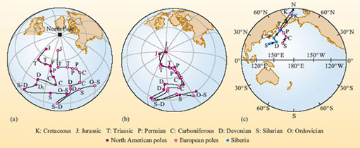
Figure 5a shows North America and Europe have individual apparent polar wander paths. However, they are broadly alike in that they have similar changes in direction at the same time. Figure 5b shows the APW paths if the Atlantic Ocean is closed by matching the continental shelves.
Question 2
What does this tell you about the North American and European continental masses during the periods spanned by these palaeomagnetic records?
Answer
The two continents were moving together as one mass from the Ordovician right through to the opening of the Atlantic Ocean during the Jurassic Period.
Conversely, if the APW paths of two regions were different to begin with, but became similar later on, one explanation would be that the two regions were originally on independent land masses that then collided and subsequently began to move together as a single continental unit.
Activity 2
What do the APW paths in Figure 5c tell you about the way in which Europe and Siberia have drifted from the Silurian Period to the present day?
Answer
The APW parts of Europe and Siberia are the same as far back as the Triassic, but before this time the Siberian pole was to the west of the European pole. This indicates that the two regions were part of different land masses until the Triassic; at this time they must have collided, and afterwards they continued to move as a single unit.
Despite Wegener's amassed evidence and the increasing body of geological, palaeontological and palaeomagnetic information, there remained strong opposition to his theory of continental drift, leaving just a few forward-thinking individuals to continue seeking evidence to support this theory (Box 1).
The scientific opposition reasoned that if continents move apart, then surely they must either leave a gap at the site they once occupied or, alternatively, must push through the surrounding sea floor during their movement. The geophysicists of the day quickly presented calculations demonstrating that the continents could not behave in this way and, more importantly, no one could conceive of a physical mechanism for driving the continents in the manner Wegener had proposed. Consequently, the theory of continental drift did not gain scientific popularity at the time and became increasingly neglected for several decades. To gain a wider scientific acceptance, Wegener's ideas had to await a greater understanding in the internal structure of the Earth and the processes controlling the loss of its internal heat.