
3.3 Constructive plate boundaries
Constructive plate boundaries or margins are regions where new oceanic crust is being generated. However, in order for the magma to ascend to the surface and build new lithosphere, the earlier formed crust must be pulled apart and fractured to create a new magma pathway. Hence constructive plate boundaries are regions of extensional stresses and extensional tectonics. The process of fracturing, injection and eruption is repeated frequently, so that tensional stresses do not have time to accumulate significantly and, as a result, constructive plate boundaries are characterised by frequent, low-magnitude seismicity (typically less than magnitude 5), occurring at shallow crustal depths (
Question 6
Why do you think earthquakes are restricted to shallow depths beneath ocean ridges?
Answer
Earthquakes can only occur in brittle rocks that fail by fracture rather than solid-state creep. As a result of high geothermal gradients beneath oceanic ridges, the brittle lithosphere is thin and so earthquakes are restricted to shallow depths.
Sonar surveying, and direct investigation by sea-floor drilling or deep sea submersibles, has revealed that volcanism along the ridge systems typically consists of a series of individual, active eruption centres. Each eruptive centre is no more than about 2-3 km long, and along the ridge axis they are often separated from each other by an inactive gap of about 1 km. Beneath the spreading ridge the feeder magma chambers that supply the volcanic centres are more continuous, often linking between and across the active segments. This means that magma generation occurs along much of the length of the ridge even though it is erupted via a chain of individual volcanic centres.
Plates move away from constructive boundaries at speeds that can be as low as −1 to so-called ultra-fast spreading ridges where half spreading rates can exceed 100 mm y−1. Examples of slow spreading ridges include parts of the mid-Atlantic Ridge and the southwest Indian Ridge. Fast and ultra-fast ridges occur in the East Pacific, along the East Pacific Rise and the Galapagos spreading centres (Figure 8).
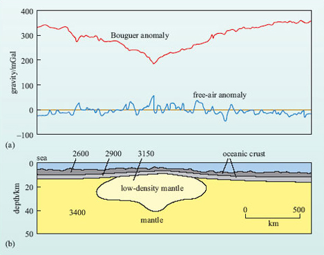
The depth structure of a constructive plate boundary can be further defined from the variation in the Earth's gravity (Box 3). Figure 15 shows gravity anomalies across the Mid-Atlantic Ridge. Despite the topographic rise associated with the ridge, the free-air gravity anomaly is relatively flat and close to zero across the whole structure. This indicates that there is no mass deficit or excess down to the level of isostatic compensation, i.e. the ridge is in isostatic equilibrium with the lithosphere of the abyssal plains. By contrast, when the free-air anomaly is corrected for the effects of the ridge topography and overall altitude, the resulting Bouguer gravity anomaly is strongly positive but with a local dip across the ridge axis. The positive anomaly occurs because of the raised topography of the ridge, but the ridge zone itself is underlain by lower-density material. A possible density model is shown in Figure 15b.
Question 7
What do you think the low-density material beneath the ridge might represent?
Answer
Hot, possibly partially molten mantle that feeds the basaltic volcanism of the ridge axis.
Box 3: Gravity and gravity anomalies
Gravity is the attractive force experienced by all objects simply as a consequence of their mass. The magnitude of the attraction is determined from Equation 3:
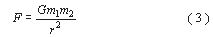
where m 1 and m 2 are the masses (measured in kg) of two objects, r is the distance (measured in m) between them and G is the universal gravitational constant (6.672 × 10⁻¹¹ N m2 kg−2).
If one object is the Earth, with mass M, and the other is a much smaller object with mass m, Equation 3 can be rewritten:
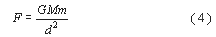
where d is the radius of the Earth, i.e. the distance to the Earth's centre of gravity.
However, the force experienced by an object at the surface of the Earth can be measured:

where m is its mass and g is the acceleration due to gravity. Hence:
Cancelling m gives
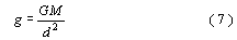
Hence g is proportional to the mass of the Earth and inversely proportional to the square of the distance from the centre of the Earth. Note that Equation 7 gives a way of measuring the mass of the Earth (M) if g can be measured and G and d are known.
-
Given that the Earth is not truly spherical and that the poles are closer to the centre than the Equator is, will g at the poles be greater than, less than or similar to g at the Equator?
-
Because the poles are closer to the centre of the Earth than the Equator, d2 in Equation 7 will be lower, therefore g will be slightly greater.
Variations in gravity are measured in milligals (mGal) and 1 mGal is equivalent to 10−5 m s−2. Since g = 9.81 m s−2, this means that 1 mGal ∼10−6g.
Measured variations in gravity across the surface of the Earth relate to the mass in the vicinity of the point of measurement. Thus a region underlain by dense rocks, such as basalt, will exhibit a slightly stronger gravitational pull than those underlain by less dense rocks, such as granite or sediments. In addition, gravity is affected by the underlying topography and the altitude at which the measurement was made. Thus measurements of the variation in the Earth's gravitational field require numerous corrections for latitude and topography, the details of which are beyond the scope of this course (but see the texts recommended in the Further Reading section). The resultant gravitational anomaly is known as a Bouguer anomaly and this reflects the variations in the Earth's gravity due to the underlying geology. Bouguer gravity is usually calculated over continental regions where the surface topography and the underlying geology are both highly variable. In marine surveys, fewer corrections are applied to the measured value of g, and gravitational anomalies are conventionally referred to as free-air anomalies. Gravity measurements, particularly over the oceans, are now routinely recorded from satellites and have resulted in accurate and detailed maps of the free-air anomaly over most of the Earth.
Hot material is generally less dense than cold material, so the low density of the mantle beneath the ridge is related to the locally high geothermal gradient, as also indicated by the presence of basaltic magma and the restriction of earthquakes to the upper levels of the lithosphere.
Finally, it should be noted that constructive plate boundaries by definition cannot occur within continental lithosphere as they must be bounded by new oceanic lithosphere. There are regions of the Earth's crust where a constructive boundary (or boundaries) can be traced into a continental region, for example at the southern end of the Red Sea and the Gulf of Aden the marine basins join and extend into the Ethiopian segment of the African Rift Valley by way of the Afar Depression. While these three features are all part of an extensional tectonic regime, the African Rift Valley cannot be considered to be a true constructive plate boundary, although, in future, if plate configurations are suitable, it may provide the site for the opening of a new ocean.