3.5 Destructive plate boundaries, continued: ocean-ocean (island-arc) subduction
The convergence of two oceanic plates represents the simplest type of destructive plate boundary and exemplifies most of the features associated with the destruction of oceanic lithosphere. Around the northern and western edges of the Pacific Ocean, many islands are arranged in gently curved archipelagos: anticlockwise these include the Aleutian Islands, the Kuril Islands, Japan, the Mariana Islands, the Solomon-New Hebrides archipelagos and the Tonga-Kermadec Islands north of New Zealand. These all occur some distance off the edge of the continental areas, but lie adjacent to a deep ocean trench. To the oceanward side of the deep trenches the ocean lithosphere is amongst the oldest on Earth. For example, the oceanic crust adjacent to the Marianas Trench, the deepest trench on Earth, is Jurassic in age and up to 180 Ma old. The trenches are sites where old oceanic lithosphere is being destroyed, or subducted, beneath younger lithosphere. For this reason, destructive boundaries are often referred to by their alternative name of subduction zones.
The typical pattern of earthquakes associated with ocean-ocean subduction is well illustrated in the interactive Figure 16 below, which shows the distribution of earthquakes associated with the Tonga Trench in the southwest Pacific. The earthquake data summarised in this diagram clearly define a zone of earthquakes deepening to the west away from the Tonga Trench, beneath the Tonga volcanic islands, and reaching a final depth in excess of 600 km. This inclined plane of earthquakes associated with the Tonga Trench (and every other deep ocean trench) in known as a Wadati-Benioff zone, after the first seismologists to recognise its existence.
Figure 16 (interactive)
Question 8
Using the information in Figure 16, estimate the angle of the Wadati-Benioff zone beneath the Tonga island arc at ∼20°S. (Assume the first occurrence of >400 km earthquakes along this line is representative of earthquakes with a minimum depth of 400 km.)
Answer
Earthquakes at about 400 km depth are located ∼400 km west of the Tonga Trench. Hence the tangent of the angle of subduction is 400/400=1, so the angle of subduction is ∼45°(tan 45°=1).
Question 9
Is the angle constant along the whole length of the Tonga Trench?
Answer
No. To the north at ∼16°S the horizontal distance between trench and the deepest earthquakes is much greater than at 20°S, so the angle of subduction is shallower.
The presence of earthquakes at great depth in Wadati-Benioff zones shows that rocks are undergoing brittle failure throughout this depth range.
Question 10
What does this observation tell you about the thermal state of subducted lithosphere?
Answer
Subducted lithosphere must remain cool to fail seismically.
Subduction involves the recycling of old, and therefore cold, oceanic lithosphere back into the mantle. A common misconception is that earthquakes represent failure between the subducted lithosphere and the overlying mantle. While this may be the case for the shallowest levels of subduction, analysis of earthquake waves from deeper seismic events indicate that earthquake foci lie within the subducted lithosphere and reflect differential movement between rigid blocks in the subducted lithosphere as it heats up and expands.
The fact that the subducted slab remains colder than ambient mantle at a comparable depth raises a problem for the generation of volcanic activity - a diagnostic feature of subduction. If subduction zones are regions where cold material is being cycled back into the mantle, why are they the site of volcanic activity? Constructive plate boundaries are underlain by regions of hot mantle that rises in response to the separation of the overlying plates and so it is easy to see how magma can be generated from the mantle. Beneath island arcs there is less evidence for hot mantle and so melting must be triggered by some alternative mechanism. Seismic profiles of subduction zones show that melt is generated immediately above the subducted plate, and most volcanic arcs are located approximately 100 km above its surface, so there is clearly a relationship between subducted oceanic lithosphere and the presence of island-arc volcanism.
The link between subduction and volcanism lies in the composition of the subducted lithosphere.
Question 11
In addition to basaltic crust and mantle rocks, what other rocks would you expect in the subducted plate?
Answer
As the plate ages it accumulates a veneer of sediments on it surface. Also hydrothermal processes close to the ridge add water to the upper layers of the basaltic crust. So the subducting plate will include sediments and altered basalt crust.
Subduction provides a mechanism for introducing water-bearing sediments into the mantle, and as the subducted lithosphere heats up the water is gradually released. Water has the effect of reducing the melting temperature of the mantle. It is this process that allows the generation of magma at depth that feeds surface volcanism. As a result, subduction-related magmas are also richer in volatiles than similar rocks from other tectonic environments, such as constructive plate boundaries.
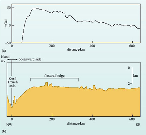
All of the above characteristics are more or less diagnostic of an oceanic destructive plate boundary. There are, however, a number of other structural features that may or may not be present, but reflect different processes associated with subduction. Figure 17b shows the mean ocean depth across the Kuril Trench in the NW Pacific Ocean. On the oceanward side of the Kuril Trench, as with all deep ocean trenches, the ocean depth is between 4 km and 6 km, whereas the trench is 2-4 km deeper still. Note that the vertical scale has been exaggerated fifty times in Figure 17b and the actual angles of the sides of the trench are quite shallow, being between 20° and 5°.
Question 12
What happens to ocean depth immediately to the ocean side of the trench?
Answer
It decreases slightly.
The decrease in ocean depth towards the trench is characteristic of all island-arc systems and can elevate the ocean floor by as much as 0.5 km. It is caused by the flexure of the lithosphere in response to its entry into the subduction zone and is known as a flexural bulge. It is analogous to flexing a ruler over the edge of a table. If you place an ordinary plastic ruler on the edge of a table so that about one-third of it protrudes over the edge and then apply pressure to the extreme tip of the ruler while holding the other end firmly on the table, the ruler will flex and the part that was lying flat on the table will rise slightly. When the pressure is released the ruler will return to its original position because it is a rigid but elastic material. (Imagine trying this experiment with plasticine.)
The flexural bulge is a common feature of ocean-trench systems and is marked by a small increase in free-air gravity, while the trench itself is marked by a large decrease in free-air gravity (Figure 17a). Such gravity variations imply that arc systems are out of isostatic equilibrium - the negative anomaly over the trench reflects a mass deficit, meaning that the crust in the trench must be being held down, while the increase over the flexural bulge implies that it is underlain by dense material beneath the plate. The interpretation is that as the plate flexes upwards it 'pulls in' the asthenospheric mantle beneath. The isostatic imbalance, with the trench held down and the bulge supported, is due largely to the rigidity of the subducting plate.
While many ocean trenches are particularly deep, others are not. However, they are still characterised by a strongly negative free-air gravity anomaly, implying that they are filled with low-density material.
Question 13
What do think this low-density material might be?
Answer
Sediments.
As a plate ages, it accumulates a veneer of deep-sea sediments made up of clays and the remains of micro-organisms in the oceans. At the subduction zone, this sedimentary cover is partly scraped off against the overriding plate to form huge wedges of deformed sediment that can eventually fill the trench system. This material is often known as an accretionary prism. Not all the sediment is removed, however, and some remains attached to the descending oceanic plate and may become attached to the base of the overlying plates or even be carried into the upper mantle.
Behind many island-arc systems, especially those in the western Pacific, small ocean basins open up between the arc and the adjacent continent. Typical examples include the ocean basins immediately to the west of the Tonga and Marianas island arcs. Various lines of evidence show that these regions of ocean crust are very young and characterised by active spreading centres. Such features are known as back-arc basins.
Question 14
Does the existence of young oceanic crust suggest an extensional or a compressional tectonic regime in back-arc basins?
Answer
An extensional tectonic regime. New ocean crust is only produced when lithospheric plates move apart.
The presence of an extensional regime in the back-arc region basin may appear counter-intuitive because where two plates are converging the dominant tectonic regime should be compressional. The mechanisms that give rise to back-arc tension may relate to convection in the asthenosphere underlying the back-arc region. Alternatively, it has been suggested that old, dense slabs may subside into the mantle at a faster rate than the plate is moving, causing the trench to migrate towards the spreading centre (euphemistically called 'slab roll-back'). This gives rise to an extensional regime not only in the back-arc basin but also across the whole arc, even to the extent of suggesting that back-arc basins may originate as arcs that have been split by extension as a consequence of slab roll-back.
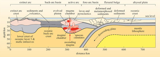
All of the major features of an oceanic destructive boundary are included in Figure 18, which is an idealised cross-section through an oceanic island-arc system.