

1.2 Land management
By the late seventeenth century, many landed estates had changed hands and were newly recorded, measured and mapped. Map-makers drew in detailed changes and cartouches carrying information about the estate owners and their antecedents. These changes in landownership and management have left historians a wide variety of evidence including maps, vistas, sale contracts and land management records and a wealth of material relating to rights over rivers, navigation, coasts and resources such as minerals, timber and game. Over the eighteenth and into the nineteenth centuries maps became increasingly detailed, so the historian can glean a great deal of evidence from them.
Activity 2
Look at this map from 1776. It shows part of a Scottish estate called Luss belonging to Sir James Colquhoun, baronet. What could you work out from this map? Jot down your ideas.
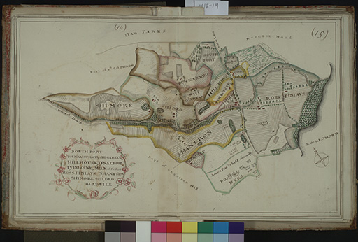
Discussion
There are many aspects that you might have noted as there is a lot of detail here. You may have jotted down any of the following points:
- The land borders part of Loch Lomond shore so we know exactly where it was.
- The field boundaries are shown.
- There is an attempt to show hills and contours.
- Roads, tracks and buildings are shown.
- The map shows areas of woodland (this was very valuable for ship building at this time).
- We can see the field and place names.
- The map straddles a county boundary.
- The language on the map is a mix of English and Scots Gaelic.
- There is an effort to differentiate land quality – some is marked as ‘very fine’.
- We even know about an event as one field is marked ‘here a Fair is held annualy’ (sic).
You can see that there is a lot of information in this map and we may begin to understand how it would help the landowner in managing the land and maximising the income from it.