
1.7.2 Interpretation of a geological exposure
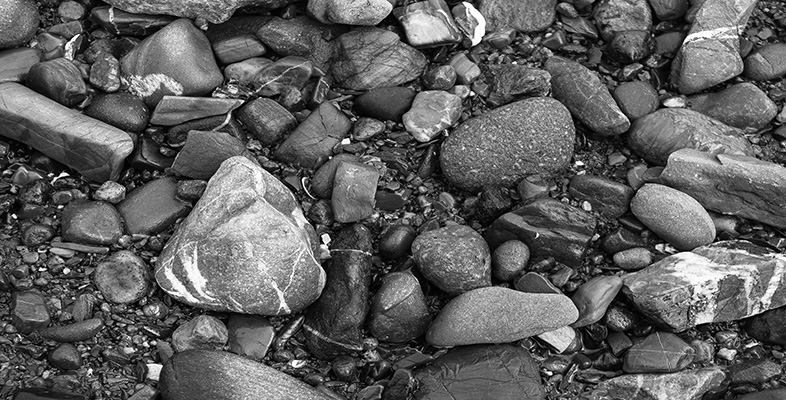
We now want to make use of the observations obtained by sketching the exposure, and it is useful to start by briefly summarising the features seen. First of all, you probably noticed the large boulder in the foreground of Figure 16 (which has been attached below for ease of access). Where did this boulder come from? It looks to have the same colour as nearby rocks so has most likely come from the same piece of coastline. However, because the boulder is not actually a part of the solid bedrock, we can't rely on it to give a true picture of the local bedrock. Boulders and any other loose rock may have been transported by natural processes or human activities, so geologists usually ignore them when investigating the rocks exposed at the surface. Indeed, much of Britain has been affected by glaciation with the result that the countryside is strewn with large boulders derived from far and wide and transported by moving ice – great for reconstructing the routes of past glaciers, but a shoal of red herrings when trying to investigate the underlying bedrock. We'll therefore ignore the boulder and concentrate on the rocks forming the solid cliffs and foreground.
The exposed rocks have sets of parallel lines running through them, and this might have been one of the first things you spotted when taking a careful look at the photograph. These lines define sedimentary layers or strata, so we are dealing with sedimentary rocks. In the rocks forming most of the vertical cliff face, the layers are horizontal, whereas in the white rocks of the foreground the layers are inclined to the right. They are like a tilted stack of books. In this case the strata slope, or dip, to the right at an angle of about 30°. The outcrop has two distinct parts – the upper set of horizontal strata and the lower part of dipping strata.
Looking first at the dipping strata, the sediments appear fairly monotonous, with no obvious change in colour or thickness of individual beds as we pass from left to right. Close up, the rock has a pitted or pock-marked appearance in places (for example the rock face immediately to the right of the large boulder). However, this is a superficial feature caused by weathering of the rock where it is exposed to the elements. The cement holding the sedimentary grains together may not be uniform, such that weathering and erosion take place unevenly, resulting in the weakest spots becoming pockmarked. Although in itself an interesting feature, it is a detail that we won't consider further.
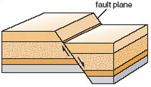
The horizontal strata are also pale in colour, though the vertical cliff that they form has some areas of black and pale green coloration. Rock faces that have been exposed for a long time often become discoloured, owing to chemical weathering or colonisation by lichens and other organisms. In this case, the black coloration is due to biological activity, and the natural colour of the rock is visible in only a few places. Green algae are growing on the lower part of the cliff where wave action provides moisture. When working at the rock exposure an Earth scientist would carefully use a geological hammer to break open the rock and expose a fresh, unweathered, surface in order to find out the true nature of the rock. As well as spotting the fairly continuous horizontal lines defining the horizontal strata (or bedding), you may also have recognised that there are a number of sharp, nearly vertical, ‘cracks’ running through the rocks. These cracks or fractures in the rock are planes of weakness known as joints. The rocks on either side of each joint have not been displaced, and this distinguishes joints from faults. A fault is a fracture across which movement has taken place, such that the rocks on either side of the fault have been systematically shifted up, down or sideways (Figure 17). Joints can form as a mechanical response to the decrease in pressure when deeply buried rocks are exhumed by the erosion of a great thickness of overlying rocks. Faults are formed when rocks break and move because of compression or stretching, with movement on either side of the fault relieving the pent-up compression or tension.
Lastly, let us turn to the junction, or contact, between the lower dipping strata and the upper horizontal strata of Figure 16.
Activity 9
What is the shape of the contact between the dipping and horizontal strata?
Answer
The contact is more or less horizontal, but with some undulations of up to about 1 m in amplitude on the left- and right-hand sides of the exposure. The cliff has become incised owing to preferential erosion along this contact.