

Image bank
This is Watching the weather's image bank. If you want to return to the unit, please click here.
record 24 of 38
| image title | Day-time infrared image from Aqua polar-orbiting satellite |
| image |  |
| caption | A mosaic of infrared images taken on the day-side of the Earth by the Atmospheric InfraRed Sounder (AIRS) from a polar-orbiting NASA satellite, Aqua, on 20 August 2007. Aqua has been placed in a 705 km altitude, 99 minute period orbit, which passes within 10° of the poles. On each orbit, the satellite crosses the Equator when the local time beneath it is 1:30pm on the day-side and 1:30am on the night side. A false colour image has been used to indicate temperatures, with the spectrum from violet to red corresponding to increasing temperature. (The key gives actual temperatures on the Kelvin scale; subtract 273.15 from these values to get the temperature in degrees Celsius.) All the images taken by the satellite during the day have been projected onto a regular latitude-longitude map. The continents are clearly visible and much warmer than the oceans. Each nearly vertical stripe which makes up the full image was taken on the day-side of the Earth on a successive orbit in the same 24- hour period. Each vertical stripe of the image was taken on the day-side of the Earth during each orbit. The date of the image was chosen to match the geostationary images from GOES East (MI025, 027, 029) for comparison; part of Hurricane Dean is seen in one stripe, but the day-side images do not quite overlap at low latitudes and so the rest of it is not seen. |
| code | MI032 |
| Section | Meteorological instruments |
| Subsection | Satellites |
| image credit | © NASA |
| thumbnail | 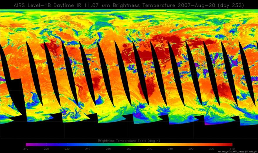 |
| File | |