

Image bank
This is Watching the weather's image bank. If you want to return to the unit, please click here.
record 25 of 38
| image title | Night-time infrared image from Aqua polar-orbiting satellite |
| image | 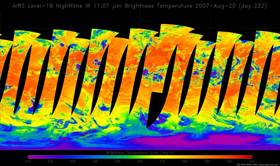 |
| caption | A mosaic of infrared images taken on the night-side of the Earth by the Atmospheric InfraRed Sounder (AIRS) from a polar orbiting NASA satellite, Aqua, on 20 August 2007. Aqua has been placed in a 705 km altitude, 99 minute period orbit, which passes within 10° of the poles. On each orbit, the satellite crosses the Equator when the local time beneath it is 1:30pm on the day-side and 1:30am on the night side. A false colour image has been used to indicate temperatures, with the spectrum from violet to red corresponding to increasing temperature. (The key gives actual temperatures on the Kelvin scale; subtract 273.15 from these values to get the temperature in degrees Celsius.) All the images have been projected onto a regular latitude-longitude map. The continents have been outlined, but you will need to enlarge the image in order to see them clearly. Each nearly vertical stripe which makes up the full image was taken on the night-side of the Earth on a successive orbit in the same 24- hour period. The date of the image was chosen to match the geostationary images from GOES East (MI025, 027, 029) for comparison; a different, and larger, part of Hurricane Dean is seen in the night-side orbits. |
| code | MI033 |
| Section | Meteorological instruments |
| Subsection | Satellites |
| image credit | © NASA |
| thumbnail |  |
| File | |