

Image bank
This is Watching the weather's image bank. If you want to return to the unit, please click here.
This is Watching the weather's image bank. If you want to return to the unit, please click here.
records 31 - 38 of 38
| image title | Stevenson screen 2 |
| caption | Air temperatures are measured at a standard height of 1.5 metres, using thermometers placed inside a ‘Stevenson screen’. This is a white painted box with an insulated floor and roof; louvered sides shade the inside from direct sunlight, but allow a gentle, free circulation of air. This particular screen is at the Radcliffe Observatory in Oxford; daily meteorological records were first started here in 1767 and a continuous record exists from January 1815, the longest series for a single site in Britain. |
| code | MI004 |
| Section | Meteorological instruments |
| Subsection | Surface-based instruments |
| image credit | © The Open University |
| thumbnail | 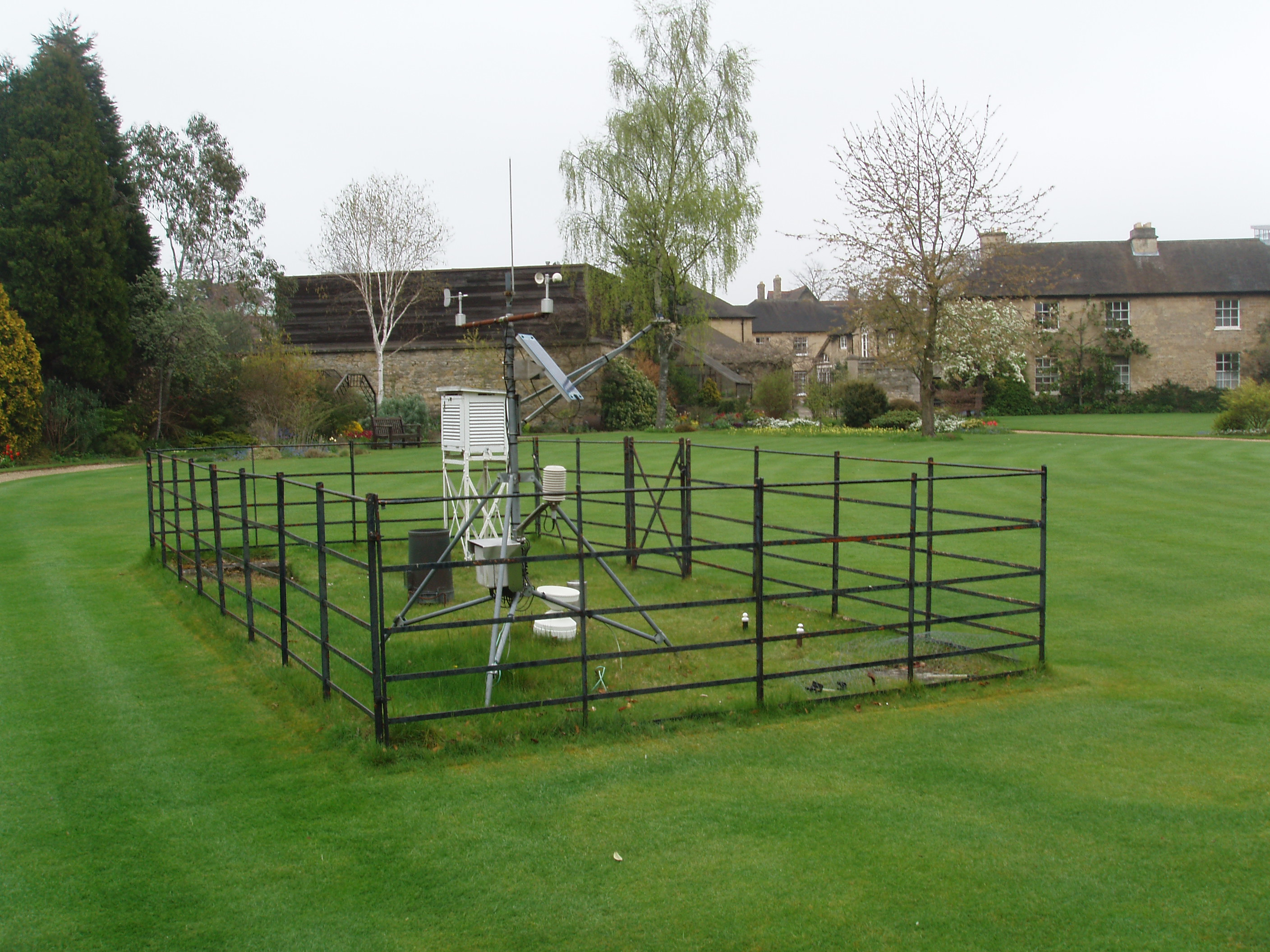 |
| File | |
| image title | Tipping bucket rain gauge |
| caption | Precipitation is measured as the depth of water (rain or melted hail or snow) that would result over any area from which the precipitation was unable to drain or soak away. The tipping bucket gauge shown here collects rain in a 100 mm funnel, so feeding water into a small see-saw structure (the tipping bucket) that tips when filled, emptying out 1.57 cubic centimetres of water. This is equivalent to a depth of 0.2 mm over the collection area. The tipping of the buckets causes the electronic register to send a pulse to the receiving unit. This gauge is suitable for remote operation, though it may not function too well in heavy snow. See also Jar rain gauge, MI014. |
| code | MI015 |
| Section | Meteorological instruments |
| Subsection | Surface-based instruments |
| image credit | © The Open University |
| thumbnail | 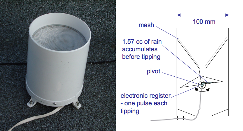 |
| File | |
| image title | Weather ship |
| caption | MV Polarfront (Norwegian Meteorological Institute, Station M) reports a full range of hourly weather observations from 66° N, 02° E, just outside the Arctic Circle in the Norwegian Sea. Automatic buoys have superceded just about all other fully crewed weather ships, but Station M has a special role as an important radiosonde launch and track station and is a major platform for gathering data for climate research. |
| code | MI018 |
| Section | Meteorological instruments |
| Subsection | Surface-based instruments |
| image credit | © Misje Rederi AS |
| thumbnail | 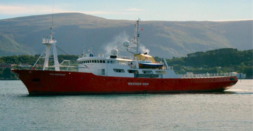 |
| File | |
| image title | Weather station 1 |
| caption | This weather station is at the Royal Botanic Gardens in Edinburgh, and has been an official weather station for the Met Office since 1956. Measurements taken with the instruments shown here include maximum and minimum air temperatures, precipitation, hours of sunshine, wind direction, visibility and cloud cover. Measurements must be made in a standard way at all observing stations, anywhere in the world, if meaningful comparisons are to be drawn between data gathered in different places. To this end, weather measuring instruments are sited away from buildings, trees and large objects, and wherever possible placed on grass, unless otherwise specified. See also Weather station 2, MI002. |
| code | MI001 |
| Section | Meteorological instruments |
| Subsection | Surface-based instruments |
| image credit | © The Royal Botanic Garden Edinburgh |
| thumbnail | 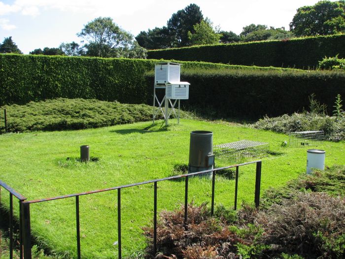 |
| File | |
| image title | Weather station 2 |
| caption | Measurements taken with the instruments shown here include maximum and minimum air temperatures, soil and ground surface temperatures, precipitation, hours of sunshine, wind direction, visibility and cloud cover. The small gantry supports automatic monitoring instruments. Measurements must be made in a standard way at all observing stations, anywhere in the world, if meaningful comparisons are to be drawn between data gathered in different places. To this end, weather measuring instruments are sited away from buildings, trees and large objects, and wherever possible placed on grass, unless otherwise specified. See also Weather station 1, MI001. |
| code | MI002 |
| Section | Meteorological instruments |
| Subsection | Surface-based instruments |
| image credit | © The Open University, by permission of The Radcliffe Observertory |
| thumbnail | 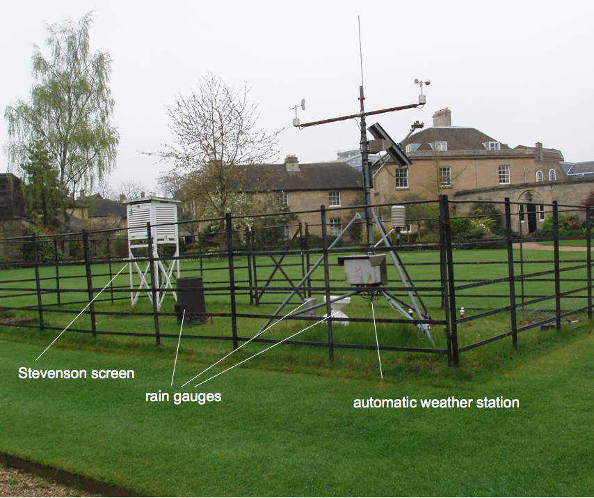 |
| File | |
| image title | Wet and dry bulb thermometers |
| caption | Inside the Radcliffe Observatory's Stevenson screen are four thermometers. The (vertical) 'dry bulb' thermometer is a mercury-in-glass instrument that measures the still air temperature. The (vertical) 'wet bulb' thermometer is a mercury-in-glass instrument that has a fabric sleeve surrounding the bulb, connected by a wick to a reservoir of distilled water. The temperature recorded by this thermometer is lowered by evaporation from the wick. Look-up tables of dry-bulb (air) temperature and the difference between the wet and dry bulb temperatures can be used to deduce the relative humidity. |
| code | MI006 |
| Section | Meteorological instruments |
| Subsection | Surface-based instruments |
| image credit | © The Open University |
| thumbnail | 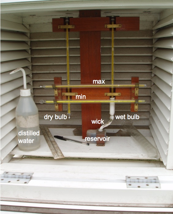 |
| File | |
| image title | Wind sock |
| caption | Wind socks are used to give pilots a visual clue as to the direction, strength and steadiness of ground-level winds, from a range of hundreds of metres. They are made from slightly tapered hollowed tubes of fabric, often coloured bright orange to ensure visibility. The wider end of the sock is held open by a stiff ring and is suspended, typically at a height of 3 m above the ground, from a vertical pole. This allows the sock to rotate freely about the pole whenever the wind fills it. The sock aligns with the wind flow provided the wind speed is in excess of 6 kilometres per hour (3 knots). The tapered section is designed to ensure that the sock begins to fill out even in relatively light air movements: it is fully extended by winds with speeds in excess of 28 kilometres per hour (15 knots). The speed of the wind can be inferred from the angle between the sock and the pole. See also Wind vane, MI011. |
| code | MI013 |
| Section | Meteorological instruments |
| Subsection | Surface-based instruments |
| image credit | Dawkeye/at Leicester Aero Club/Flickr Photo Sharing |
| thumbnail | 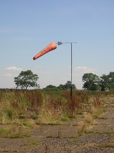 |
| File | |
| image title | Wind vane |
| caption | The direction assigned to the wind is that from which the wind is blowing. This is most easily detected using a freely rotating arm bearing a fin on one side and a pointer on the other. The fin is naturally aligned so that the wind passes equally on each side and the pointer then indicates the wind direction. |
| code | MI011 |
| Section | Meteorological instruments |
| Subsection | Surface-based instruments |
| image credit | © The Open University |
| thumbnail | 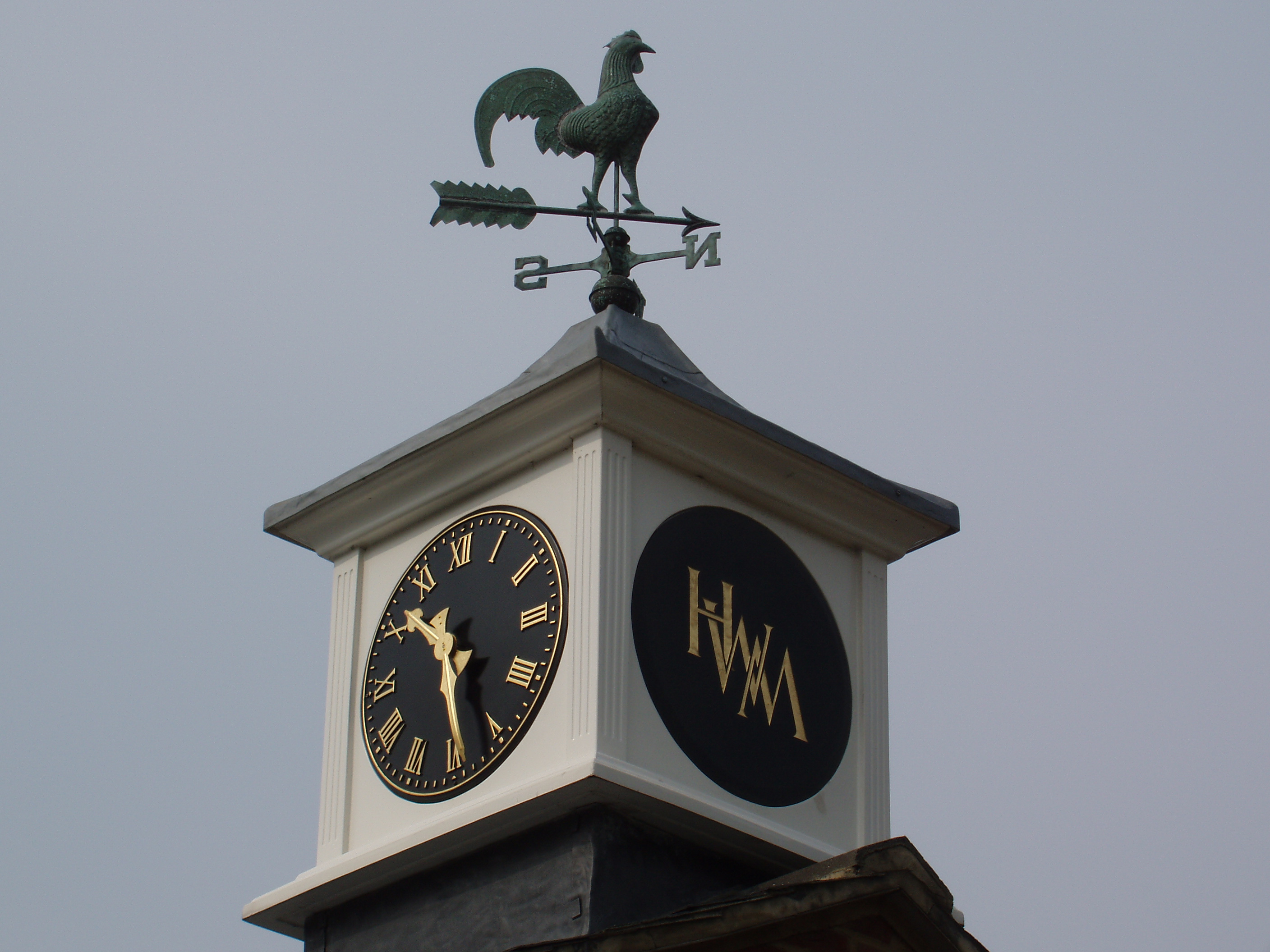 |
| File | |